Mountain hikes Maurach - Rodelhütte Jenbach - Maurach

Difficulty ratings: medium
Route length: 8.2 km
Duration: 2:00 h

Leisurely hike to the Rodelhütte above Jenbach in the Inn Valley. 190 metres of elevation gain, approx. 2 hours total walking time – perfect for a short break.

Tour information

  • Requirement: medium
  • Length: 8.2 km
  • Duration: 2:00 h
  • Elevation uphill:190 hm
  • Elevation downhill:190 hm
Highest point995 m

Starting point

Maurach, "Seespitz 1" car park

Finishing point

Maurach, car park Seespitz

Features

  • Suitable for families

Best time of year

  • January
  • February
  • March
  • April
  • May
  • June
  • July
  • August
  • September
  • October
  • November
  • December

Trail condition

asphalt road, forest path, hiking path

Equipment

Sturdy boots (ankle-high hiking boots), weather appropriate clothing. Telescopic hiking poles are recommended.
Source: Achensee Tourismus

Description

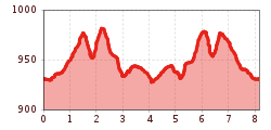
The tour starts to the left of the "Seespitz 1" car park. Follow the road for a few metres, at the restaurant Peter’s Grill walk across the road and from the car park, climb the narrow trail to the panorama trail. Turn left, follow the trail straight on, then turn right at the next junction and follow the asphalt road to the last houses of the Lärchenwiese. At the next signpost, turn left in the direction of the “Rodelhütte”. Walk across the stream bed and follow the waymarked trail until you arrive at the Rodelhütte Jenbach (920 metres). The return is via the same route.

Nearby huts and mountain restaurants

Getting here

  • Arrival by public transport

    Take the regional bus (lines 8332 or 390) to the "Seespitz 1" car park in Maurach and get off at the "Maurach Achensee Seespitz" stop.   

  • Parking

    "Seespitz 1" car park in Maurach (paid parking)

More tours in the surrounding area

  • Circular hiking trail Gleirschklamm Gorge

    Difficulty:medium
    Length:13.0 kmDuration:4:00 hElevation uphill:440 m
  • Umbal waterfalls nature force trail

    Difficulty:easy
    Length:6.0 kmDuration:2:30 hElevation uphill:257 m
  • Große Kinigat

    Difficulty:difficult
    Length:8.5 kmElevation uphill:1,250 m
  • Burgeralm

    Difficulty:medium
    Length:13.8 kmDuration:5:30 hElevation uphill:800 m
  • Fiss to the Oberen Sattelkopf

    Opening hours:closed
    Difficulty:medium
    Length:5.6 kmDuration:3:00 hElevation uphill:1,079 m
  • Oberseitsee - Seespitze 3.021 m

    Difficulty:difficult
    Length:14.4 kmDuration:8:30 hElevation uphill:1,310 m
  • Golzentipp 2.317 m

    Difficulty:easy
    Length:5.6 kmDuration:2:00 hElevation uphill:267 m
  • Toblacher Pfannhorn

    Difficulty:medium
    Length:9.8 kmDuration:4:30 hElevation uphill:1,020 m
  • Brunschkopf

    Difficulty:medium
    Length:12.8 kmDuration:4:00 hElevation uphill:395 m
  • Peace Bell Hiking Trail

    Difficulty:easy
    Length:4.6 kmDuration:1:30 hElevation uphill:92 m
  • Forscherpfad

    Opening hours:closed
    Difficulty:easy
    Length:3.4 kmDuration:1:30 hElevation uphill:219 m
  • Schober trek

    Difficulty:medium
    Length:33.0 kmDuration:30:00 hElevation uphill:3,200 m
  • Glacier trail Innergschlöss/Schlatenkees

    Difficulty:medium
    Length:9.4 kmDuration:4:50 hElevation uphill:680 m
  • Hike to Jagdhausalm 2.009m

    Difficulty:easy
    Length:16.6 kmDuration:5:00 hElevation uphill:400 m
  • Schnann - Schnanner Klamm

    Difficulty:medium
    Length:900 mElevation uphill:180 m
  • Hike to Unterleutasch

    Difficulty:easy
    Length:9.5 kmDuration:2:30 h
  • Vilser Alm Hike

    Difficulty:easy
    Length:6.6 kmDuration:2:45 hElevation uphill:348 m
Newsletter

The mountain is calling? So does our newsletter!

In our monthly newsletter we reveal the best holiday tips for Tyrol.