Mountain hikes Namlos - Jägersteig (trail)

Namlos / Lechtaler Alpen
Difficulty ratings: medium
Route length: 10.2 km
Duration: 3:30 h

Hike from Namlos through the valleys Hüttlestal, Schwarzwald and the Rappental to Stanzach.

Tour information

  • Requirement: medium
  • Length: 10.2 km
  • Duration: 3:30 h
  • Elevation uphill:224 hm
  • Elevation downhill:494 hm
Highest point1,278 m

Starting point

Namlos - Car park

Finishing point

Stanzach - Village center
  • Fitness level 3 / 6
  • Technique 3 / 6

Best time of year

  • January
  • February
  • March
  • April
  • May
  • June
  • July
  • August
  • September
  • October
  • November
  • December

Trail condition

Hiking trail (natural ground) trough many valleys and gorges

Equipment

Appropriate clothing, sturdy shoes, rain protection, sun protection, hiking poles, sufficient water. No climbing equipment required.
Source: Tiroler Zugspitz Arena

Description

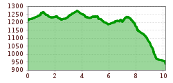
Slightly demanding, but very scenic hike. From the car park at the entrance of Namlos up to the village center and over the wide meadow path approx. 400 meters (towards Stanzach). Then the path Jägersteig begins through mostly forest areas that stretch for miles, crossing many valleys and gorges. The difficult spots are very well secured by steel cables.

IMPORTANT NOTES:
●   Stay on the marked hiking trails
●   Keep your distance from grazing animals
●   Be aware of the mountain hut opening hours
●   Alpine emergency call: 140
 

Nearby huts and mountain restaurants

Getting here

  • Arrival by public transport

    Unfortunately namlos is not connected to the public transport.
    You are dependent on arriving by car.

  • Parking

    You will find a parking lot at the entrance to Namlos.
    At your destination, in Stanzach, you have a connection to the public transport network again

More tours in the surrounding area

Newsletter

The mountain is calling? So does our newsletter!

In our monthly newsletter we reveal the best holiday tips for Tyrol.