Difficulty:
medium
Length:
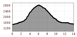
12.0 km
Duration:
5:00 h
Elevation uphill:
936 m
A round trip to the smallest of the three Tribulaune including summit, ridge walk and mountain lake.
As the name Tribulaun suggests, there are three different "Tribulaun" next to each other: Gschnitzer, Pflerscher and Obernberger Tribulaun. The Obernberger Tribulaun is with 2.780 the smallest and easiest to climb of the triumvirate. It rises at the end of the Obernbergertal and is located in a landscape conservation area. Except for a short, difficult passage with rope protection, the ascent is not particularly difficult. The tour is sometimes a bit exposed, but very varied and offers everything from a lake landscape to a stone plateau, including an impressive view from the summit.
ROUTE DESCRIPTION
From the car park at the Gasthaus Waldesruh, first take the forest path or the meadow path No. 128 towards Obernberger See. From the southern tip of the lake, you follow trail nr. 91 to the right for a short stretch through the forest until you reach a fork where the trail to Tribulaun branches off the lake. Continue for about 250 m on a forest path until the end of which path n.129 begins. At first you climb up quite steeply through a belt of mountain pines, then over open mountain slopes and on to the key point, a short passage secured by rope. Once this is done, one reaches the ridge at about 2,400 m. Once at the top there is an interesting sight: a plateau with stone slabs and rocks interspersed with green grass. The last part up to the summit with a cross is now pleasant and can be reached with no difficulty. From the summit, one has a breathtaking view: Habicht, Serles and the Nordkette in the north, Olperer, Fußstein and Schrammacher in the east and the countless peaks of the Dolomites in the south. A view down reveals the two-part turquoise-blue Obernberger See and the gentle Obernbergtal.
The descent over the Roßlauf, Pfeiferspitzen and Portjoch to the Obernberger See is very rewarding. You follow trail nr. 129 from the summit to the west and then trail nr. 32 along the ridge. A passage with a steel ladder has to be overcome, the terrain is partly right-sided! An easy hiking trail leads from the Portjoch to the lake, and from the far end of the Obernberger See you then walk along the right bank of the lake (trail nr. 93) back to the former Seegasthof and down to the car park at the starting point.
*** Translated with www.DeepL.com/Translator (free version) ***

")
.JPG")


