Difficulty:
easy
Length:
10.3 km
Duration:
4:00 h
Elevation uphill:
507 m
Small Schafkopf
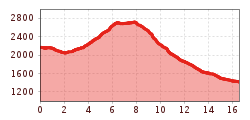
Bergkastel mountain station, follow the Mountain trail no. 30 to the Piengalm area and continue along Trail no. 23 into the Saletztal valley. Route no.21 leads to Mataun pastures, where the ascent begins via Trail no.46. After crossing the Saletzbach, the route climbs moderately north. Continue over alpine pastures to the Schafkar lakes and along a ridge to the small Schafkopf (2,742 m). Then the rope walk leads to the Gueserkopf (2,740 m). The descent is from Tscheyjoch via Trail no. 24 to the Jochelius mountain resort. After a leisurely stop, you hike back to Nauders (No. 19).


.jpg")
.jpg")

