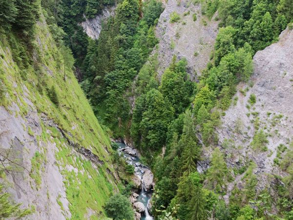
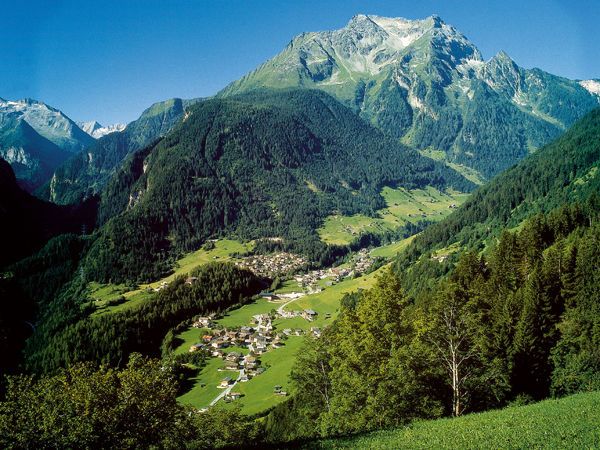
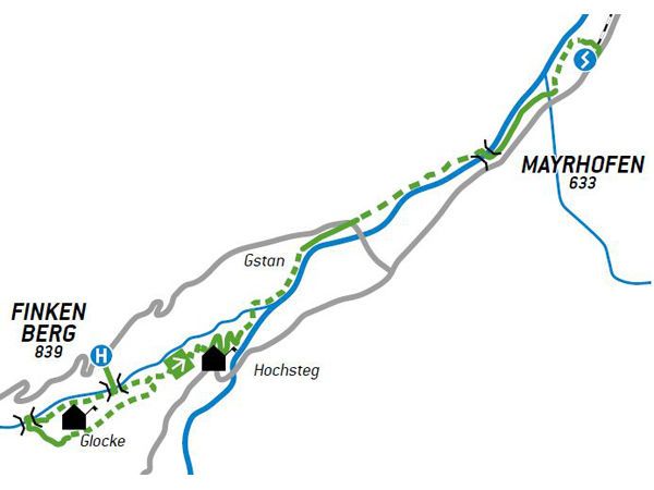
Die Glocke ist ein Naturjuwel in Finkenberg. Eindrucksvolle Wanderung mit tiefen Einblicken in die Tuxbachklamm bis Mayrhofen.
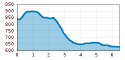
Open interactive mapOpen this POI on the interactive mapElevation profiledownloadWöffi Tour 2: Durch den Schluchtwald in die Metropole.gpx
Kaiserjochhaus © Lechtal Tourismus Lechtaler Höhenweg: 3. Etappe Kasierjochhaus-Ansbacher HütteDifficulty:difficultLength:7.8 kmDuration:4:45 hElevation uphill:844 mSee trailSee trail: Lechtaler Höhenweg: 3. Etappe Kasierjochhaus-Ansbacher Hütte
Wildschönau Auffach Schatzberg Familienwanderung.jpg © Wildschönau Tourismus Johannes Sautner Rechte Skijuwel und Wildschönau Schatzberg and Joel SpitzeDifficulty:mediumLength:7.3 kmDuration:3:00 hElevation uphill:400 mSee trailSee trail: Schatzberg and Joel Spitze
Der Murmliweg in Serfaus © © Serfaus-Fiss-Ladis Marketing GmbH Marmot TrailOpening hours:openDifficulty:easyLength:573 mDuration:0:20 hElevation uphill:12 mSee trailSee trail: Marmot Trail
Kasseler Hütte © Reinhard Weber Stage Berliner Höhenweg (Zillertal Runde): Kasseler Hütte - EdelhütteDifficulty:difficultLength:13.0 kmDuration:9:00 hElevation uphill:800 mSee trailSee trail: Stage Berliner Höhenweg (Zillertal Runde): Kasseler Hütte - Edelhütte
Nauders mountain trailDifficulty:mediumLength:18.0 kmDuration:7:00 hElevation uphill:407 mSee trailSee trail: Nauders mountain trail
The Zirbenweg trailDifficulty:easyLength:7.0 kmDuration:2:30 hElevation uphill:200 mSee trailSee trail: The Zirbenweg trail
img_9853.jpg © @ualm.at 3-hut hikeDifficulty:mediumLength:13.2 kmDuration:6:00 hElevation uphill:1,120 mSee trailSee trail: 3-hut hike
Naturparkhaus_mit Wanderer.JPG © TVB Pitztal Kaunergrat Circular Route - 7 DaysDifficulty:difficultLength:66.4 kmElevation uphill:5,496 mSee trailSee trail: Kaunergrat Circular Route - 7 Days
Abstieg in Richtung Oberstalleralm © edifilm75 Herz-Ass VillgratentalDifficulty:mediumLength:75.6 kmDuration:34:00 hElevation uphill:5,703 mSee trailSee trail: Herz-Ass Villgratental
St. Sigmund - Pforzheimer Hütte mountain hut (145)Difficulty:mediumLength:14.1 kmDuration:5:00 hElevation uphill:781 mSee trailSee trail: St. Sigmund - Pforzheimer Hütte mountain hut (145)
sommer-steinbockmarsch-foto-dominic-ebenbichler © Archiv TVB Mayrhofen Stage of the Berliner Höhenweg (Zillertal Runde): Berliner Hütte - Greizer HütteDifficulty:difficultLength:10.2 kmDuration:6:30 hElevation uphill:1,200 mSee trailSee trail: Stage of the Berliner Höhenweg (Zillertal Runde): Berliner Hütte - Greizer Hütte
Stage of the Berliner Höhenweg (Zillertal Runde): Greizer Hütte - Kasseler HütteDifficulty:difficultLength:9.8 kmDuration:6:00 hElevation uphill:650 mSee trailSee trail: Stage of the Berliner Höhenweg (Zillertal Runde): Greizer Hütte - Kasseler Hütte
Großer MutzkopfDifficulty:easyLength:10.3 kmDuration:4:00 hElevation uphill:507 mSee trailSee trail: Großer Mutzkopf
Karwendelhaus mit Bergpanorama © Region Seefeld, Miriam Mayer Karwendelmarsch 52 kmDifficulty:mediumLength:53.5 kmDuration:19:00 hElevation uphill:2,180 mSee trailSee trail: Karwendelmarsch 52 km
Wanderer vor der Nördlinger Hütte © Region Seefeld, newcreatings Hike via Nördlinger Hütte to Reither SpitzeDifficulty:difficultLength:9.9 kmDuration:7:30 hElevation uphill:1,190 mSee trailSee trail: Hike via Nördlinger Hütte to Reither Spitze
JuifenalmDifficulty:mediumLength:9.5 kmDuration:3:30 hElevation uphill:585 mSee trailSee trail: Juifenalm
muhs-pyramide-panoramaweg-herbst23-c-anna-ladstaetter.jpeg © Anna Ladstätter Muhs panorama trailDifficulty:mediumLength:15.2 kmDuration:6:00 hElevation uphill:1,090 mSee trailSee trail: Muhs panorama trail
Kaunergrathütte © TVB Pitztal/Roman Huber Kaunergrat Circular Route - 3 DaysDifficulty:difficultLength:22.8 kmDuration:13:00 hElevation uphill:2,650 mSee trailSee trail: Kaunergrat Circular Route - 3 Days
Mountain hut tour: Birgitzköpfl - Muttereralm - Götzner Alm - Birgitzer AlmDifficulty:mediumLength:11.4 kmDuration:3:30 hElevation uphill:894 mSee trailSee trail: Mountain hut tour: Birgitzköpfl - Muttereralm - Götzner Alm - Birgitzer Alm
loebbentoerl-schlatenkees-sommer-2024-c-bernhard-assmair.JPG © Bernhard Aßmair Venediger altitude trailDifficulty:difficultLength:55.5 kmDuration:27:00 hElevation uphill:3,975 mSee trailSee trail: Venediger altitude trail
Koasatrail Etappe 3 Region St. Johann in Tirol - Oberndorf - Kirchdorf - Erpfendorf © Sportalpen Koasa Trail Stage 3Difficulty:mediumLength:19.9 kmDuration:7:10 hElevation uphill:730 mSee trailSee trail: Koasa Trail Stage 3
Koasatrail Etappe 5 Region St. Johann in Tirol - Oberndorf - Kirchdorf - Erpfendorf © Sportalpen Koasa Trail Stage 5Difficulty:mediumLength:14.0 kmDuration:6:45 hElevation uphill:935 mSee trailSee trail: Koasa Trail Stage 5
Suspension bridge to Maria Locherboden pilgrimage churchDifficulty:mediumLength:8.5 kmDuration:3:00 hElevation uphill:370 mSee trailSee trail: Suspension bridge to Maria Locherboden pilgrimage church
Sonnenaufgang_Kleiner_Gilfert_©FranzKupfner.jpg © (c) Ferienregion Fügen-Kaltenbach im Zillertal, Franz Kupfner Hochfügen - Kleiner Gilfert (2388m) Walk no. 27Difficulty:mediumLength:14.4 kmDuration:6:00 hElevation uphill:925 mSee trailSee trail: Hochfügen - Kleiner Gilfert (2388m) Walk no. 27
Axamer Lizum to Halsl and then on to Saile/NockspitzeDifficulty:mediumLength:9.4 kmDuration:5:00 hElevation uphill:886 mSee trailSee trail: Axamer Lizum to Halsl and then on to Saile/Nockspitze
Give feedback for a chance to win a special holiday experience!Click here for the surveyClick here for the survey


.jpg")


.jpg")


