
Difficulty:medium
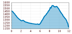
Length:11.3 kmDuration:6:00 hElevation uphill:650 m
How entertaining twelve kilometers of hiking can be: The trail through the Tyrolean Gailtal valley offers a variety of insights and views. A farm experience detour "To the bees" is certainly also included!
With a walking distance of 12 kilometers and an ascent of just over 700 meters, the third day is the longest, but scenically varied stage of the Höfe Trail. The destination is the village of Untertilliach, where you can watch beekeeper Josef Schmidhofer at work with his bees and lend him a hand. Of course, you can also taste the honey. It is then not far to the small hamlet of "Wacht".
Due to tree damage, it will not be possible to walk the farm trail until 2021. However, the farm experiences will take place as part of the weekly program of the TVB Osttirol.
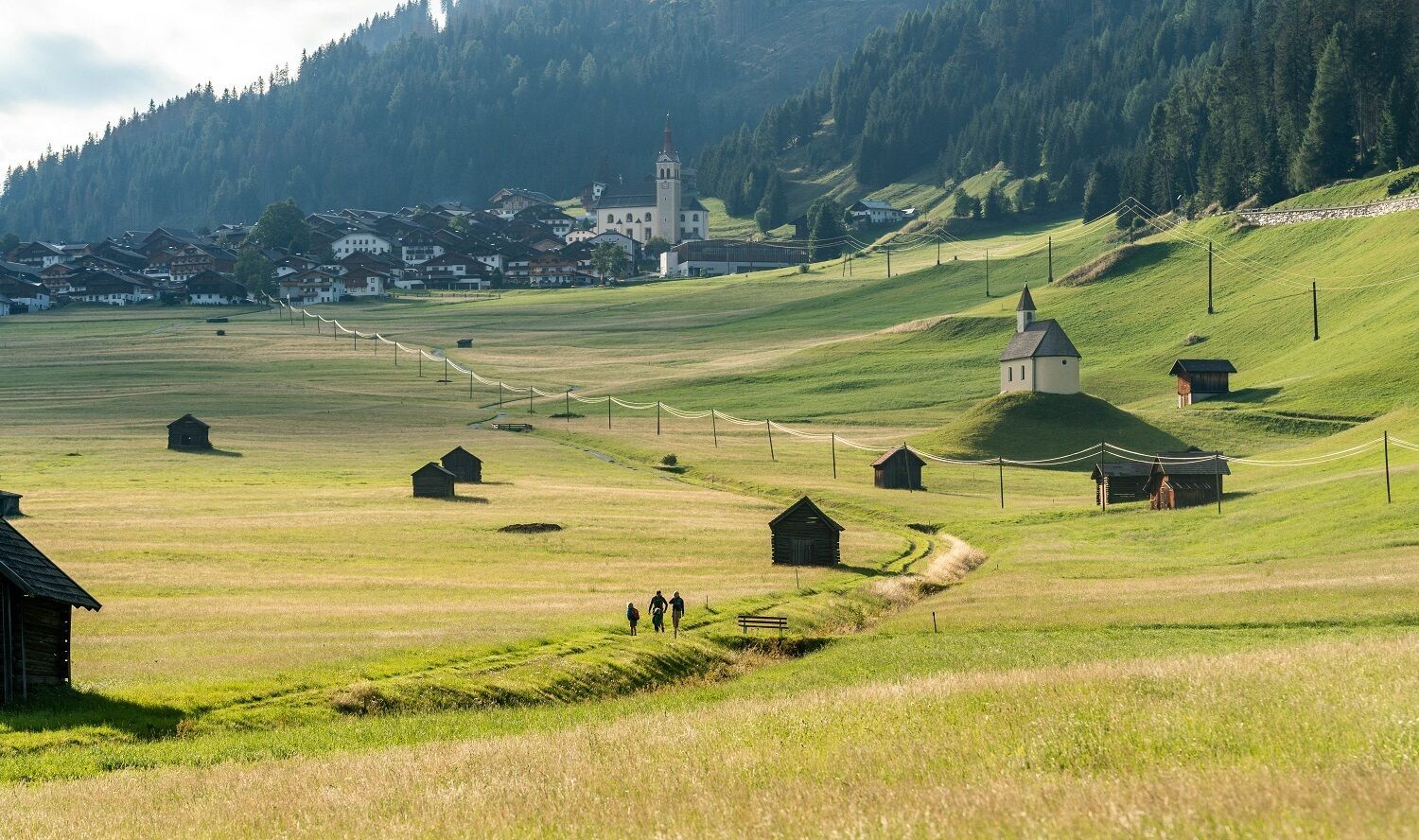
This stage starts directly in the center of Obertilliach, below the "Weiler-Kornkasten". It first goes downhill through the village, past the Unterwöger inn, to the junction with the main road below the Obererlacher bakery. We follow the main road for approx. 80 m to the left and then turn right again diagonally downhill. After approx. 150 m we pass the last houses and the view opens up over the "Obertillga Dorfer Felder", a unique cultural landscape on the alluvial cone of the Rodarmbach, with countless meadow plots and barns and the two chapels "Helenenkirchl" and "Niklaskirchl". We follow an initially asphalted goods road, keep left and soon find ourselves on a gravel field path along a stream that leads directly past the two chapels.
In the Bachhäusl district we turn right and follow the Gärberbach downhill, here we have a beautiful view back over the village fields and Obertilliach. We cross the Gärberbach stream directly at the sawmill (keep left!).
The path now runs along the banks of the Gail. At the next bridge, after approx. 1.5 km, turn right to the Soldhäuser and the herb garden of Iris Meyer (wild herb manufactory) (approx. 300 m). In the direction of Untertilliach, however, we stay on the left side of the stream until the next bridge. Here we cross the Gail and leave the stream bank, but after approx. 700 m we cross the Gail again for the last time over a wooden bridge back to the left side and walk up the asphalt road to the village of Untertilliach.
We meet the main road again at the bridge over the Nieschenbach in Untertilliach.
On the left-hand side of the bridge in front of us, we take a side road up to the Klammberg to Josef Schmidhofer's apiary (approx. 1.3 km, approx. 30 min, same route back). On the right-hand side of the bridge, in front of the municipal office, the route leads up to the Kirchberg, the last section of the stage. If you look to the other side of the stream at the municipal office, you can see the Niescher Mühle mill. We follow the side road, which winds its way up over 7 hairpin bends, and pass increasingly beautifully situated wooden farmhouses, such as the Moos Hof with its Swedish riders. Above the last house, Oberkreiner, the path makes a left turn into the forest, where we branch off to the right onto a hiking trail towards Eggen. However, the short detour to the church of St. Ingenuin and Albuin, which you can already see at the turn-off and which is one of the oldest in the entire valley, is still worthwhile. Soon after the junction, the path continues towards Eggen and crosses the Kircherbach stream over a small wooden bridge. On the opposite side, the trail then climbs slightly and runs along the lower edge of mountain meadows until it turns into a gravel road. This is the start of an extremely scenic section through meadows with individual groups of trees and barns, with the Carnic ridge always in full view. The landscape is not only attractive for us, but also ecologically significant - wild bees and other flower visitors get their money's worth here. We soon come to the bend in a better developed forest path, which we follow downhill. This soon turns into an asphalt side road. Coming from above, we reach Eggen, the "granary" of the Lesach Valley. After 4 hairpin bends we reach the Untererschbaum Hof. We follow the asphalt road further downhill and, after passing the small church, branch off to the left at the farms in Untereggen, with the Ganner granary on the right of the path. The tarmac soon ends and an ancient cart track takes us - first across meadows and then through the forest - in several bends down to "die Wacht", the stage finish.


.jpg")
.jpg")


.jpg")


