
Panoramatrail

Söll /
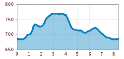
Route length: 8.4 km

Tour information

  • Length: 8.4 km
  • Elevation uphill:130 hm
  • Elevation downhill:130 hm
Highest point772 m

Starting point

Sports ground, Söll (687 m)

Finishing point

Sports ground, Söll (687 m)
  • Fitness level 2 / 6
  • Technique 2 / 6

Best time of year

  • January
  • February
  • March
  • April
  • May
  • June
  • July
  • August
  • September
  • October
  • November
  • December

Equipment

Running shoes or trail running shoes (depending on the route), comfortable, breathable clothing, poss. lightweight rucksack with water bottle and snacks
Source: TVB Wilder Kaiser

Description

Starting from the sports field, the route starts along the house stream in the direction of the village center, past the 'alte Sennerei', then slightly uphill towards Pirchmoos. At the turn-off on the left at the Pirchmooserkapelle, the route continues into the Brosenweg, which was renovated in 2023. At the intersection in front of Ferienwohnung Lederer, turn left and follow the road slightly uphill. At the intersection just before the Hitscherhof, the paved road turns into a gravel road and leads you towards the forest border where you turn right at the first junction and continue along the edge of the forest to the Hotel Alpenschlössel. Past the hotel you will find yourself at a road junction, at which you turn left in the direction of the Reiter Dörfl. At the lower end of the settlement, a narrow path leads you again on the left through the green meadow away from the asphalted municipal road. You will then reach the Sunnseit Weg, which leads to the Franzlhof leisure complex. Via the Dorfbichl it goes back down towards the village center, you turn left at the Hotel Feichter to get back on the path of the house stream and finally find the football field in front of you again.
 

Getting here

  • Arrival by public transport

    KaiserJet stop "Söll Kreisverkehr - Steig B" or Postbus stop "Söll Kreisverkehr"
    More information at: www.wilderkaiser.info/mobility
     

  • Parking

    Coming from Wörgl, Kufstein or St. Johann on the B178 main road, take the exit to Söll. At the traffic circle, take the Söll Zentrum exit and turn right again. After the MPreis supermarket, turn left into the East Wilder Kaiser car park. 
     
    Public car park East Wilder Kaiser, Söll - free of charge
     

Weather

Today

partly Cloudy
11°C/2°C
15%0l5 km/h

Tue

mainly clear
15°C/1°C
10%0l0 km/h

Wed

light rain
11°C/4°C
70%4.1l0 km/h
Go to weather forecast

More tours in the surrounding area

  • Tauernblick panorama circular hiking route

    Difficulty:medium
    Length:13.6 kmDuration:6:00 hElevation uphill:980 m
  • “Moor & more” Rocky Way

    Difficulty:easy
    Length:8.0 kmDuration:3:00 hElevation uphill:380 m
  • Panoramic circuit Brandstadl–Hartkaiser

    Difficulty:easy
    Length:6.0 kmDuration:1:50 hElevation uphill:170 m
  • Winter walking Biedringer Platte

    Opening hours:closed
    Length:12.7 kmDuration:5:30 hElevation uphill:470 m
  • Hochalm hike

    Difficulty:medium
    Length:19.6 kmDuration:7:00 hElevation uphill:1,140 m
  • MTB Tour Söll - Hochsöll

    Difficulty:medium
    Length:5.1 kmElevation uphill:480 m
  • Hintere Goinger Halt summit tour

    Difficulty:difficult
    Length:9.3 kmDuration:6:30 hElevation uphill:1,090 m
  • Kaiserkrone - stage 1

    Difficulty:medium
    Length:8.0 kmDuration:4:30 hElevation uphill:1,120 m
  • Astberg circular hiking route

    Difficulty:easy
    Length:1.5 kmDuration:0:30 hElevation uphill:80 m
  • Astberg Trail

    Length:9.7 kmElevation uphill:500 m
  • Eagle Walk Stage 02: Gaudeamushütte - Kaindlhütte

    Difficulty:medium
    Length:15.1 kmDuration:6:30 hElevation uphill:888 m
  • Kaiserkrone - stage 3

    Difficulty:medium
    Length:9.3 kmDuration:4:30 hElevation uphill:840 m
  • 3-day hut tour Wilder Kaiser

    Difficulty:difficult
    Length:24.6 kmDuration:14:00 hElevation uphill:2,060 m
Newsletter

The mountain is calling? So does our newsletter!

In our monthly newsletter we reveal the best holiday tips for Tyrol.
