Winter hike Hinterhornbach - Along the Hornbach

Hinterhornbach / Allgäuer Alpen
Difficulty ratings: easy
Route length: 3.9 km
Duration: 1:15 h

Winter hike along the Hornbach stream.

Tour information

  • Requirement: easy
  • Length: 3.9 km
  • Duration: 1:15 h
  • Elevation uphill:85 hm
Highest point1,171 m

Starting point

Gufelbridge

Finishing point

Gufelbridge

Features

  • Suitable for families

Best time of year

  • January
  • February
  • March
  • April
  • May
  • June
  • July
  • August
  • September
  • October
  • November
  • December

Trail condition

Groomed hiking trail

Equipment

Good equipment is essential for your hike. The following items should definitely be in your rucksack: - Food and drink - Functional clothing for rain, wind and cold - A change of clothes - Sun protection - First aid kit - Mobile phone with a full battery (Euro emergency number 112) - Hiking map or GPS - Hiking poles Nevertheless, the following applies: light luggage is also easier to carry, so you should not weigh down your rucksack with unnecessary ballast. In addition, your hiking equipment should of course also be adapted to your particular hiking tour.
Source: Lechtal-Reutte

Description

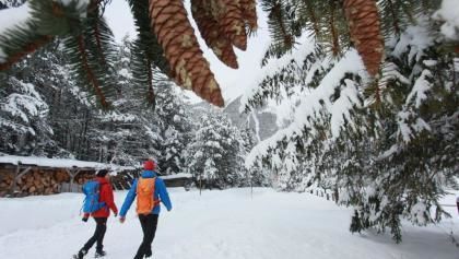
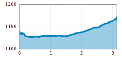
Your winter hike along the Hornbach starts at the western end of Hinterhornbach.
You follow the Hornbach until you reach the unmanaged Drähhütten huts after around 3.9 kilometres.
After a well-earned rest, turn your back on the huts and take a leisurely stroll back to Hinterhornbach. Incidentally, you can also tackle the hike on touring skis.

Getting here

  • Arrival by public transport

    Regiobus Hinterhornbach

  • Parking

    Hinterhornbach village

Newsletter

The mountain is calling? So does our newsletter!

In our monthly newsletter we reveal the best holiday tips for Tyrol.