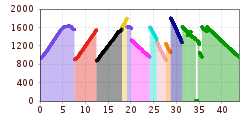
Open interactive mapOpen this POI on the interactive mapElevation profiledownloadINTERN LAURA BIKE-KARTE BIKEPARK.gpx
The Zirbenweg trailDifficulty:easyLength:7.0 kmDuration:2:30 hElevation uphill:200 mSee trailSee trail: The Zirbenweg trail
St. Sigmund - Pforzheimer Hütte mountain hut (145)Difficulty:mediumLength:14.1 kmDuration:5:00 hElevation uphill:781 mSee trailSee trail: St. Sigmund - Pforzheimer Hütte mountain hut (145)
JuifenalmDifficulty:mediumLength:9.5 kmDuration:3:30 hElevation uphill:585 mSee trailSee trail: Juifenalm
Through the Forest from Praxmar to LüsensDifficulty:mediumLength:5.0 kmDuration:0:47 hElevation uphill:54 m:Style: ClassicGo to Cross-country skiing trailGo to Cross-country skiing trail: Through the Forest from Praxmar to Lüsens
Winter hiking trail Speichersee-GfasDifficulty:easyLength:3.5 kmDuration:2:30 hElevation uphill:103 mGo to winter hikeGo to winter hike: Winter hiking trail Speichersee-Gfas
Winterwandern auf dem Wiesenweg © Region Seefeld Stage 3: From Mösern to Wettersteinhütte – Tyrol’s 1. Winter Multi-day HikeOpening hours:closedDifficulty:mediumLength:14.4 kmDuration:4:15 hElevation uphill:210 mGo to winter hikeGo to winter hike: Stage 3: From Mösern to Wettersteinhütte – Tyrol’s 1. Winter Multi-day Hike
Rangger Köpfl OberperfussDifficulty:easyLength:10.0 kmDuration:4:00 hElevation uphill:577 mSee trailSee trail: Rangger Köpfl Oberperfuss
Faltegartenköpfl Difficulty:easyLength:8.8 kmDuration:2:30 hElevation uphill:430 mGo to skitourGo to skitour: Faltegartenköpfl
Innsbruck to KühtaiDifficulty:difficultLength:110.0 kmDuration:4:30 hElevation uphill:1,600 mGo to biketourGo to biketour: Innsbruck to Kühtai
The Arzler Alm Trail (5007)Difficulty:mediumLength:3.8 kmDuration:0:15 hGo to biketourGo to biketour: The Arzler Alm Trail (5007)
The Hungerburg Trail (596)Difficulty:difficultLength:550 mDuration:0:15 hGo to biketourGo to biketour: The Hungerburg Trail (596)
Mountain hut tour: Birgitzköpfl - Muttereralm - Götzner Alm - Birgitzer AlmDifficulty:mediumLength:11.4 kmDuration:3:30 hElevation uphill:894 mSee trailSee trail: Mountain hut tour: Birgitzköpfl - Muttereralm - Götzner Alm - Birgitzer Alm
The sunny plateau circuitDifficulty:easyLength:38.0 kmDuration:8:00 hElevation uphill:740 mSee trailSee trail: The sunny plateau circuit
Lüsens Training RunDifficulty:easyLength:700 mDuration:0:10 hElevation uphill:7 m:Style: Skating, ClassicGo to Cross-country skiing trailGo to Cross-country skiing trail: Lüsens Training Run
Bergdoktor-Winter Hiking TrailDifficulty:easyLength:2.1 kmDuration:0:45 hElevation uphill:40 mGo to winter hikeGo to winter hike: Bergdoktor-Winter Hiking Trail
Suspension bridge to Maria Locherboden pilgrimage churchDifficulty:mediumLength:8.5 kmDuration:3:00 hElevation uphill:370 mSee trailSee trail: Suspension bridge to Maria Locherboden pilgrimage church
Along the Goetheweg trail to thePfeishütte mountain hutDifficulty:difficultLength:5.2 kmDuration:5:00 hElevation uphill:769 mSee trailSee trail: Along the Goetheweg trail to thePfeishütte mountain hut
Axamer Lizum to Halsl and then on to Saile/NockspitzeDifficulty:mediumLength:9.4 kmDuration:5:00 hElevation uphill:886 mSee trailSee trail: Axamer Lizum to Halsl and then on to Saile/Nockspitze
The Tiroler Run in LüsensDifficulty:easyLength:5.5 kmDuration:1:11 hElevation uphill:69 m:Style: Skating, ClassicGo to Cross-country skiing trailGo to Cross-country skiing trail: The Tiroler Run in Lüsens
The Sellrainer Höhenwanderweg trailDifficulty:difficultLength:15.0 kmDuration:7:00 hElevation uphill:900 mSee trailSee trail: The Sellrainer Höhenwanderweg trail
Solsteinhaus© Innsbruck Tourismus _ Luca Jaenichen.jpg © Solsteinhaus _ Innsbruck Tourismus Luca Jaenichen Solsteinhaus mountain hut (Alpenverein route 213)Difficulty:mediumLength:13.6 kmDuration:6:22 hElevation uphill:876 mSee trailSee trail: Solsteinhaus mountain hut (Alpenverein route 213)
The Neue Magdeburger Hütte - MTB route (543)Difficulty:difficultLength:16.3 kmDuration:3:24 hElevation uphill:1,001 mGo to biketourGo to biketour: The Neue Magdeburger Hütte - MTB route (543)
The Athletes' Run in LüsensDifficulty:mediumLength:11.0 kmDuration:3:00 hElevation uphill:205 m:Style: Skating, ClassicGo to Cross-country skiing trailGo to Cross-country skiing trail: The Athletes' Run in Lüsens
Potsdamer-Hütte.jpg © Innsbruck Tourismus The Sellrain Valley Mountain Hut TourDifficulty:difficultLength:84.3 kmDuration:7 daysElevation uphill:5,085 mSee trailSee trail: The Sellrain Valley Mountain Hut Tour
Potsdamer-Hütte.jpg © Innsbruck Tourismus The Sellrain Valley Mountain Hut Tour: stage 2Difficulty:mediumLength:15.9 kmDuration:9:00 hElevation uphill:1,520 mSee trailSee trail: The Sellrain Valley Mountain Hut Tour: stage 2
Give feedback for a chance to win a special holiday experience!Click here for the surveyClick here for the survey