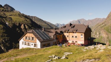
The five-day Kaunergrat Hike aimed at for advanced and expert hikers is a special experience. Taking in over 70 kilometres and 4,900 vertical metres, it leads through the heart of the Kaunergrat Nature Park. Right at the start of the adventure we recommend a quick visit to the Nature Park House at Gacher Blick, which contains exhibitions and information about the Kaunergrat Nature Park. The hike itself offers stunning views of the Kaunertal Valley and the Pitztal Valley, with liush green meadows below and the mighty glaciers of the Kaunergrat Ridge and the Ötztal Alps above. Each night is spent at a mountain hut. Most of the hiking is on trails rated black (difficult), though it is possible descend from each hut into the valley. With stages lasting up to nine hours, this hike requires good fitness, sure footing and the right equipment.

Long-Distance Hiking Trail
Starting point
Kaunergrat Nature Park House, Fließ
Finishing point
Kaunergrat Nature Park House, Fließ
Mountain chain
Ötztal Alps
Length
68.7 km
Duration
5 day(s)
Features
- Wheelchair-accessible Hiking Route
- Circular hike
Difficulty rating
difficult (black trails)
Altitude
Elevation uphill 4,873m
Vertical metres downhill 4,873m
Fitness level
Technique
Best time of year
* These are approximate values and recommendations. Please take your personal fitness level, technical ability and the current weather conditions into account. Tirol Werbung cannot guarantee that the information provided is correct and accepts no liability.
Public transport
- Accessible using public transport
Parking
Kaunergrat Nature Park House
Places serving food & drink:
Stage 1:
- Aifner-Alm (mid-May until October)
- Falkaunsalm (mid-June until mid-October)
- Gallruthalm (early June until mid-September)
- Verpeilhütte (mid-June until late September)
Stage 2:
- Kaunergrathütte (mid-June until mid-September)
Stage 3:
- Arzler Alm (first half of June until mid-September)
- Tiefentalalm (early June until the second half of September)
Stage 4:
- Neubergalm (mid-June until mid-September)
- Mauchele Alm (early June until late September)
- Söllbergalm (early June until mid-September)
Stage 5:
- Falkaunsalm (mid-June until mid-October)
- Aifner-Alm (mid-May until October)
- Café-Restaurant Gachenblick (early June until late October)
Downloads
Trail description
Stage 1: Kaunergrat Nature Park House - Verpeilhütte
Vertical ascent/descent: 1,485/1,050 metres, walking time: 9 hours, distance: 21.3 kilometres, highest point: 2,265 metres
Stage one is the touhghest of them all, so be ready for a long but beautiful day in the mountains. From the Nature Park House, head up to the Aifner-Alm hut (1.5 hours), then on to the Falkaunsalm hut (2.5 hours), the Gallruthalm (1 hour) and the idyllic Verpeilhütte hut (4 hours) at 2,025 metres above sea level, where you will stay the night. The hiking is tough but the rewards are more than ample. Highlights include the Dr.-Angerer-Höhenweg trail, which offers fine views of many mountains including the Kleiner and Großer Dristkogels and the Gsallkopfs.
Stage 2: Verpeilhütte - Kaunergrathütte
Vertical ascent/descent: 1,062/263 metres, walking time: 4.5 hours, distance: 5.4 kilometres, highest point: 3,036 metres
This fascinating stage leading through high alpine terrain leads from the Verpeilhütte hut to the Madatschjoch ridge (3.5 hours) and from there on to the Kaunergrathütte hut (1 hour), where hikers stay the night at 2,817 metres above sea level. Among the highlights is the Apere Madatschjoch ridge at over 3,000 metres and the first view of the imposing Watzenspitze with its hanging glacier.
Stage 3: Kaunergrathütte - Tiefentalalm
Vertical ascent/descent: 529/1,456 metres, walking time: 6.5 hours, distance: 14.1 kilometres, highest point: 2,944 metres
This stage begins with a climb, then descends down into the realm of lush green meadows. From the Kaunergrathütte hut, take the Pitztaler Almenweg trail to the Steinbockjoch ridge, then on to the Mittelberglesee lake, Neururer Berg mountain, Arzler Alm hut and Tiefentalalm hut. The Tiefentalalm hut is a good place to stay the night, though there is also accommodation available at the Neubergalm and in the village of Piösmes Hikers staying the night in Piösmes will have the same walking time as those who sleep at the Tiefentalalm hut. Hikers who stay at the Neubergalm hut will have to walk for around an hour more. This stage offers majestic views of the Hohe Geige mountain as well as the Pitztal and Ötztal glaciers. The beautiful Mittelberglesee lake is a good place to take a break. Keep your eyes open for chamoix.
Stage 4: Tiefentalalm - Söllbergalm
Vertical ascent/descent: 650/681 metres, walking time: 4 hours 45 minutes, distance: 9.1 kilometres, highest point: 2,247 metres
This stage is a good mix of up and down. From the Tiefentalalm hut, hikers head via the Neubergalm to the Mauchele Alm (3 hours), then on to the Söllbergalm (those who elect to stay the night in Piösmes will need an extra hour to get to the Tiefentalalm; the hiking time for those who sleep at the Neubergalm hut is only four hours to the Söllbergalm.). An ideal place for a rest on this stage is below the Stallkogel mountain with fine views of the Pitztal glaciers.
Stage 5: Söllbergalm - Naturparkhaus Kaunergrat
Vertical ascent/descent: 1,147/1,421 metres, walking time: 8.5 hours, distance: around 18.8 kilometres, highest point: 2,761 metres
The fifth and final stage has almost equal amounts of climbing and descending, though more than 1,000 vertical metres up and down means a challenging day awaits. The hike begins at the Söllbergalm hut and leads along a trail in a southerly direction to two idyllic lakes: the Brechsee and the Krummer See at 2,584 metres above sea level. After crossing the Falkaunsjoch ridge (2,761 metres) hikers descend into the Kaunertal Valley via Rossboden to the Falkaunsalm hut. From there, all that remains is to take the same route on day one, albeit in the opposite direction, via the Aifner-Alm back to the starting point of the hike, the Kaunergrat Nature Park House.


