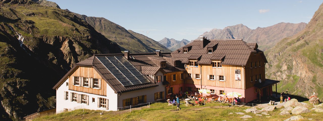
Intimate ice is what this two-day trek of intermediate difficulty is all about. Easily one of the most rewarding hikes in the area, it is filled with diverse delights and many natural wonders along the way. From Mandarfen, the adventure beings with a ride on the Riffelseebahn gondola to its top at 2,300 metres. Beneath the top terminal is where you will find the glacier-fed Rifflsee lake, the largest lake in the Ötztal Alps. Lush meadows and pink alpine roses form a charming foreground for the mighty glaciers on the horizon. The Taschachhaus at auf 2,434 metres is a good place to stop for a rest to enjoy the fine views of the Taschachferner glacier. After spending the night in Mittelberg (1,736 metres) day two showcases the contrast between the lush meadows of the Alps and the inredible power of water. From the flat, green area at the end of the Pitztal Valley, hikers pass the Pitze river and proceed to the 2,759-metre-high Braunschweiger Hütte. The final section of this stage leads through the verdant Rettenbachtal Valley. At the toll station in Sölden you can either take a pre-ordered taxi or continue on foot down to Sölden hinunter. This trek requires good overall fitness, sure footing and a good head for heights.

Starting point
Mandarfen
Finishing point
Sölden
Mountain chain
Ötztal Alps
Length
31.1 km
Duration
2 day(s)
Features
- Wheelchair-accessible Hiking Route
- Circular hike
Difficulty rating
intermediate (red mountain trails)
Altitude
Elevation uphill 1,780m
Vertical metres downhill 2,018m
Fitness level
Technique
Best time of year
* These are approximate values and recommendations. Please take your personal fitness level, technical ability and the current weather conditions into account. Tirol Werbung cannot guarantee that the information provided is correct and accepts no liability.
Public transport
- Accessible using public transport
Parking
Parking in Mandarfen, bottom of Rifflseebahn cable car
Places serving food & drink
- Stage 1: Taschachhaus (mid-June until September), Taschachalm (June until September), Berghof Steinbock in Mittelberg
- Stage 2: Gletscherstube (mid-May until October), Braunschweiger Hütte (mid-June until September), Rettenbachalm (open in summer), Gasthof Grauer Bär, Gasthof Brückenwirt and other locations in Sölden
Downloads
Trail description
Stage 1: Mandarfen – Mittelberg
Uphill/downhill: 441/986 vertical metres, walking time: 6 hours, distance: 17.1 kilometres, highest point: 2,578 meters, difficulty: intermediate
Take a ride on the Rifflsee gondola from Mandarfen. From there, follow signs for “Fuldaer Höhenweg” high-altitude trail and walk down along a dirt road to the southern shores of the Rifflsee lake at the Grubenkopfbahn. Cross the Seebach stream and follow the slightly ascending trail (“Fuldaer Höhenweg”). The route runs along the Fuldaer Höhenweg trail as far as the Taschachhaus lodge and leads into the valley across the tussock slopes northwest of the Taschachtal Valley (gentle climb with one short downhill section). Having crossed the Vorderer Eiskastenbach stream, the trail takes you through a short, steep and rugged section that is assisted by a fixed anchoring system of cables. Continue in the same direction (a bypass trail branches off to the right). After this section, the trail takes you downhill, crosses the Hinterer Eiskastenbach stream and the slope down to the valley floor. Head over bridge and walk up to the Taschachhaus lodge. From there, proceed downhill and out of the valley, walking along the glacier’s lateral moraine. The trail later crosses the stream and takes you out of the valley. When reaching the base terminal of the small cable car used to transport materials and provisions up to the hut, change to the right bank of the Taschachbach stream. Follow the slightly descending dirt road in the unwooded Taschachtal Valley, walking along the stream until the bridge right below the serviced Taschalm hut (1,796 metres). Take the trail on the right towards Mittelberg, which leads you through groves and then down to Berghof Steinbock mountain inn in Mittelberg (1,736 metres).
Stage 2: Mittelberg – Sölden
Uphill/downhill: 1,339/1,032 vertical metres, walking time: 8 hours, distance: 14 kilometres, highest point: 2,996 metres, difficulty: intermediate
From the end of the Pitztal Valley road in Mittelberg (near the Gasthof Steinbock), walk along the very slightly ascending forest/dirt road next to the Pitze river across the open alpine meadows into the valley. The dirt road passes by the Gletscherstübele mountain inn (1,915 metres) and leads to the base of a small cable car used to transport provisions and material up to the huts. This is the starting point of two trails. Take the one on the right (which runs across more scenic landscape). The trail travels along the valley floor before it reaches the valley end, from where it vigorously zigzags up through steep and rugged terrain in many switchbacks, sections of it passing by the frothing white torrents of the Pitze river as you approach the glacier snout. The trail joins the alternative route at about 2400 metres above sea level; continue walking uphill. In this section the trail leads off the brook and travels steeply up the green and flowery slope over rough and smooth terrain (many steps made of stone). The last portion of the trail even crosses rock piles and ledges before you reach the Braunschweiger Hütte. Follow the signs for “Pitztaler Jöchl” and “Sölden”; walk down a few metres and continue uphill across the steep tussock slope (past the fork towards the new route of the Mainzer Höhenweg high-altitude trail). Here it is worth taking a detour to the top of the Karleskopf mountain (2,901 metres). Proceed along a short section with scree slopes that is assisted by a fixed anchoring system of cables to gain the Pitztaler Jöchl col (2,996 metres). On the rocky descent from the col to the left you will pass towering rock cliffs and glacial fields. On your way to the car park of the Ötztal Glacier Road you will go past the fork towards the old route of Mainzer Höhenweg high-altitude trail. From the car park walk down the road and pass the base and the fork branching off to Tiefenbach glacier. Right after the fork, turn right onto the trail to “Rettenbachalm” at 2,145 metres (take a shortcut on the trail which crosses the switchbacks of the road and leads past the chapel). The path now travels out of the Rettenbach Valley on a descending slope, joins the valley floor and eventually crosses the Rettenbach river. Stay on the right bank of the brook, following a dirt road down through the unwooded valley. Finally, walk a few metres along the road towards the bus stop at the toll gate, where you can take a taxi down to the village centre of Sölden or proceed on foot (around 1.5 hours).
Return bus journey: Take the bus from Sölden to Imst and then on to Mandarfen / bottom of the cable car at Rifflsee.


