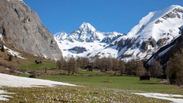
This hike in the Hohe Tauern National Park leads through the idyllic Debanttal Valley with thick pine forests to one of the most beautiful mountain lakes in the Schober massif. The history of the Trelebitschsee lake, surrounded on all sides by high mountains, dates back to the Ice Age. Hikers may well see marmots and chamoix as they make their way through the valley, of even a golden eagle. Waterfalls above and below the Trelebitschalm hut as well as fine views of the Sattelköpfe peaks make for a truly breathtaking hiking experience.

Mountain Hike
Starting point
Car park, Seichenbrunn
Hike to
Trelebitschsee lake
Finishing point
Car park, Seichenbrunn
Mountain chain
Schober Mountains
Length
6.8 km
Total hiking time
4 h 30 min
Features
- Wheelchair-accessible Hiking Route
- Circular hike
Difficulty rating
intermediate (red mountain trails)
Altitude
Elevation uphill 700m
Vertical metres downhill 700m
Fitness level
Technique
Best time of year
* These are approximate values and recommendations. Please take your personal fitness level, technical ability and the current weather conditions into account. Tirol Werbung cannot guarantee that the information provided is correct and accepts no liability.
Public transport
- Accessible using public transport
Parking
Seichenbrunn car park
Places serving food & drink:
none along the way; various locations in Nußdorf-Debant
Downloads
Trail description
The hike begins at the Seichenbrunn car park in the Debanttal Valley, at 1,666 metres above sea level. Drive from Nußdorf-Debant near Lienz on the "Alt-Debant-Straße" road via Obernußdorf along the banks of the Debantbach river for around 13.5 kilometres into the valley. At the start of the car park there is a narrow trail heading left into the forest. Follow this trail up towards the Trelebitschalm at almost 2,000 metres, which you will reach after a series of corners. Via meadows and then more rocky terrain you continue north of the Sattelköpfe upwards to the Trelebitschsee lake at 2,336 metres above sea level.
Follow the same route back to the car park.


