
Opening hours:
open
Difficulty:
medium
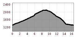
Length:
9.6 km
Elevation uphill:
12 m
The Brenner border ridge extends between Wechseljoch and Sattelberg in the Wipptal.
The tour to the Brenner border ridge starts in Brennerbad. First up the forest road to about 2150 m, where the Brennergrenzkamm trail begins. Continue almost level on path no. 1 towards Steinjoch. Soon turn right onto trail nr.3, which leads to the Steinalm. A little further on a steep forest road turns right and brings the biker down to the Brenner state road. On this road back to Brennerbad.
To avoid the descent along the steep forest road, you can also take path no. 3B - later no. 1 - to Brenner. A somewhat more demanding but rewarding trail - last section very steep.


")
")
.jpg")


Andi Frank (247).jpg")
Erwin Haiden, bikeboard.at.jpg")


-min.jpg")


