Arrival by public transport
bus: Hopfgarten Berglift
train: Hopfgarten Berglift
Guest card = travel ticket - bus & train included!
Online timetables:
www.vvt.at
www.oebb.at
Racing bike tour around the Hohe Salve
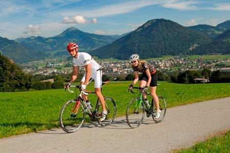
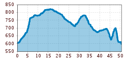
The starting point of this route is the information office in Hopfgarten. From there you cycle along the Brixentalerstraße in the direction of Westendorf, after the second railroad underpass you turn right into Untewindau. At Lendwirt keep left and cycle uphill towards Westendorf. From Westendorf you cycle along the cycle path to Kirchberg, where you continue on the main road. Shortly before Kitzbühel you turn left to Reith and follow the road until you reach Going. Via the villages of Ellmau, Scheffau and Söll, you reach Itter. You return to the starting point via Itter.
bus: Hopfgarten Berglift
train: Hopfgarten Berglift
Guest card = travel ticket - bus & train included!
Online timetables:
www.vvt.at
www.oebb.at
P3 Wasserfeld car park Hopfgarten - free of charge
cable car car park (free with lift ticket)


")

_FULL110.jpg")


")


")


