

Opening hours:Today closed
Place:Sölden
:Alpine pasture / hut / mountain restaurant, Bar / Pub
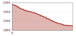
Short trail from Sonnblick to the Gampe Alm junction technically demanding

Gear Up Rules! We recommend wearing BIKE REPUBLIC SÖLDEN bike protection (elbow pads, knee pads, helmet, back protector, ...) on all lines, trails, enduro routes, and mountain bike routes. Move within the republic only with a bike that meets current quality standards.
The super flowy trail starts on a hillside ridge, where you only have to watch out for cows and hikers. At the end, there is a technically challenging section with tight hairpin turns, some of which have rain channels dug into them.
Arrival by train
Travel comfortably and safely by train to the Ötztal train station. A scheduled bus leaves directly from the station forecourt towards Obergurgl. The bus ride to Sölden takes about 1 - 1.5 hours.
All important information about bus schedules, connections, and taxi companies can be found here.
WHERE IS SÖLDEN?
Sölden is located in western Austria in the federal state of TYROL, in a southern side valley of the Inn valley – the ÖTZTAL.
Arrival from the west:
from Vorarlberg to Tyrol via the Arlberg Pass or through the Arlberg Tunnel (S 16) - Landeck - motorway A 12 towards Innsbruck - exit Ötztal after Roppener Tunnel - B 186 (35 km) to Sölden
From the north:
- Bad Tölz - Achensee - B 181 - Jenbach - A 12 Innsbruck towards Bregenz - exit Ötztal - B 186 (35 km) to Sölden
- Pfronten - Reutte - Fern Pass - Imst - A 12 towards Innsbruck - exit Ötztal after Roppener Tunnel or B 171 Tiroler Straße to Ötztal (no vignette) - B 186 (35 km) to Sölden
- Garmisch Partenkirchen - Ehrwald - Lermoos - Fern Pass - Imst - A 12 towards Innsbruck - exit Ötztal after Roppener Tunnel or B 171 Tiroler Straße to Ötztal (no vignette) - B 186 (35 km) to Sölden
- Garmisch Partenkirchen - Mittenwald - Scharnitz - Seefeld in Tirol - Telfs - A 12 towards Bregenz - exit Ötztal or B 171 Tiroler Straße to Ötztal (no vignette) - B186 (35 km) to Sölden
From the east:
from Munich or Salzburg on the A 93 to Kufstein, then on A 12 towards Bregenz, via Innsbruck to the exit Ötztal, then continue on B 186 (35 km) to Sölden
From the south:
coming from Bolzano towards Brenner (toll road) - Brenner motorway via Schönberg toll station towards Innsbruck - from Innsbruck on A 12 towards Bregenz to the Ötztal entrance - continue on B 186 (35 km) to Sölden
At the valley stations of the Gaislachkoglbahn and Giggijochbahn, sufficient parking spaces are available, including parking garages.Parking spaces are subject to charges.
Paid overnight parking of cars is possible in the Gaislachkogl parking garage:


