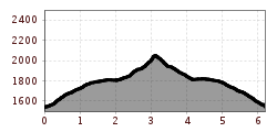
Open interactive mapOpen this POI on the interactive mapElevation profileDownloadDurch das Raintal.gpx
Sonnenalm © Sonnenalm SonnenalmOpening hours:Open todayPlace:Grän:Alpine pasture / hut / mountain restaurantsee restaurant detailssee restaurant details: Sonnenalm
KAT BIKE Kitzbüheler Alpen © Erwin Haiden KAT Bike Sport+ Stage 3: Oberndorf - Fieberbrunn without WinterstelleralmDifficulty:difficultLength:68.0 kmDuration:5:45 hElevation uphill:1,825 mGo to biketourGo to biketour: KAT Bike Sport+ Stage 3: Oberndorf - Fieberbrunn without Winterstelleralm
SchönkahlerDifficulty:mediumLength:12.4 kmDuration:5:30 hElevation uphill:798 mSee trailSee trail: Schönkahler
Vilsalpsee loop trailDifficulty:mediumLength:13.4 kmDuration:2:45 hElevation uphill:173 mGo to Cross-country skiing trailGo to Cross-country skiing trail: Vilsalpsee loop trail
Am Ponten auf über 2000 m. © grenzgaenger-wandern.com Grenzgänger - Hochalpiner Etappenwandersteig im AllgäuDifficulty:difficultLength:85.1 kmDuration:35:00 hElevation uphill:6,805 mSee trailSee trail: Grenzgänger - Hochalpiner Etappenwandersteig im Allgäu
Circular hiking trail Tannheimer Tal Route No. 1Difficulty:difficultLength:43.2 kmDuration:10:00 hElevation uphill:698 mSee trailSee trail: Circular hiking trail Tannheimer Tal Route No. 1
TVB Bike 195.jpg © Nikola Radovic - NKLRDVC Photo Wetterstein Trail blue/easy - Blue BirdOpening hours:openDifficulty:easyLength:4.1 kmGo to biketourGo to biketour: Wetterstein Trail blue/easy - Blue Bird
Grenzgänger Stage 1 - Bschießer, Ponten, Zirleseck and Willersalpe - HintersteinDifficulty:mediumLength:13.0 kmDuration:7:00 hElevation uphill:1,054 mSee trailSee trail: Grenzgänger Stage 1 - Bschießer, Ponten, Zirleseck and Willersalpe - Hinterstein
Gräner Höhenweg circular hike (awarded the Tyrolean Mountain Trail quality seal)Difficulty:difficultLength:12.8 kmDuration:5:20 hElevation uphill:934 mSee trailSee trail: Gräner Höhenweg circular hike (awarded the Tyrolean Mountain Trail quality seal)
Grenzgänger Stage 5 - Hinterhornbach, Hochvogel & Hintersteiner TalDifficulty:difficultLength:14.4 kmDuration:7:30 hElevation uphill:1,251 mSee trailSee trail: Grenzgänger Stage 5 - Hinterhornbach, Hochvogel & Hintersteiner Tal
Grenzgänger Stage 3 - Via the Jubilee Trail to the Prinz-Luitpold HouseDifficulty:mediumLength:12.3 kmDuration:6:00 hElevation uphill:745 mSee trailSee trail: Grenzgänger Stage 3 - Via the Jubilee Trail to the Prinz-Luitpold House
450 - SchönachtalDifficulty:easyLength:11.1 kmDuration:1:30 hElevation uphill:213 mGo to biketourGo to biketour: 450 - Schönachtal
Theme Trail "Holzweg" (Zellberg)Difficulty:easyLength:4.0 kmDuration:2:00 hElevation uphill:290 mSee trailSee trail: Theme Trail "Holzweg" (Zellberg)
TVB Bike 204.jpg © Nikola Radovic - NKLRDVC photo Wetterstein trail red - Fifty/FiftyOpening hours:openDifficulty:mediumLength:1.2 kmGo to biketourGo to biketour: Wetterstein trail red - Fifty/Fifty
Tuxerjoch_Biketrail_LO-99.jpg © Johannes Sautner Hintertux - Bichlalm - TuxerjochDifficulty:mediumLength:9.0 kmDuration:2:30 hElevation uphill:848 mGo to biketourGo to biketour: Hintertux - Bichlalm - Tuxerjoch
Langlaufen in Serfaus-Fiss-Ladis.jpg © © Serfaus-Fiss-Ladis Marketing GmbH Cross-country skiing at Lake Wolfsee in FissOpening hours:closedDifficulty:easyLength:1.5 kmElevation uphill:29 m:Style: Skating, ClassicGo to Cross-country skiing trailGo to Cross-country skiing trail: Cross-country skiing at Lake Wolfsee in Fiss
Unterwegs auf dem Six-Senses-Weg © © Serfaus-Fiss-Ladis Marketing GmbH Six Senses trailOpening hours:closedDifficulty:easyLength:5.7 kmDuration:4:00 hElevation uphill:10 mGo to winter hikeGo to winter hike: Six Senses trail
Fliegender Wasserhahn.jpg © Johannes Sautner, shootandstyle.com Tux River Adventure Footpath - Along the Tux riverDifficulty:easyLength:10.2 kmDuration:3:00 hElevation uphill:356 mSee trailSee trail: Tux River Adventure Footpath - Along the Tux river
Waterfall TrailDifficulty:mediumLength:3.5 kmDuration:2:00 hElevation uphill:260 mSee trailSee trail: Waterfall Trail
Hundalmjoch © Ferienregion Hohe Salve Hike to the HundalmjochDifficulty:mediumDuration:7:00 hElevation uphill:993 mSee trailSee trail: Hike to the Hundalmjoch
Arbiskogel - KirchspitzeDifficulty:difficultLength:17.0 kmDuration:7:15 hElevation uphill:1,616 mSee trailSee trail: Arbiskogel - Kirchspitze
Schwarzachtal - Nr. 8Difficulty:easyLength:2.0 kmDuration:1:50 hElevation uphill:172 mSee trailSee trail: Schwarzachtal - Nr. 8
Along the Vilsalpsee to the Bergacht WaterfallDifficulty:easyLength:6.5 kmDuration:1:30 hElevation uphill:99 mSee trailSee trail: Along the Vilsalpsee to the Bergacht Waterfall
EinsteinDifficulty:mediumLength:14.0 kmDuration:6:00 hElevation uphill:876 mSee trailSee trail: Einstein
BannwaldseerundeDifficulty:mediumLength:95.4 kmDuration:3:45 hElevation uphill:591 mGo to biketourGo to biketour: Bannwaldseerunde
Give feedback for a chance to win a special holiday experience!Click here for the surveyClick here for the survey