Long-distance hike Carnic altitude trail. Stage 1: Arnbach - Sillianer Hütte

Difficulty ratings: easy
Route length: 9.5 km

The Carnic High Trail adventure gets off to a brilliant start today. The panorama takes our breath away at times. Well, maybe it's because of the hairpin bends we're winding our way up and a little bit because of the altitude: the Sillianer Hütte is situated at 2,447 m above sea level. Once at the top, we take in the spectacular view and say goodbye to the day's guests. Because: we are staying.

Tour character

Difficult stage on black mountain paths. The route requires absolute surefootedness, good walking technique and excellent fitness.

Tour information

  • Requirement: easy
  • Length: 9.5 km
  • Elevation uphill:1,350 hm
  • Elevation downhill:0 hm
Highest point2,447 m

Starting point

Dorfzentrum Sillian

Finishing point

Sillianer Hütte
Source: TVB Osttirol

Description


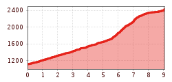
The official entry point to the Carnic altitude trail proceeds from Alpenhotel Weitlanbrunn (the hamlet of Arnbach) initially via a wide forest trail, in flat hairpin bends up to 1660 m. Leave the trail here, bearing left. From "Hofer Bankl" the Carnic altitude trail is then also the route of the local trail. Follow the trail to the forest limits and continue to Sillianer Hütte.

Further ascent options to Sillianer Hütte:
1) Via route 471 and Leckfeldalm (4 hours walking time from Sillian, 2 hours walking time from Leckfeldalm)
2) Take the Vierschach cable car via Helm (2 hours walking time from Helm mountain station)

Nearby huts and mountain restaurants

More tours in the surrounding area

  • Kundler Klamm

    Opening hours: closed
    Difficulty: easy
    Length: 6.4 km Duration: 2:00 h Elevation uphill: 116 m
  • Kaiser Gorge - loop trail

    Opening hours: closed
    Difficulty: easy
    Length: 4.2 km Duration: 1:00 h Elevation uphill: 198 m
  • 3-peak-tour Kienberg-Plessenberg-Heuberg

    Difficulty: medium
    Length: 8.6 km Duration: 4:30 h Elevation uphill: 779 m
  • 4 days - 4 summits tour

    Difficulty: medium
    Length: 54.4 km Duration: 23:00 h Elevation uphill: 3,408 m
  • Discovering the Tiefenbach Gorge Hike

    Opening hours: closed
    Difficulty: medium
    Length: 5.7 km Duration: 3:30 h Elevation uphill: 669 m
  • Voldöpper Spitze Loop Hike

    Difficulty: medium
    Length: 12.9 km Duration: 5:00 h Elevation uphill: 988 m
  • Loop tour Juppi Zauberwald

    Difficulty: easy
    Length: 2.5 km Duration: 1:00 h Elevation uphill: 93 m
  • Day 1: 4 days - 4 summits tour

    Difficulty: medium
    Length: 9.8 km Duration: 5:00 h Elevation uphill: 984 m
  • Wheelchair Circular Hike Runst-Achweg

    Difficulty: easy
    Length: 6.3 km Duration: 2:00 h Elevation uphill: 40 m
  • Ötztal Trek Stage 4

    Difficulty: difficult
    Length: 8.9 km Duration: 4:00 h Elevation uphill: 802 m
  • Ötztal Trek Stage 3

    Difficulty: difficult
    Length: 10.4 km Duration: 4:00 h Elevation uphill: 842 m
  • Ötztal Trek Stage 8

    Difficulty: difficult
    Length: 9.3 km Duration: 3:30 h Elevation uphill: 274 m
  • Ötztal Trek Stage 1

    Difficulty: medium
    Length: 18.6 km Duration: 6:30 h Elevation uphill: 1,561 m
  • Ötztal Trek Stage 14

    Difficulty: difficult
    Length: 6.3 km Duration: 3:00 h Elevation uphill: 1,004 m
  • Ötztal Trek Stage 18

    Difficulty: difficult
    Length: 9.5 km Duration: 9:30 h Elevation uphill: 979 m
  • Ötztal Trek Stage 12

    Difficulty: difficult
    Length: 4.8 km Duration: 2:00 h Elevation uphill: 592 m
  • Ötztal Trek Stage 22

    Difficulty: difficult
    Length: 21.5 km Duration: 8:00 h Elevation uphill: 647 m
Newsletter

The mountain is calling? So does our newsletter!

In our monthly newsletter we reveal the best holiday tips for Tyrol.