
Place:
Galtür
:
Restaurant, Alpine pasture / hut / mountain restaurant
Medium difficulty hike to the Fädnerspitze mountain
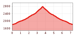
By car or by bus get to the Zeinisjoch at 1.822 m. From there hike past Alpengasthof Zeinisjoch and follow the signposts for Fädnerspitze. Climb higher on narrow paths – just beneath the summit the path becomes noticeably steeper and somewhat more exposed. At around 2.800 m you reach the summit and panoramic views to the Silvretta group, then head down to Kopsstausee. Return section: same route back.
With the railway station in Landeck, the Paznaun is optimally connected to the Austrian train network. From Landeck-Zams station, only a short bus ride separates you from the Paznaun. Every half hour, line bus 260 runs from there through the valley. Bus stop: Kops Gh Zeinisjoch
Buses in the Paznaun valley | Region Paznaun – Ischgl

.jpg")

.jpg")


.jpg")
.jpg")


