Mountain hikes Großvenediger 3.657 m (Aufstieg über Gschlösstal

Matrei in Osttirol / Venedigergruppe
Difficulty ratings: difficult
Route length: 8.3 km
Duration: 5:30 h

Breathtaking path to "world-old majesty"

Tour information

  • Requirement: difficult
  • Length: 8.3 km
  • Duration: 5:30 h
  • Elevation uphill:930 hm
  • Elevation downhill:930 hm
Highest point3,657 m

Starting point

Hut Neue Prager Hütte

Finishing point

Hut Neue Prager Hütte
  • Fitness level 6 / 6
  • Technique 5 / 6

Best time of year

  • January
  • February
  • March
  • April
  • May
  • June
  • July
  • August
  • September
  • October
  • November
  • December

Equipment

Ascent with mountain guide recommended!
Source: TVB Osttirol

Description

The tour starts at the Matreier Tauernhaus and leads first via hiking trail no. 925 or the wide road to Innergschlöß. This section can also be done with the Gschlösser Panoramazug or by taxi. At the end of the valley, the ascent to the Neue Prager Hütte begins. Take trail no. 902b and 902 and after about 1 hour you will reach the Alte Prager Hütte. This hut is no longer managed and has been converted into a museum. After another hour's walk, you come to the Neue Prager Hütte, which serves as an overnight accommodation. 
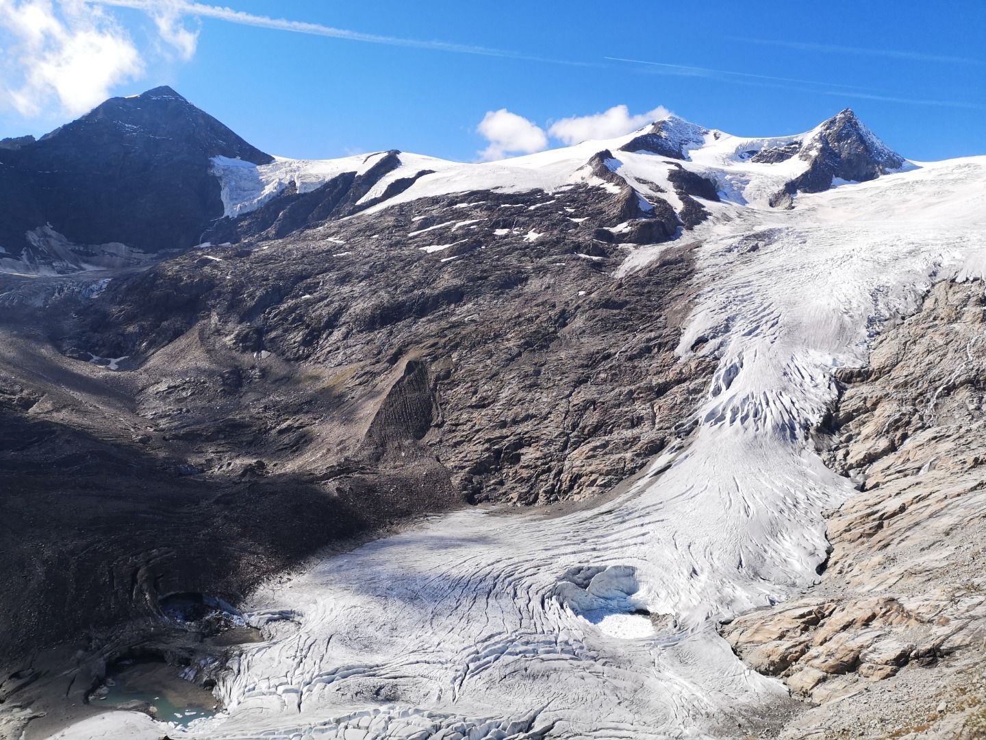
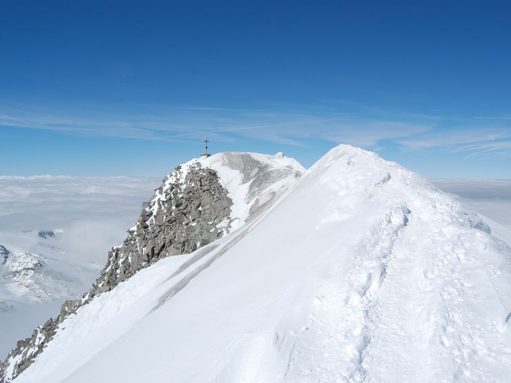
The ascent to the summit takes place over a crevasse-rich glacier area and requires essential glacier equipment. The ascent with a mountain guide is highly recommended!

Nearby huts and mountain restaurants

More tours in the surrounding area

  • Hike to the Venedigerhaus Innergschlöß

    Difficulty:easy
    Length:8.6 kmDuration:2:30 hElevation uphill:184 m
  • Lucknerhaus - Stüdlhütte

    Difficulty:medium
    Length:9.3 kmDuration:5:30 hElevation uphill:862 m
  • Badener Hütte

    Difficulty:difficult
    Length:23.2 kmDuration:11:30 hElevation uphill:1,754 m
  • Theme path "Virgen crossroads"

    Difficulty:easy
    Length:3.2 kmDuration:1:00 hElevation uphill:104 m
  • Venediger altitude trail

    Difficulty:difficult
    Length:55.5 kmDuration:27:00 hElevation uphill:3,915 m
  • Lasörling altitude trail

    Difficulty:medium
    Length:57.0 kmDuration:25:00 hElevation uphill:3,740 m
  • Figerhorn

    Difficulty:difficult
    Length:6.5 kmDuration:6:00 hElevation uphill:807 m
  • Muhs panorama trail

    Difficulty:medium
    Length:15.2 kmDuration:6:00 hElevation uphill:1,090 m
  • Böses Weibl

    Difficulty:difficult
    Length:14.1 kmDuration:8:00 hElevation uphill:1,193 m
  • Umbal waterfalls nature force trail

    Difficulty:easy
    Length:6.0 kmDuration:2:30 hElevation uphill:257 m
  • Hike to Kalser Tauernhaus

    Difficulty:medium
    Length:12.2 kmDuration:4:00 hElevation uphill:244 m
  • Hiking tour to Neue Sajathütte 2.600m

    Difficulty:medium
    Length:10.3 kmDuration:6:50 hElevation uphill:1,086 m
  • Hike to Neuen Reichenberger Hütte

    Difficulty:medium
    Length:18.2 kmDuration:9:00 hElevation uphill:1,252 m
  • Hiking tour to Lasörlinghütte 2.350m

    Difficulty:medium
    Length:14.6 kmDuration:7:10 hElevation uphill:1,080 m
  • Rotenkogel

    Difficulty:difficult
    Length:3.9 kmDuration:3:00 hElevation uphill:383 m
  • Lasörling 3.098m

    Difficulty:difficult
    Length:21.9 kmDuration:12:00 hElevation uphill:1,940 m
  • Rollitour with Swiss Trac

    Difficulty:easy
    Length:3.2 kmDuration:1:30 hElevation uphill:135 m
  • Eagle Walk Stage O1: Ströden - Johannis Hütte

    Difficulty:medium
    Length:13.0 kmDuration:6:30 hElevation uphill:1,430 m
Newsletter

The mountain is calling? So does our newsletter!

In our monthly newsletter we reveal the best holiday tips for Tyrol.