Description
Starting point: Roppen: on the left bank of the Inn
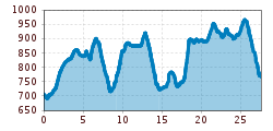
Length: 25.4 km - Time required: 7:30
Altitude ascent: 476m - altitude descent: 429m
Max. Height: 931 m.ü.M.
From the direction of Haiming on the right side of the Inn - hiking trail on Inn (Inntalradweg) - «Römerbadl» Kneippanlage - Burschlkapelle - right underpass federal road 171 - rise Trankhütte - through the forest to Karres - past the sports field - Karres St. Stephen Church - after the municipal office turn right after Karrösten - turn off the VARIANT to Imst - Karröster road down to the Royal Chapel - south over the Inn bridge - keep right - past the substation power station to the train station Imster Au - left next to the railway line to the trunk stream - Ried - Schönwies - above Schönwies im Obsaurs district is the St. Vigil Chapel - continue towards Kronburg after about 1 hour you reach the ruin Kronburg.
Further information and details can be found at http://www.jakobsweg-tirol.net/