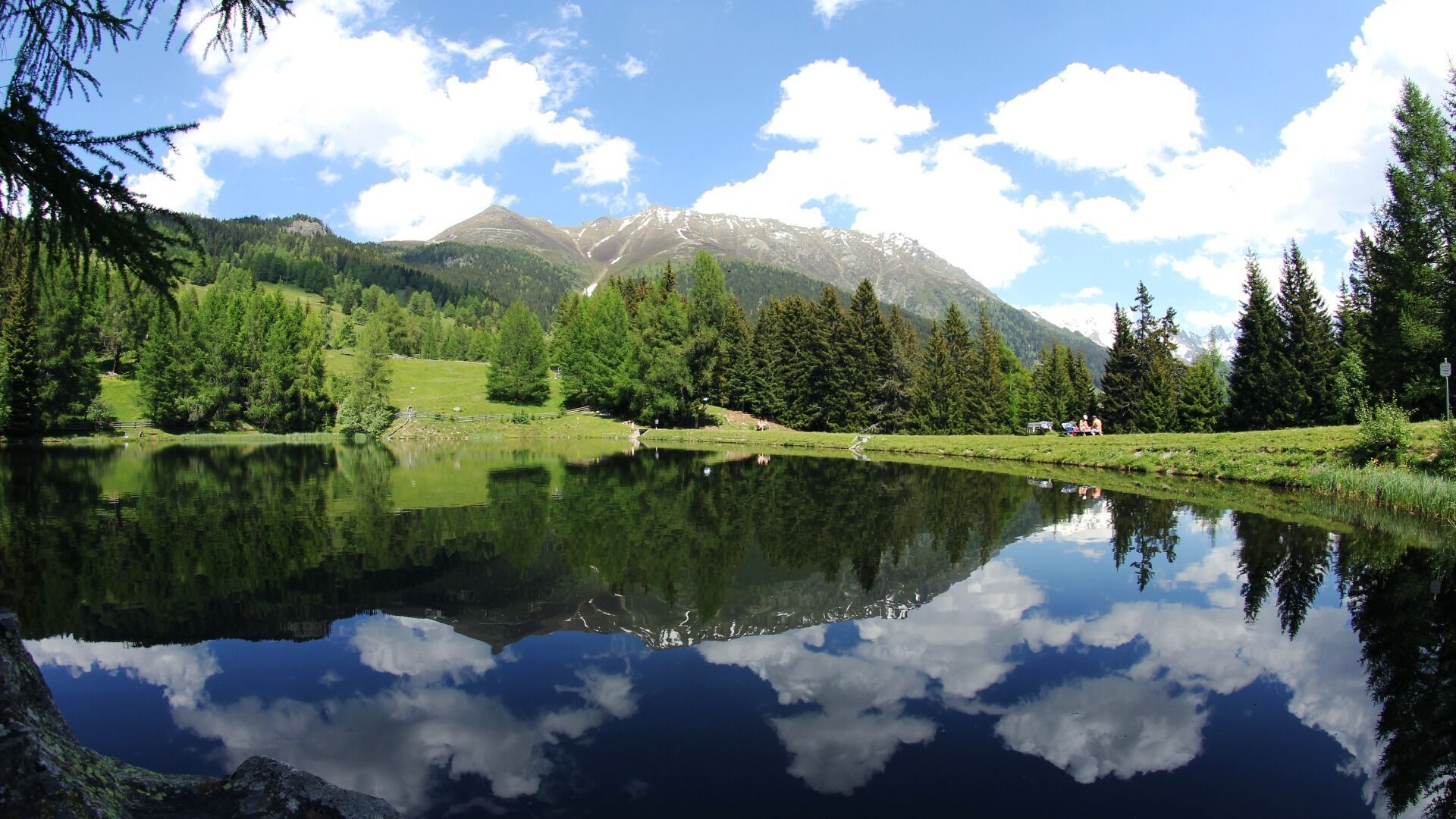
Herrliche Rundwanderung mit beeindruckenden Blicken ins Kaunertal und Inntal - inmitten traditioneller Kulturlandschaft.
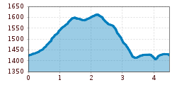
Open interactive mapOpen this POI on the interactive mapElevation profiledownloadRundwanderung Schnadiger Weiher.gpx
Geraerhütte_JohannesBitter_TVB-Wipptal_170623_105.jpg © JOHANNES BITTER Hike to the Geraer Hütte | Austrian TyrolDifficulty:mediumLength:7.0 kmDuration:5:30 hElevation uphill:1,000 mSee trailSee trail: Hike to the Geraer Hütte | Austrian Tyrol
valentinkapelle-1.jpg © Archiv TVB Mayrhofen Mountain hike: Zillergrund - Valentins KapelleDifficulty:mediumLength:3.2 kmDuration:2:30 hElevation uphill:390 mSee trailSee trail: Mountain hike: Zillergrund - Valentins Kapelle
Round hike to Padauner KogelDifficulty:mediumLength:12.0 kmDuration:5:00 hElevation uphill:936 mSee trailSee trail: Round hike to Padauner Kogel
Lämmerbichl_Tirol Werbung_Sürth Paul_Tux-Hintertux.jpg © Sürth Paul Spring with late crocus blossom in Tux ValleyDifficulty:mediumLength:10.0 kmDuration:4:00 hElevation uphill:640 mSee trailSee trail: Spring with late crocus blossom in Tux Valley
Barrierefreier Themenweg am Schlosskopf © Inn-Frame Fotografie www.inn-frame.at Barrier-free theme trail at the castle headDifficulty:easyLength:1.0 kmDuration:0:20 hElevation uphill:26 mSee trailSee trail: Barrier-free theme trail at the castle head
Kaiserjochhaus © Lechtal Tourismus Lechtaler Höhenweg: 3. Etappe Kasierjochhaus-Ansbacher HütteDifficulty:difficultLength:7.8 kmDuration:4:45 hElevation uphill:844 mSee trailSee trail: Lechtaler Höhenweg: 3. Etappe Kasierjochhaus-Ansbacher Hütte
Kaiserjochhaus © Lechtal Tourismus Lechtaler Höhenweg: 3. Etappe Kasierjochhaus-Ansbacher HütteDifficulty:difficultLength:11.3 kmDuration:6:45 hElevation uphill:1,010 mSee trailSee trail: Lechtaler Höhenweg: 3. Etappe Kasierjochhaus-Ansbacher Hütte
Lech bei Forchach. © Lechtal Tourismus Stanzach - Over the suspension bridgeDifficulty:easyLength:12.8 kmDuration:3:15 hElevation uphill:42 mSee trailSee trail: Stanzach - Over the suspension bridge
Wildschönau Auffach Schatzberg Familienwanderung.jpg © Wildschönau Tourismus Johannes Sautner Rechte Skijuwel und Wildschönau Schatzberg and Joel SpitzeDifficulty:mediumLength:7.3 kmDuration:3:00 hElevation uphill:400 mSee trailSee trail: Schatzberg and Joel Spitze
large-Weg-der-Sinne-Pfafflar-5.jpg © Raimund Krabacher Hölltal - Trail of the Senses - Bschlaber HöhenwegDifficulty:mediumLength:7.4 kmDuration:2:45 hElevation uphill:295 mSee trailSee trail: Hölltal - Trail of the Senses - Bschlaber Höhenweg
Herrlicher Ausblick © Lechtal Tourismus PanoramawegDifficulty:mediumLength:6.6 kmDuration:3:00 hElevation uphill:470 mSee trailSee trail: Panoramaweg
The WiegalmDifficulty:mediumLength:10.5 kmDuration:4:45 hElevation uphill:680 mSee trailSee trail: The Wiegalm
Evening winter hike Kleinmutzkopf, NaudersDifficulty:easyLength:6.0 kmDuration:2:00 hElevation uphill:70 mGo to winter hikeGo to winter hike: Evening winter hike Kleinmutzkopf, Nauders
Putzen-Alm © TVB St. Anton am Arlberg Patrick Bätz St. Anton - PutzenalpeDifficulty:mediumLength:10.8 kmDuration:4:00 hElevation uphill:605 mSee trailSee trail: St. Anton - Putzenalpe
GenießerRundWeg am Ahorn © Christian Lorenz Circular & themed hike: "GenießerRundWeg" at Mount AhornDifficulty:easyLength:2.0 kmDuration:0:45 hElevation uphill:70 mSee trailSee trail: Circular & themed hike: "GenießerRundWeg" at Mount Ahorn
Muttereralm - Saile (Nockspitze)Difficulty:difficultLength:7.5 kmDuration:4:00 hElevation uphill:789 mSee trailSee trail: Muttereralm - Saile (Nockspitze)
Ackernalm Hütte Sommer © Gipfelfieber/Andreas Gruhle Up to Hinteres SonnwendjochDifficulty:mediumLength:10.9 kmElevation uphill:848 mSee trailSee trail: Up to Hinteres Sonnwendjoch
Wandern Bettlersteig Kaistertal Naturerlebnis Kaisergebirge © Thomas Laukat Kaiserlift Tourentipp 5: From Brentenjoch into the Kaiser ValleyDifficulty:difficultLength:17.6 kmElevation uphill:425 mSee trailSee trail: Kaiserlift Tourentipp 5: From Brentenjoch into the Kaiser Valley
Winter walk Schwarzer See, NaudersDifficulty:easyLength:10.5 kmDuration:3:30 hElevation uphill:255 mGo to winter hikeGo to winter hike: Winter walk Schwarzer See, Nauders
Hermann v. Barth Hütte © Lechtal Tourismus Elbigenalp - Hermann v. Barth HütteDifficulty:mediumLength:6.7 kmDuration:3:50 hElevation uphill:1,062 mSee trailSee trail: Elbigenalp - Hermann v. Barth Hütte
Rundwanderung um den PlanseeDifficulty:mediumLength:14.6 kmDuration:3:30 hElevation uphill:85 mSee trailSee trail: Rundwanderung um den Plansee
Hochalm Sommer Außenansicht © Hochalm Berwang circular hike AlmkopfDifficulty:easyLength:8.9 kmDuration:3:30 hElevation uphill:466 mSee trailSee trail: Berwang circular hike Almkopf
Summit hike Salfainssee - Schaflegerkogel (2,405 m) - Kemater Alm mountain hutDifficulty:mediumLength:14.8 kmDuration:7:00 hElevation uphill:1,029 mSee trailSee trail: Summit hike Salfainssee - Schaflegerkogel (2,405 m) - Kemater Alm mountain hut
2015_1046.jpg © Innsbruck Tourismus / Moser Grünberg - Simmeringalm mountain hutDifficulty:mediumLength:6.4 kmDuration:3:30 hElevation uphill:781 mSee trailSee trail: Grünberg - Simmeringalm mountain hut
Stöttlalmbrücke circular hikeDifficulty:easyLength:8.7 kmDuration:2:30 hElevation uphill:117 mSee trailSee trail: Stöttlalmbrücke circular hike
Give feedback for a chance to win a special holiday experience!Click here for the surveyClick here for the survey


.jpg")


.jpg")


.jpg")


