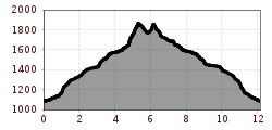
Open interactive mapOpen this POI on the interactive mapElevation profiledownloadWanderung zum Kuhkarjoch.gpx
Barrierefreier Themenweg am Schlosskopf © Inn-Frame Fotografie www.inn-frame.at Barrier-free theme trail at the castle headDifficulty:easyLength:1.0 kmDuration:0:20 hElevation uphill:26 mSee trailSee trail: Barrier-free theme trail at the castle head
Pfad zur Dürrenberg Alm © Rene Paulweber Koflerjoch summit hikeDifficulty:difficultLength:9.3 kmDuration:4:45 hElevation uphill:933 mSee trailSee trail: Koflerjoch summit hike
Vilser Alm © Rene Paulweber / Fotostudio Rene Vilser Alm HikeDifficulty:easyLength:6.6 kmDuration:2:45 hElevation uphill:348 mSee trailSee trail: Vilser Alm Hike
Höfener Alm © TVB Naturparkregion Reutte Hike up the HahnenkammDifficulty:mediumLength:15.4 kmDuration:5:30 hElevation uphill:968 mSee trailSee trail: Hike up the Hahnenkamm
Alpenrosenweg © TVB Naturparkregion Reutte Wheelchair-Accessible Hahnenkamm Hiking TrailDifficulty:easyLength:5.2 kmDuration:1:30 hElevation uphill:90 mSee trailSee trail: Wheelchair-Accessible Hahnenkamm Hiking Trail
Füssener Hütte © Rene Paulweber Through the Tannheim mountains | 4-day tourDifficulty:mediumLength:35.0 kmDuration:15:00 hElevation uphill:2,200 mSee trailSee trail: Through the Tannheim mountains | 4-day tour
Auf dem Jubiläumsweg, im Hintergrund der Hochvogel. © www.grenzgaenger-wandern.com Grenzgänger Stage 3 - Via the Jubilee Trail to the Prinz-Luitpold HouseDifficulty:mediumLength:12.3 kmDuration:6:00 hElevation uphill:745 mSee trailSee trail: Grenzgänger Stage 3 - Via the Jubilee Trail to the Prinz-Luitpold House
Give feedback for a chance to win a special holiday experience!Click here for the surveyClick here for the survey