

Difficulty:difficult
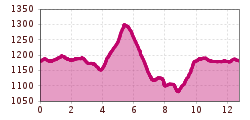
Length:7.9 kmDuration:4:15 hElevation uphill:511 m
Medium-difficulty tour from Seefeld through the Hölltal via Reith.

Route: Rückenwind Seefeld- Reither Driving Range - Römerweg - Auland - Reith - Hölltal - Rückenwind Seefeld
Directions:
Start at Rückenwind Seefeld through the village square towards Reith. Right after starting, cross the railway tracks and pass by the Reither Driving Range. After about 1 KM, turn right onto Römerweg and cross the federal road a few minutes later to enter the forest on the right. Above the village of Auland, the trail goes left up to the highest point of the route. Descending, a turn is reached that directs back towards Reith/Seefeld. At the exit of Reith, pass under the underpass and follow the trail below Seefelder Straße back to Seefeld.


