Gaiskogel

Route length: 1.5 km
Duration: 1:30 h

Gaiskogel

Tour information

  • Length: 1.5 km
  • Duration: 1:30 h
  • Elevation uphill:400 hm
  • Elevation downhill:0 hm
Highest point2,820 m

Starting point

Drei-Seen-Bahn Bergstation

Finishing point

Gaiskogel

Best time of year

  • January
  • February
  • March
  • April
  • May
  • June
  • July
  • August
  • September
  • October
  • November
  • December
Source: Innsbruck Tourismus

Description

The ski tour to the Gaiskogel in the Kühtai-Sellraintal region offers an impressive alpine experience. The starting point is at the mountain station of the Drei-Seen cable car, which makes the first part of the ascent easier. From there, the route leads through a flat cirque before a steep ascent to the Gaiskogelscharte - good hairpin bend technique and fitness are required here.

After the saddle, the route continues on foot along a narrow ridge to the summit. This section is often overgrown and requires surefootedness. Once at the top, an impressive panorama with a real Western Alps feeling rewards the effort.

More tours in the surrounding area

  • Breiteggspitze

    Difficulty:easy
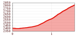
    Length:3.4 kmDuration:2:00 hElevation uphill:700 m
  • Bichalm

    Difficulty:easy
    Length:2.4 kmDuration:1:30 hElevation uphill:450 m
  • Mutterer Alm

    Difficulty:medium
    Length:3.1 kmDuration:2:00 hElevation uphill:581 m
  • Hoadl-Haus

    Difficulty:easy
    Length:7.6 kmDuration:2:25 hElevation uphill:778 m
  • Patscherkofel Schutzhaus

    Difficulty:medium
    Length:13.3 kmDuration:2:30 hElevation uphill:1,000 m
  • Eichenhof

    Difficulty:medium
    Length:4.7 kmDuration:2:50 hElevation uphill:898 m
  • Seefelder Joch

    Difficulty:medium
    Length:5.8 kmDuration:2:30 hElevation uphill:866 m
Newsletter

The mountain is calling? So does our newsletter!

In our monthly newsletter we reveal the best holiday tips for Tyrol.