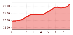
Kraspesspitze

Route length: 7.9 km
Duration: 3:30 h

Kraspesspitze

Tour information

  • Length: 7.9 km
  • Duration: 3:30 h
  • Elevation uphill:1,180 hm
  • Elevation downhill:0 hm
Highest point2,954 m

Starting point

Parkplatz Drei-Seen-Bahn Kühtai (gebührenfrei)

Finishing point

Kraspesspitze
Source: Innsbruck Tourismus

Description

The ski tour to Kraspesspitze (2,954 m) starts at the DreiSeenBahn parking lot and initially leads to the picturesque Finstertal reservoir. From there, it continues via the Finstertaler Scharte before the final, challenging ascent to the summit. With 1,180 meters of elevation gain and nearly 8 kilometers in length, this tour presents a real challenge and requires good physical condition. The descent can either follow the ascent route or alternatively head down to Haggen, providing a varied and scenic return.

More tours in the surrounding area

  • Breiteggspitze

    Difficulty:easy
    Length:3.4 kmDuration:2:00 hElevation uphill:700 m
  • Patscherkofel Schutzhaus

    Difficulty:medium
    Length:13.3 kmDuration:2:30 hElevation uphill:1,000 m
  • Eichenhof

    Difficulty:medium
    Length:4.7 kmDuration:2:50 hElevation uphill:898 m
  • Hoadl-Haus

    Difficulty:easy
    Length:7.6 kmDuration:2:25 hElevation uphill:778 m
  • Mutterer Alm

    Difficulty:medium
    Length:3.1 kmDuration:2:00 hElevation uphill:581 m
  • Bichalm

    Difficulty:easy
    Length:2.4 kmDuration:1:30 hElevation uphill:450 m
  • Seefelder Joch

    Difficulty:medium
    Length:5.8 kmDuration:2:30 hElevation uphill:866 m
Newsletter

The mountain is calling? So does our newsletter!

In our monthly newsletter we reveal the best holiday tips for Tyrol.