Schneiderscharscharte (2,027m)

Route length: 4.0 km
Duration: 2:00 h

Beautiful and very steep spring ski tour in the Nature Park Karwendel with a spectacular descent. Advanced skills for climbing steep terrain required.

Tour information

  • Length: 4.0 km
  • Duration: 2:00 h
  • Elevation uphill:770 hm
  • Elevation downhill:0 hm
Highest point2,027 m

Starting point

Pertisau, Gramai Alm

Finishing point

Pertisau, Schneiderscharscharte (2,027m)

Best time of year

  • January
  • February
  • March
  • April
  • May
  • June
  • July
  • August
  • September
  • October
  • November
  • December

Equipment

Snacks and drinks, helmet, avalanche safety gear (transceiver, shovel and probe), first aid kit, bivvy bag and mobile phone. Avalanche airbags improve your chance of survival.
Source: Achensee Tourismus

Description

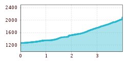
Ascent from the Gramai Alm car park (1,263 metres) in a southerly direction over the Falzthurn stream to the Gramaier Grund. At an elevation of approx. 1,500m keep to the left and climb the wide Schneiderkar in an easterly direction. At the end of the cirque, the route turns to the left, the slope gets steeper and the cirque narrows until you reach the narrow Schneiderscharscharte.  
The descent follows the ascent route.

Note: Before May, the starting point of the tour to Schneiderscharscharte is at the Karwendeltäler car park in Pertisau.

Nearby huts and mountain restaurants

  • Gramai Alm

    Opening hours:Open today
    Place:Pertisau am Achensee
    :Restaurant, Alpine pasture / hut / mountain restaurant:Breakfast, vegetarian, vegan

Getting here

  • Arrival by public transport

    Take the regional bus (line 8332 or 390) to Pertisau and get off at the "Pertisau Karwendeltäler" stop.

  • Parking

    Note: Before May, park at the Karwendeltäler car park (paid parking) in Pertisau. From May, parking is available at Gramai Alm (access via toll road).

More tours in the surrounding area

  • Breiteggspitze

    Difficulty:easy
    Length:3.4 kmDuration:2:00 hElevation uphill:700 m
  • Seefelder Joch

    Difficulty:medium
    Length:5.8 kmDuration:2:30 hElevation uphill:866 m
  • Mutterer Alm

    Difficulty:medium
    Length:3.1 kmDuration:2:00 hElevation uphill:581 m
  • Bichalm

    Difficulty:easy
    Length:2.4 kmDuration:1:30 hElevation uphill:450 m
  • Hoadl-Haus

    Difficulty:easy
    Length:7.6 kmDuration:2:25 hElevation uphill:778 m
  • Patscherkofel Schutzhaus

    Difficulty:medium
    Length:13.3 kmDuration:2:30 hElevation uphill:1,000 m
  • Eichenhof

    Difficulty:medium
    Length:4.7 kmDuration:2:50 hElevation uphill:898 m
Newsletter

The mountain is calling? So does our newsletter!

In our monthly newsletter we reveal the best holiday tips for Tyrol.