
Opening hours:Open today
Place:Sölden
:Alpine pasture / hut / mountain restaurant
SÖLDEN / GRANBICHL --> Parking lot barrier --> Kleble Alm --> Söldenkogl --> Stallwiesalm --> Parking lot barrier --> SÖLDEN GRANBICHL
Please note the current snow and avalanche report for the upcoming days:
https://www.oetztal.com/de/winter.html & https://avalanche.report/albina-web/bulletin/bulletin/bulletin/latest?lang=de
Avalanche Danger Scale
1 (LOW)
An avalanche release is only possible with heavy additional load on very few extreme steep slopes. No spontaneous avalanches (so-called slips) are expected. Generally safe conditions.
2 (MODERATE)
An avalanche release is probable with heavy additional load especially on the specified steep slopes. Larger avalanches are not expected. The snow cover is generally well consolidated except for some steep slopes. Careful route selection at specified steep slopes and aspects.
3 (CONSIDERABLE)
An avalanche release is already probable at low additional load mainly on the specified steep slopes. Occasionally some medium-sized and sporadically also large avalanches are possible spontaneously. The snow cover is only moderately to weakly consolidated on many steep slopes. Experience in avalanche assessment is necessary. Avoid specified steep slopes and aspects if possible.
4 (HIGH)
An avalanche release is already possible at low additional load mainly on the specified steep slopes. Occasionally many medium and also large avalanches occur. The snow cover is only weakly consolidated on many steep slopes. Restrict route to moderately steep terrain and pay attention to avalanche runout zones. Extensive experience in avalanche assessment is necessary.
5 (VERY HIGH)
Numerous large avalanches, even in moderately steep terrain, are expected spontaneously. At this warning level, safe operation in ski areas is no longer possible. The snow cover is generally weakly consolidated and unstable. Tour cancellations are recommended.
Recommended Ski Touring Equipment
The "normal ski touring equipment" consists of ski touring skis with touring bindings, telescopic poles, climbing skins, crampons, a digital avalanche transceiver, avalanche shovel, avalanche probe, first aid kit, and a mobile phone. A "complete glacier equipment" consists of a harness, two prusik loops or ascenders of different lengths, two HMS carabiners, an ice axe, crampons, and a rope. A backpack with appropriate contents must be carried, including spare clothing, sun protection, cold protection, food, and sufficient drinks!
DIFFICULTY RATING
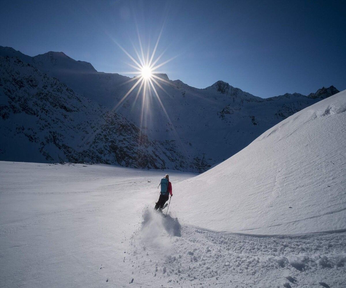
The Söldenkogel is the local mountain of Sölden and is accessible both in summer and winter. Furthermore, although it is not quite one of the 3000-meter peaks, Söldenkogl is one of the most beautiful viewpoints in Sölden.
The start is at the free parking lot by the barrier, above Sölden in the district of Granbichl.
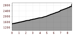
From there, you leisurely ascend on a wide, groomed forest road up to just under 2000m to Kleble Alm. From Kleble Alm, you go directly into open terrain until you reach an old stable. Continue over several rock ridges and terrain ridges up to the crest where the ski depot is located. From the ski depot, continue along the ridge to the summit cross.
The descent follows the ascent track down to Kleble Alm. Behind Kleble Alm, you can comfortably ski through the alpine meadows to Stallwiesalm (a place to stop and eat). From Stallwiesalm, the descent continues on the groomed forest road back to the parking lot by the barrier.
Travel comfortably and safely by train to the ÖTZTAL station. The terminal or exit point is the ÖTZTAL station. Afterwards, you can travel conveniently and quickly by public transport or local taxi companies through the entire valley to your desired destination.
The current bus timetable is available at: https://fahrplan.vvt.at
Above Sölden in the district of Granbichl, there is a small parking lot that you can use free of charge during the day.
The parking lot is located below the barrier in a curve.
The parking spaces are subject to a fee.


