
Opening hours:Open today
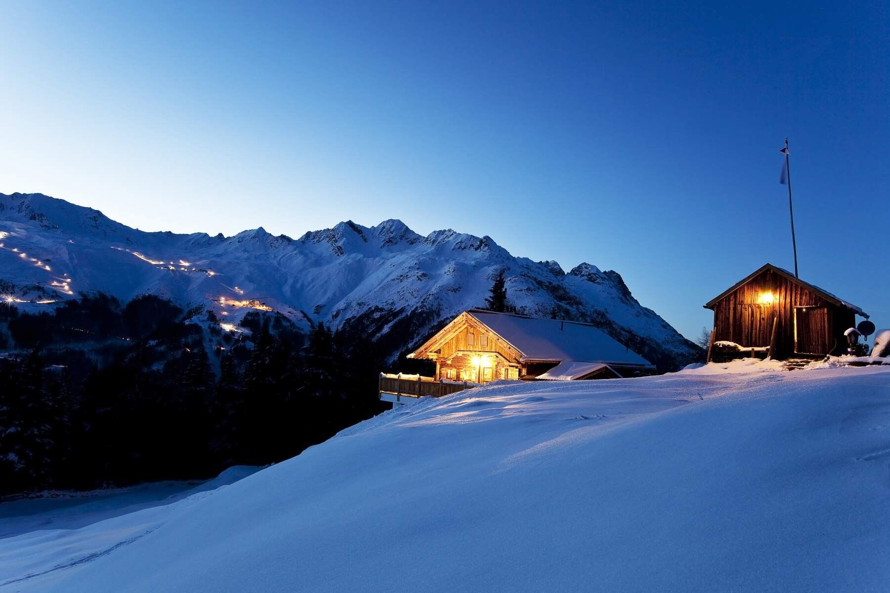
Place:Sölden
:Alpine pasture / hut / mountain restaurant
PARKING LOT BARRIER --> Stallwiesalm --> PARKING LOT BARRIER
Anyone doing the tour in the evening for the hut evening should definitely have a headlamp with them. --> no floodlight
Please note the current snow and avalanche report for the coming days:
https://www.oetztal.com/de/winter.html & https://avalanche.report/albina-web/bulletin/bulletin/bulletin/bulletin/bulletin/bulletin/latest?lang=de
Avalanche danger scale
1 (LOW)
An avalanche release is only possible under a high additional load on very few, extreme steep slopes. Spontaneous avalanches (so-called slides) are not expected. Generally safe conditions.
2 (MODERATE)
An avalanche release is likely under a high additional load especially on specified steep slopes. Larger avalanches are not expected. The snow cover is generally well consolidated except for some steep slopes. Careful route selection on specified steep slopes and slope exposures.
3 (CONSIDERABLE)
An avalanche release is likely already with little additional load especially on specified steep slopes. Occasionally, some medium avalanches and occasionally also large avalanches are possible spontaneously. The snow cover on many steep slopes is only moderately to weakly consolidated. Experience in avalanche assessment is necessary. Avoid specified steep slopes and slope exposures as much as possible.
4 (HIGH)
An avalanche release is possible even with little additional load especially on specified steep slopes. Many medium and multiple large avalanches may occur occasionally. On many steep slopes, the snow cover is only weakly consolidated. Limit route choice to moderately steep terrain and pay attention to avalanche runout zones. A lot of experience in avalanche assessment is necessary.
5 (VERY HIGH)
Numerous large avalanches, also in moderately steep terrain, are expected spontaneously. At this warning level, safe operation in ski areas is no longer possible. The snow cover is generally weakly consolidated and unstable. It is recommended to refrain from tours.
Recommended ski touring equipment
The "standard ski touring equipment" consists of touring skis with touring bindings, telescopic poles, climbing skins, crampons, a digital avalanche transceiver, avalanche shovel, avalanche probe, first aid kit, and a mobile phone. A "complete glacier equipment" consists of a harness, two prusik loops of different lengths or ascenders, two HMS carabiners, an ice axe, crampons, and a rope. A backpack with appropriate contents should be carried, including change of clothes, sun protection, cold protection, food, and sufficient drinks! For hut overnight stays do not forget hygiene articles and a hut sleeping bag!
For tours in the evening, you should have a headlamp with you --> no floodlight
DIFFICULTY RATING
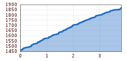
You can start the leisurely route to Stallwiesalm directly at the parking lot below the barrier. From there, a wide, groomed forest road leads you to Stallwiesalm. With sufficient snow, signposted shortcuts through the forest can sometimes also be used.
For the ascent from the parking lot barrier, you need about 2 hours on a leisurely tour.
The descent is not particularly difficult, as the same route is used as for the ascent.
Travel comfortably and safely by train to the ÖTZTAL station. The final stop or exit point is the ÖTZTAL station. Afterwards, you travel conveniently and quickly by public transport or local taxi companies throughout the valley to your desired destination.
The current bus schedule is available at: https://fahrplan.vvt.at
The following parking options are available in Sölden:
The parking lots are paid.


