Wechnerscharte

Route length: 5.8 km
Duration: 3:30 h

Wechnerscharte

Tour information

  • Length: 5.8 km
  • Duration: 3:30 h
  • Elevation uphill:880 hm
  • Elevation downhill:0 hm
Highest point2,758 m

Starting point

Parkplatz Speicher Längental (gebührenfrei)

Finishing point

Wechnerscharte

Best time of year

  • January
  • February
  • March
  • April
  • May
  • June
  • July
  • August
  • September
  • October
  • November
  • December
Source: Innsbruck Tourismus

Description

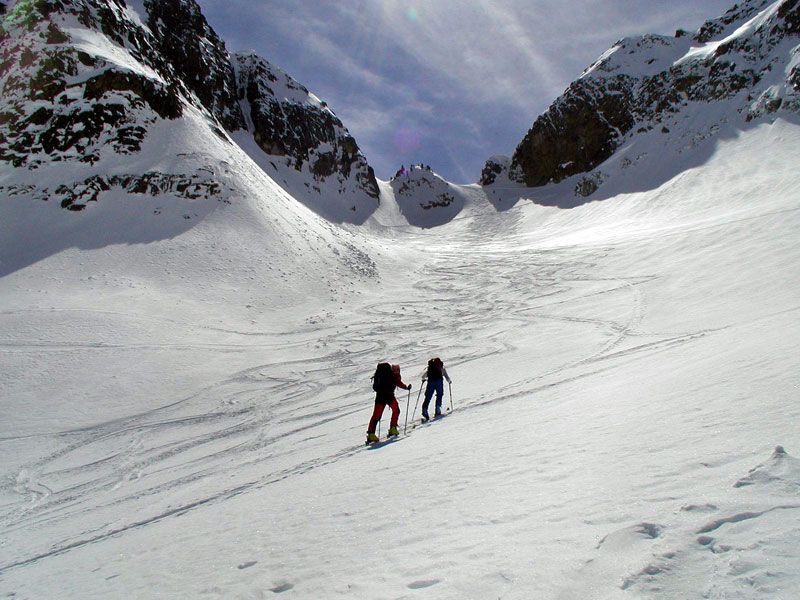
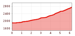
This popular ski tour in Kühtai starts at the Längental reservoir and runs steadily uphill - mostly along a small stream - through the impressive Mittertal valley. Surrounded by striking peaks, the route leads through a tranquil winter landscape, which often attracts visitors with the best powder snow until well into spring, especially in the upper section. The final ascent over steep slopes up to the deeply incised saddle requires fitness and confident ski touring skills. A rewarding tour for all those who appreciate views and a sporting challenge.

More tours in the surrounding area

  • Breiteggspitze

    Difficulty:easy
    Length:3.4 kmDuration:2:00 hElevation uphill:700 m
  • Patscherkofel Schutzhaus

    Difficulty:medium
    Length:13.3 kmDuration:2:30 hElevation uphill:1,000 m
  • Eichenhof

    Difficulty:medium
    Length:4.7 kmDuration:2:50 hElevation uphill:898 m
  • Hoadl-Haus

    Difficulty:easy
    Length:7.6 kmDuration:2:25 hElevation uphill:778 m
  • Mutterer Alm

    Difficulty:medium
    Length:3.1 kmDuration:2:00 hElevation uphill:581 m
  • Bichalm

    Difficulty:easy
    Length:2.4 kmDuration:1:30 hElevation uphill:450 m
  • Seefelder Joch

    Difficulty:medium
    Length:5.8 kmDuration:2:30 hElevation uphill:866 m
Newsletter

The mountain is calling? So does our newsletter!

In our monthly newsletter we reveal the best holiday tips for Tyrol.