Wetterkreuzkogel

Route length: 4.5 km
Duration: 3:00 h

Wetterkreuzkogel

Tour information

  • Length: 4.5 km
  • Duration: 3:00 h
  • Elevation uphill:850 hm
  • Elevation downhill:0 hm
Highest point2,592 m

Best time of year

  • January
  • February
  • March
  • April
  • May
  • June
  • July
  • August
  • September
  • October
  • November
  • December
Source: Innsbruck Tourismus

Description

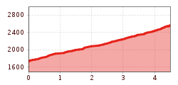
This tour starts just a few kilometres away from Kühtai and heads across the Obere Issalm, through the Wörgetal valley and the upper reaches of the peak's plateau to the summit cross. Descent is via the same path. How to get there: Drive from Kühtai towards Ötztal. After about 3km, you'll find a parking area at the bridge.

More tours in the surrounding area

  • Breiteggspitze

    Difficulty:easy
    Length:3.4 kmDuration:2:00 hElevation uphill:700 m
  • Seefelder Joch

    Difficulty:medium
    Length:5.8 kmDuration:2:30 hElevation uphill:866 m
  • Eichenhof

    Difficulty:medium
    Length:4.7 kmDuration:2:50 hElevation uphill:898 m
  • Hoadl-Haus

    Difficulty:easy
    Length:7.6 kmDuration:2:25 hElevation uphill:778 m
  • Mutterer Alm

    Difficulty:medium
    Length:3.1 kmDuration:2:00 hElevation uphill:581 m
  • Bichalm

    Difficulty:easy
    Length:2.4 kmDuration:1:30 hElevation uphill:450 m
  • Patscherkofel Schutzhaus

    Difficulty:medium
    Length:13.3 kmDuration:2:30 hElevation uphill:1,000 m
Newsletter

The mountain is calling? So does our newsletter!

In our monthly newsletter we reveal the best holiday tips for Tyrol.