

Opening hours:closed
Difficulty:medium
Length:53.0 kmDuration:15:30 hElevation uphill:1,060 m
Trail Nr.: 35
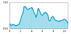
Start at the information office in Walchsee. From there, head to the parish church and continue along the hiking trail westward across the Ramsbach Bridge. Pass behind the tennis courts until you reach Seestraße, then continue left until you reach the next farm (Schusterbauer). Then turn right immediately and follow the path to the Amberglift. Here, turn left and follow the main road through the Durchholzen district to the former Plangger cheese dairy; from there, turn right via Miesberg and Rettenschöss to Schwaigs. Walk along the Moarhof golf course and the Schwemm (North Tyrol’s largest moorland) back to the village center.


