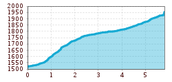
Open interactive mapOpen this POI on the interactive mapElevation profileWinterwanderung ins Rojental.gpx
Bergdoktor-Winter Hiking TrailDifficulty:easyLength:2.1 kmDuration:0:45 hElevation uphill:40 mGo to winter hikeGo to winter hike: Bergdoktor-Winter Hiking Trail
Winter- und Schneeschuhwandern (c) Mirja Geh (26).jpg © Mirja Geh At the foot of Fleischbank and TotenkirchlDifficulty:easyLength:9.3 kmDuration:3:00 hElevation uphill:250 mGo to winter hikeGo to winter hike: At the foot of Fleischbank and Totenkirchl
Wildschönau Thierbach Church Winter.jpg © Wildschönau Tourismus FG Dabernig Hannes Around the Thierbach HilltopDifficulty:mediumLength:5.5 kmDuration:2:00 hElevation uphill:162 mGo to winter hikeGo to winter hike: Around the Thierbach Hilltop
Winter hiking Fieberbrunn - Zillstatt - StreubödenOpening hours:closedDifficulty:mediumLength:13.0 kmDuration:4:30 hElevation uphill:550 mGo to winter hikeGo to winter hike: Winter hiking Fieberbrunn - Zillstatt - Streuböden
Wildschönau Niederau Foisching © Hannes Dabernig Niederau - Foisching HutDifficulty:easyLength:6.5 kmDuration:2:15 hElevation uphill:253 mGo to winter hikeGo to winter hike: Niederau - Foisching Hut
Wildschönau Niederau Markbachjoch Kapelle Winter.jpg © Wildschönau Tourismus Winterwanderung Markbachjoch - NiederauDifficulty:mediumLength:10.5 kmDuration:4:00 hElevation uphill:56 mGo to winter hikeGo to winter hike: Winterwanderung Markbachjoch - Niederau
Ehenbichler Alm © Robert Eder, Naturparkregion Reutte Winter walk to the Ehenbichler Alm hutDifficulty:difficultLength:6.5 kmDuration:4:00 hElevation uphill:640 mGo to winter hikeGo to winter hike: Winter walk to the Ehenbichler Alm hut
Frauenseestube aerial view © Robert Eder Winter Hike to Lake Frauensee from LechaschauDifficulty:easyLength:7.2 kmDuration:2:30 hElevation uphill:122 mGo to winter hikeGo to winter hike: Winter Hike to Lake Frauensee from Lechaschau
Vilser Alm im Winter © Robert Eder Winter walk to the Vilser Alm hutDifficulty:mediumLength:6.6 kmDuration:2:30 hElevation uphill:348 mGo to winter hikeGo to winter hike: Winter walk to the Vilser Alm hut
Winterwandern in der Naturparkregion Reutte © Peter Neusser Hike to the Ehrenberg castle ruinsDifficulty:mediumLength:5.1 kmDuration:1:45 hElevation uphill:237 mGo to winter hikeGo to winter hike: Hike to the Ehrenberg castle ruins
Schneeschuhwanderung © Bernd Ritschel Circular hiking trail Horlachtal - NiederthaiOpening hours:closedDifficulty:easyLength:6.9 kmDuration:2:00 hElevation uphill:233 mGo to winter hikeGo to winter hike: Circular hiking trail Horlachtal - Niederthai
Wurzbergalm © Ötztal Winter walk to the Wurzbergalm hut in UmhausenOpening hours:closedDifficulty:easyLength:2.4 kmDuration:1:00 hElevation uphill:199 mGo to winter hikeGo to winter hike: Winter walk to the Wurzbergalm hut in Umhausen
winterwander-kappl-see-2019 (83).jpg © TVB Paznaun-Ischgl 01 "Weiße Weiten” (White Vistas) winter long-distance trailDifficulty:mediumLength:52.7 kmDuration:14:00 hElevation uphill:1,579 mGo to winter hikeGo to winter hike: 01 "Weiße Weiten” (White Vistas) winter long-distance trail
Wildschönau Niederau Auenweg Sommer © Wildschönau Tourismus Auenweg NiederauDifficulty:easyLength:1.0 kmDuration:0:30 hElevation uphill:31 mGo to winter hikeGo to winter hike: Auenweg Niederau
Schönwieshütte © Ötztal Tourismus Information Gurgl Winter hiking trail Steinmannbahn mountain station - Schönwieshütte - No. 8Opening hours:closedDifficulty:easyLength:1.2 kmDuration:0:30 hElevation uphill:33 mGo to winter hikeGo to winter hike: Winter hiking trail Steinmannbahn mountain station - Schönwieshütte - No. 8
Weitwandern Etappe 3 Winterlandschaft (1).jpg © Region Seefeld, Johannes Geyer Complete Route for the Tyrol’s 1. Winter Multi-day HikeOpening hours:closedDifficulty:mediumLength:53.0 kmDuration:15:30 hElevation uphill:1,060 mGo to winter hikeGo to winter hike: Complete Route for the Tyrol’s 1. Winter Multi-day Hike
Winter walk Schwarzer See, NaudersDifficulty:easyLength:10.5 kmDuration:3:30 hElevation uphill:255 mGo to winter hikeGo to winter hike: Winter walk Schwarzer See, Nauders
Evening winter hike Kleinmutzkopf, NaudersDifficulty:easyLength:6.0 kmDuration:2:00 hElevation uphill:70 mGo to winter hikeGo to winter hike: Evening winter hike Kleinmutzkopf, Nauders
winterwanderweg rotes wandl - nr. 431_img_56893137 © Ötztal Tourismus Büro Oetz Winter hiking trail Rotes Wandl - No. 431Opening hours:openDifficulty:easyLength:1.5 kmDuration:0:45 hElevation uphill:52 mGo to winter hikeGo to winter hike: Winter hiking trail Rotes Wandl - No. 431
Winterwandern Winter Schnee © Oliver Soulas / Tirol Werbung Premium winter hiking trail - panoramic trailOpening hours:closedDifficulty:easyLength:4.2 kmDuration:1:30 hElevation uphill:80 mGo to winter hikeGo to winter hike: Premium winter hiking trail - panoramic trail
Ellmau_Biedringer Platte_Winterwanderung_Wilder Kaiser © TVB Wilder Kaiser/Maria Luise Handl Winter walking Biedringer PlatteOpening hours:closedLength:12.7 kmDuration:5:30 hElevation uphill:470 mGo to winter hikeGo to winter hike: Winter walking Biedringer Platte
Flusserlebnis Grossache © www.MirjaGeh.com Scenic River Trail GroßacheDifficulty:easyLength:14.3 kmDuration:3:30 hElevation uphill:20 mGo to winter hikeGo to winter hike: Scenic River Trail Großache
Filzenkogel winter walk in MayrhofenDifficulty:mediumLength:3.6 kmDuration:1:30 hElevation uphill:250 mGo to winter hikeGo to winter hike: Filzenkogel winter walk in Mayrhofen
winterwandern17-kartitsch-c-tvb-osttirol-bergimbild.jpg © BergimBild HollbruckertalwegOpening hours:closedDifficulty:mediumLength:3.1 kmDuration:1:30 hElevation uphill:80 mGo to winter hikeGo to winter hike: Hollbruckertalweg
Winter Walking on the Sunny Mieming PlateauDifficulty:easyLength:9.0 kmDuration:2:30 hElevation uphill:140 mGo to winter hikeGo to winter hike: Winter Walking on the Sunny Mieming Plateau
Give feedback for a chance to win a special holiday experience!Click here for the surveyClick here for the survey

 Mirja Geh (26).jpg")


.jpg")


.jpg")
.jpg")
.jpg")


