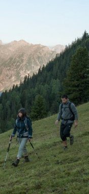
Mountain bike rides in Ischgl
Map

Show
on mapBike Trail Tirol Stage 29: Landeck - Ischgl
on mapBike Trail Tirol Stage 29: Landeck - Ischgl
Bike Trail Tirol
Length: 33km
Elevation uphill: 1,250m
Riding time: 5h
Difficulty rating: difficult

Show
on mapBike Trail Tirol Stage 30: Ischgl - St. Anton
on mapBike Trail Tirol Stage 30: Ischgl - St. Anton
Bike Trail Tirol
Length: 42km
Elevation uphill: 1,290m
Riding time: 6h
Difficulty rating: difficult

Show
on mapFlimjoch Trail
on mapFlimjoch Trail
Singletrails
Starting point: Top of Flimjochbahn cable car
Length: 3km
Riding time: 0 h 12 min
Difficulty rating: Singletrack intermediate

Show
on mapHeidelberger Hütte
on mapHeidelberger Hütte
Mountain biking
Starting point: Bottom of Silvrettabahn cable car, Ischgl
Length: 27km
Elevation uphill: 940m
Riding time: 3 h 30 min
Difficulty rating: medium

Show
on mapIdalp - Flimjoch
on mapIdalp - Flimjoch
Mountain biking
Starting point: Bottom station of Silvrettabahn cable car in Ischgl
Length: 24km
Elevation uphill: 1,397m
Difficulty rating: difficult

Show
on mapSamnaun Mountains Loop
on mapSamnaun Mountains Loop
Mountain biking
Starting point: Serfaus
Length: 142km
Elevation uphill: 4,140m
Duration: 4 day(s)
Difficulty rating: difficult
Ischgl: mountain bike rides in the region

Kappl
Located just a few kilometres from the well-known winter resort of Ischgl,…

Kappl
Starting from the village of Kappl in the Paznauntal Valley, at the foot of…

Galtür
This easy ride leads uphill along tarmac and gravel trails from Galtür at…
Quality-approved accommodation for cyclists in Ischgl

Ischgl
Our hotel is named after 'Arnika', a mountain plant with excellent healing…

Ischgl
Our hotel is situated at the beginning of the village, very romantic,…

Ischgl
The Fliana is a 4- star -Superior - Hotel in a sunny and quiet location on…