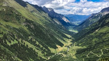
This walk of intermediate difficulty leads through meadows and pastures at the end of the Navistal Valley. It includes blooming alpine roses and narrow winding paths with some fantastic views of the Tux Alps all the way across to the Stubai Alps. En route, hikers pass several huts serving food: the Peeralm, Klammalm, Poltenalm, Stöcklalm and Naviser Hütte. In Navis it is well worth visiting the Haus Hörtnagl, which sells homemade schnapps as well as other regional products. Keep your eyes open as you walk through the village to spot the intricate frescoes by local artist Franz de Paula Penz.


Starting point
Schranzberg car park
Finishing point
Schranzberg car park
Mountain chain
Tux Alps
Length
12.7 km
Total hiking time
4 h 30 min
Features
- Wheelchair-accessible Hiking Route
- Circular hike
Difficulty rating
intermediate (red mountain trails)
Altitude
1,962m 1,399m
Elevation uphill 585m
Vertical metres downhill 585m
Fitness level
Best time of year
Jan
Feb
Mar
Apr
May
Jun
Jul
Aug
Sep
Oct
Nov
Dec
* These are approximate values and recommendations. Please take your personal fitness level, technical ability and the current weather conditions into account. Tirol Werbung cannot guarantee that the information provided is correct and accepts no liability.
Parking
Schranzberg car park
Places serving food & drink
- Peeralm
- Klammalm
- Poltnalm
- Stöcklalm
- Naviser Hütte
Downloads
Trail description
The starting point of this hike is the Schranzberg car park at the end of the valley in Navis. From there, the route initially climbs gently along the Naviser Au or, alternatively, to the right above it on a forest path to the bridge over the Klammbach stream. Following the signs, the route leads across the stream and then turns right onto a trail leading to the Peeralm hut at around 1,600 metres above sea level. From here, the trail climbs gently along a beautiful forest path. About a kilometre after crossing the stream again, the alpine path makes a sharp right turn; there, turn left onto the trail that leads directly to the Klammalm, the highest point of this hike. This is also the half-way point. From the end of the valley, hike back on the opposite side of the valley, past the Poltnalm, Stöcklalm and the Naviser Hütte huts to the starting point.
Information on place

Hiking trails in this region
Steinach
Mighty mountains, lush meadows and cosy huts are the reward for almost 60…

Navis
The remote Navis Valley in the Tux Alps is home to many mountains which can…

Navis
With around 1,200 vertical metres of ascent, the climb up to the Kreuzjöchl…
