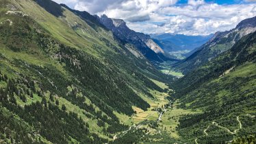
With around 1,200 vertical metres of ascent, the climb up to the Kreuzjöchl (2,536 metres) is one of the most challenging in the Tux Alps but rewards hikers with fine views. En route you pass three huts serving food and drink. The walk begins at the Schranzberg car park (1,420 metres) near Navis.

Summit Hike
Starting point
Schranzberg car park near Navis
Hike to
Naviser Kreuzjöchl
Finishing point
Schranzberg car park near Navis
Mountain chain
Tux Alps
Length
12.5 km
Total hiking time
7 h 30 min
Features
- Wheelchair-accessible Hiking Route
- Circular hike
Difficulty rating
intermediate (red mountain trails)
Altitude
2,536m 1,393m
Elevation uphill 1,173m
Vertical metres downhill 1,173m
Fitness level
Technique
Best time of year
Jan
Feb
Mar
Apr
May
Jun
Jul
Aug
Sep
Oct
Nov
Dec
* These are approximate values and recommendations. Please take your personal fitness level, technical ability and the current weather conditions into account. Tirol Werbung cannot guarantee that the information provided is correct and accepts no liability.
Public transport
- Accessible using public transport
Bus route 8365, get off at stop Navis Dorf
Parking
Schranzberg car park near Navis
Places serving food & drink
- Naviser Hütte (January until March, May until December)
- Stöcklalm (mid-May until mid-October)
- Polten Alm (May until October)
Downloads
Trail description
From the Schranzenberg car park near Navis there is a wide path heading up towards the Naviser Hütte (1,785 metres) but hikers can instead take the narrower trail which is shorter and steeper. Eventually you will reach the Naviser Hütte, the first of several huts en route serving food and drink. From there it is another 20 minutes or so to the Stöcklalm at (1,882 metres) where hearty Tirolean food is also available. From this second hut, the trail winds its way up to a grassy ridge and then on to the top of the Naviser Kreuzjöchl (2,536 metres) marked by a mighty crucifix. This mountain is a popular destination in both summer (hiking) and winter (ski touring), not least thanks to its fine views of the surrounding peaks including the Mieslkopf, Pfoner Kreuzjöchl, Grünberger and Sonnenspitze.
The descent can be completed along the same route as the ascent. Alternatively, if you wish to turn this into a circular hike then you can walk back for a bit along the way you came, then turn off right and hike across the nothern flank of the Kreuzjöchls until you meet the trail towards the Polten Alm (1,880 metres), another good place to stop for a meal. From there it is simply a case of heading back to the Naviser Hütte and then down to the car park.
Information on place

Hiking trails in this region
Steinach
Mighty mountains, lush meadows and cosy huts are the reward for almost 60…

Gschnitz
Located at 2,369 metres above sea level, between the Gschnitztal Valley and…

Scharnitz
From the rushing Isar river to the Adriatic Sea, from the Tirolean…
