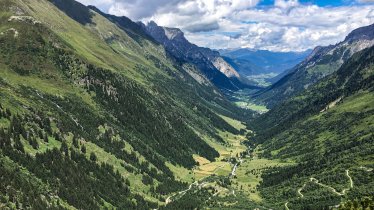
From the rushing Isar river to the Adriatic Sea, from the Tirolean chocolate-box village of Scharnitz to the Gulf of Venice, the Via Venezia Alpina Trail comprises 470 kilometres and 21,800 vertical metres from Bavaria in Germany through the Austrian Tirol to Italy. It takes about three weeks to complete the entire route. It reveals the beauty of the mountains, unfolds the glaciated expanses of the Alps, traverses deep forests and ends at the beautiful upper reaches of the Adriatic Sea in Venice, nicknamed 'La Serenissima'. On its eight segments through Tirol, the Via Venezia Alpina offers long-distance hiking and Alpine beauty at its best, culminating in the pinnacle of the mighty Birkkarspitze mountain, the Hinterautal Valley and the “7 TuXer summits”. Long-distance hiking on the Via Venezia Alpina should not be underestimated. It requires mountaineering skills, stamina and sure footing. All users should be familiar with basic alpine techniques, precautions and orienteering skills. Detours are recommended in the event of inclement weather. Hiking long distance, from the Austria-Germany-Austria border through Karwendel Mountains and across Italy’s provinces of Alto Adige and Belluno to Venice is undeniably a remarkable physical achievement. An experience that will creates memories for a lifetime!


Long-Distance Hiking Trail
Starting point
Scharnitz
Finishing point
Venice, Italy
Mountain chain
Tux Alps
Zillertal Alps
Karwendel Mountains
Length
470.5 km
Duration
22 day(s)
Features
- Wheelchair-accessible Hiking Route
- Circular hike
Difficulty rating
difficult (black trails)
Altitude
3,150m 10m
Elevation uphill 21,800m
Vertical metres downhill 22,800m
Fitness level
Technique
Best time of year
Jan
Feb
Mar
Apr
May
Jun
Jul
Aug
Sep
Oct
Nov
Dec
* These are approximate values and recommendations. Please take your personal fitness level, technical ability and the current weather conditions into account. Tirol Werbung cannot guarantee that the information provided is correct and accepts no liability.
Public transport
- Accessible using public transport
Downloads
Trail description
Day 1: Scharnitz – Karwendelhaus Lodge
Uphill: 890 vertical metres | walking time: 5 hours | distance: 17.2 kilometres
Right from the start, this hike treats walkers to awesome beauty and natural splendour. From Scharnitz at the start of the Karwendel Mountains, this segment takes you up to Karwendelhaus Lodge (1,765m) across scenic the Karwendeltal Valley. From the trailhead at the railway station in Scharnitz, follow signage to Karwendelhaus and walk past Birzlkapelle Chapel to Larchetalm hut (1,171m). The trail has steep switchbacks that weave through the heart of Karwendel Nature Park and bring you to the final destination of this day, the Karwendelhaus lodge.
Day 2: Karwendelhaus Lodge – Hallerangerhaus Lodge
Uphill: 1,490 vertical metres | walking time: 8 hours | distance: 14.6 kilometres
From the Karwendelhaus lodge, this difficult and long section is challenging but very rewarding. Follow "AV-Steig" number 225 southward up to the high ridgeline, crossing Schlauchkar cirque and Schlauchkar saddle (2,639m). Experienced hikers can summit the Birkkarspitze peak, from where there are uninterrupted panoramic views. A knee-jarring descent takes you into the pretty Hinterautal Valley and on to the Kastenalm hut (1,220m). The route continues along trail number 224 to Lafatscher Niederleger and the Kohleralm hut, before rclimbing once again up to the Hallerangerhaus lodge (1,768m). You can also spend the night at the nearby Hallerangeralm hut (1,774m).
Day 3: Hallerangerhaus Lodge – Absam – Hall
Uphill: 400 vertical metres | walking time: 5.5 hours | distance: 14.5 kilometres
Climbing steeply, the trail works its way from the Hallerangerhaus lodge up to the 2,081-metre-high Lafatscher Joch. From the ridge, walk down across fields of dwarf pines on a gravel trail until you reach beautiful Issanger, carpeted in a mosaic of brilliant wildflowers. The former Abbey of St. Magdalene provides a perfect place for hikers to stop and rest. Once replete and replenished, continue the descent through Halltal Valley, with the Fluchtsteig path providing a welcome escape from the paved mountain road. The Salzbergstraße road then winds all the way down to the historic small town of Hall in Tirol (574m), which has a rich minting heritage and is a charming place full of cobbled streets and sights.
Day 4: Hall – Glungezer Hut
Uphill: 2,040 vertical metres | walking time: 5 hours | distance: 18.7 kilometres
This segment takes you from Hall in Tirol across the southern foothills of the Alps to the Tux Alps. Your feet can still relax for a little while as you catch the shuttle bus from Hall to Tulfes. Should you decide to walk this section, take the path across the old wooden bridge that crosses the Inn river at Gasthof Badl Inn and ascend the country road to the left until you reach the base of the Glungezerbahn cable car in Tulfes. You can ride the chairlift up to Tulfein (2,060m). Alternatively, if you prefer to walk, follow the mountain road up to Windegg and the Tulfeinalm hut (2,035m). Continue climbing along the “Kurt-Recheis-Weg” trail (number 333) until you reach the Tulfeinjöchl ridge (2,278m). Here you will find the small cable car used to transports supplies to the Glungezer Hütte hut. If you wish, you can have your luggage carried up. Unencumbered by your daypack, follow the Glungezer Panorama Trail to the final destination, which is the Glungezer Hütte hut (2,610m).
Day 5: Glungezer Hut – Lizumer Hut
Uphill: 920 vertical metres | walking time: 9 hours | distance: 15.2 kilometres
From the Glungezer Hütte hut, trail AV 335 climbs along the beautiful, rugged “Seven TuXer Summits” ridge to the Lizumer Hütte. Steep, rough, and strenuous, this trek requires stamina and sure footing; some rugged sections have a fixed anchoring system of cables (which in times of snow or adverse weather conditions are best left to those with mountaineering experience; detours are available). This is perfect terrain for peak baggers: heading southward you will first reach the 2,677-metre-high summit of the Glungezer, followed by the ridgetop peaks of Gamslahner (2,681m), Kreuzspitze (2,746m), Rosenjoch (2,796m), Grünbergspitze (2,790m), Grafmartspitze (2,720m) and Naviser Jöchl (2,479m). If you have the time and energy for yet another peak, you can conquer the summit of the 2,619-metre-high Naviser Sonnenspitze before reaching Mölsjoch ridge (2,334m). From the ridge, continue past the 2,440-metre-high summit of the Nördliche Schoberspitze and the 2,359-metre-high Klammjoch ridge all the way to the Lizumer Hütte hut (2,019m).
Less demanding detours can be made along the Gwannsteig Trail, across the Halsmarter-Voldertal Valley or through the Wattental Valley.
Day 6: Lizumer Hut – Tuxerjochhaus Lodge
Uphill: 1,300 vertical metres | walking time: 7 hours | distance: 12 kilometres
The ultimate rewards come to those who have enough strength to tackle this demanding yet scenic stage. From the Lizumer Hütte hut, the trail rounds below the Sonnenspitze mountain to the Geiermulde and Pluderlingsattel saddle (Geierjoch), which offers sweeping views of nearby mountains, glaciers and valleys. Peak baggers can nab the summit of the 2,857-metre-high Hoher Geier Peak. From the Pluderlingsattel saddle, trail number 323 steeply winds its way down to the Junssee lake and the pristine “Tote Böden”, an area of awesome natural beauty. The trail resumes its climb up Geschützspitzsattel saddle and descends steep grassy slopes on its way down into the Weitental Valley. The final push to the Tuxerjoch ridge is a steep section that will take you up, up, up to the Tuxerjochhaus lodge. The rewards for the efforts of the day are great: the lodge offers horizon-spanning views of jagged ridges and colossal summits such as the Olperer, the Gefrorene Wand and the Riffler.
Day 7: Tuxerjochhaus Lodge – Friesenbergscharte Notch – Friesenberghaus Lodge
Uphill: 890 vertical metres | walking time: 6 hours | distance: 7.7 kilometres
This demanding segment takes you to the heart of the Zillertal Alps High Mountain Nature Park and presents hikers with a number of technical challenges. From the Tuxerjochhaus lodge, walk to the Spannagelhaus lodge and across the ski resort on the Hintertux Glacier. After crossing the bridge over the rushing glacier stream, the trail works its way uphill through alpine terrain full of boulders and snowfields all the way up to the Friesenbergscharte ridge. This is the second-highest point on the entire Via Venezia Alpina long-distance hiking trail at 2,904 metres above sea level. The final section is a scramble across a steep talus and scree slope, which is a bit of a route-finding endeavour (keeps your eyes out for the waymarking posts). The passage to the Zillertal Alps High Mountain Nature Park is very narrow. At the same time, breathtaking views open up around you. The descent to the Friesenberghaus lodge, which is situated beneath the lake of the same name, has assisted a fixed anchoring system of cables. If you still have the energy, you can bag the summit of the Petersköpfl mountain when you arrive at the lodge.
Day 8: Friesenberghaus Lodge – Schlegeis Reservoir – Pfitscherjoch Col
Uphill: 740 vertical metres | walking time: 6.5 hours | distance: 12.6 kilometres
From the Friesenberghaus lodge in the Zillertal Alps, the route follows the “Berlin High Trail” to the spectacular Olperer Hütte hut at an elevation of 2,389 metres. The hut affords stunning views of Schlegeis reservoir and of sparkling and glistening glaciers. The trail continues westwards beneath the Gefrorene Wand and Riffler until you reach a rock that marks the border between Austria and Italy. From there, it’s a short walk to the Pfitscher Joch-Haus lodge (2,275m). Standing on Italian ground in South Tyrol/Alto Adige, this is where the Tirol section of the Via Venezia Alpina long-distance hiking trail ends.
Day 9 - 22: Pfitscherjoch Col – Venice
For details on the Italian section of the Via Venezia Alpina, stages 9 to 22, please click here (German only).
You will find trail descriptions of all stages at www.alpenvereinaktiv.com (German only).
More information on the “7 TuXer Summits” Tour is available at www.7tuxer.at (German only).
Information on place


Hiking trails in this region
Steinach
Mighty mountains, lush meadows and cosy huts are the reward for almost 60…

Gschnitz
Located at 2,369 metres above sea level, between the Gschnitztal Valley and…

Steinach
The Blaser is 2,241-metre-high-mountain whose name means "blower", probably…
