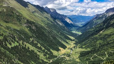
The Blaser is 2,241-metre-high-mountain whose name means "blower", probably in reference to the strong wind which almost always blows on its summit. This hike starts in the village of Trins and leads through flower-filled meadows. In June, when the pastures are in full bloom, the Blaser is one of the most flower-rich mountains in Tirol. The Blaser-Hütte hut is a good place to stop for a drink and a snack. It offers fine views of the Serles mountain, After a short final uphill section to the summit, it is time to descend via the Maria Waldrast place of pilgrimage.

Summit Hike
Starting point
Trins, car park in Leiten
Hike to
Summit of Blaser mountain
Finishing point
Trins, car park in Leiten
Mountain chain
Stubai Alps
Length
15 km
Total hiking time
7 h 30 min
Features
- Wheelchair-accessible Hiking Route
- Circular hike
Difficulty rating
intermediate (red mountain trails)
Altitude
2,241m 986m
Elevation uphill 1,031m
Vertical metres downhill 1,331m
Fitness level
Technique
Best time of year
Jan
Feb
Mar
Apr
May
Jun
Jul
Aug
Sep
Oct
Nov
Dec
* These are approximate values and recommendations. Please take your personal fitness level, technical ability and the current weather conditions into account. Tirol Werbung cannot guarantee that the information provided is correct and accepts no liability.
Public transport
- Accessible using public transport
Parking
Trins, car park in Leiten
Places serving food & drink
- Blaser Hütte (open from June until September)
Downloads
Trail description
The hike begins in the village of Trins in the Gschnitzta Valley, at a small car park in the settlement of Leiten. From there, take the forest road in a westerly direction through thick forest and then uphill in a north-easterly direction. At around 1600 metres above sea level there is a trail which begins, winding its way up through a series of meadows to the Blaser-Hütte hut. From the Blaser-Hütte hut it is just a short walk to the top of the Blaser mountain. From the summit you can enjoy fine views of the Serles mountain to the north-west and the Maria Waldrast place of pilgrimage to the north. The descent leads through the Langes Tal valley to Maria Waldrast then down to Matrei. From here you can take public transport back to the starting point. There is a regular train service from Matrei am Brenner to Steinach am Brenner, where you can change to a bus into the Gschnitztal Valley. The bus ride takes about 15 minutes to Trins. Get off at the "Wienerhof" stop. It is then just a short walk back to the car park.
Information on place

Hiking trails in this region
Steinach
Mighty mountains, lush meadows and cosy huts are the reward for almost 60…

Gschnitz
Located at 2,369 metres above sea level, between the Gschnitztal Valley and…

Scharnitz
From the rushing Isar river to the Adriatic Sea, from the Tirolean…
