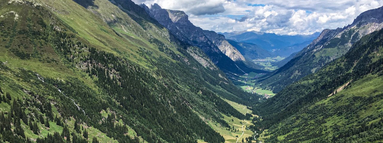
Mighty mountains, lush meadows and cosy huts are the reward for almost 60 kilometres of walking and around 4,500 vertical metres. The Gschnitztal Hut Hike takes walkers all the way around the Gschnitztal Valley, a side valley of the Wipptal Valley, and demands good fitness and safe footing. It takes six days to complete and starts in Steinach am Brenner. From there it leads over the Nösslachjoch rige, through the impressive Tribulaun Massif, along sections of the Stubaier High Trail up onto the Padasterjoch ridge and to the foot of the mighty Blaser mountain. Hikers stay in a hut each night. From each hut there is the option to descend down into the valley.
Long-Distance Hiking Trail
Starting point
Top of cable car, Nösslachjoch
Hike to
Tribulaunhütte, Bremer Hütte, Innsbrucker Hütte, Padasterjochhaus, Blaserhütte
Finishing point
Bottom of Bergeralmbahn cable car
Mountain chain
Stubai Alps
Length
65.4 km
Duration
7 day(s)
Features
- Wheelchair-accessible Hiking Route
- Circular hike
Difficulty rating
difficult (black trails)
Altitude
2,713m 1,063m
Elevation uphill 5,099m
Vertical metres downhill 5,621m
Fitness level
Technique
Best time of year
Jan
Feb
Mar
Apr
May
Jun
Jul
Aug
Sep
Oct
Nov
Dec
* These are approximate values and recommendations. Please take your personal fitness level, technical ability and the current weather conditions into account. Tirol Werbung cannot guarantee that the information provided is correct and accepts no liability.
Parking
Car park (free) at bottom of Bergeralmbahn cable car
Places serving food & drink
- Stage 1: Trunaalm (mid-June until mid-September), Tribulaunhütte (June until late September)
- Stage 2: Bremer Hütte (late June until late September)
- Stage 3: Innsbrucker Hütte (late June until early October), Karalm (late May until mid-October), Pinnisalm (open all year when the Elferbahnen lifts are running; for information visit www.stubai.at/skigebiete/elferbahnen/skigebiet/oeffnungszeiten/)
- Stage 4: Padasterjochhaus (June until late September)
- Stage 5: Blaserhütte (early June until mid-October)
- Stage 6: Various locations in Steinach am Brenner
Downloads
Trail description
Stage 1: Steinach am Brenner – Tribulaunhütte
Vertical ascent/descent: 779/797 metres, walking time: 6 hours, distance: 12.8 kilometres, highest point: 2,538 metres, difficulty: difficult
This hike begins in Steinach am Brenner with a ride up on the Bergeralmbahn cable car before hikers change onto the Bergbahn Hoher Turm lift to the Nösslachjoch. From the top of the lift there is a trail leading gently uphill, then downhill, in a southwesterly direction past the Lichtsee lake to the Trunajoch ridge at around 2,100 metres above sea level. The journey continues through rocky terrain, along the ridge, beneath the peaks of the Rötenspitze and Muttenkopf mountains all the way up to the 2,500 m Gstreinjöchl ridge with its magnificent views. After a steep and technically challenging descent the trail heads right to the first hut of this hike, the Tribulaunhütte, at 2,064 metres above sea level.
Stage 2: Tribulaunhütte – Bremer Hütte
Vertical ascent/descent: 997/650 metres, walking time: 6 hours, distance: 9.9 kilometres, highest point: 2,546 metres, difficulty: difficult
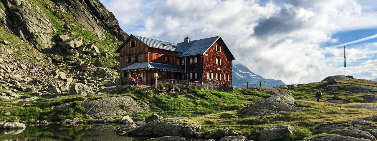
From the Tribulaunhütte the trail leads steeply uphill in a south-westerly direction on the northern slopes of the Tribulaun Massif, through rocky terrain above the mountain meadows to the Schwarze Wand and on over a stream to Mitteregg. After a short climb of around 100 vertical metres hikers reach the Bremer Hütte. This stage contains one section where there are steel ropes anchored to the rock for additional safety.
Stage 3: Bremer Hütte – Innsbrucker Hütte
Vertical ascent/descent: 845/893 metres, walking time: 6 hours, distance: 10 kilometres, highest point: 2,539 metres, difficulty: difficult
Stage three begins at the end of the Gschnitztal Valley, taking hikers from the Bremer Hütte in a northerly direction. It is here that walkers join the Stubai High Trail and cross a stream before passing the Lautersee lake and heading into the Plattental Valley. There are several exposed sections here with steel ropes anchored into the rock for safety. Follow the trail to the Pramarnspitze mountain at around 2,500 metres above sea level. The final section is then up and down over several ridges to the Pinnisjoch. It is there that you will find the Innsbrucker Hütte hut at 2,369 metres sea level with fine views of the mighty Habicht mountain.
Stage 4: Innsbrucker Hütte - Padasterjochhaus
Vertical ascent/descent: 1,124/1,255 metres, walking time: 7 hours, distance: 10 kilometres, highest point: 2,745 metres, difficulty: difficult
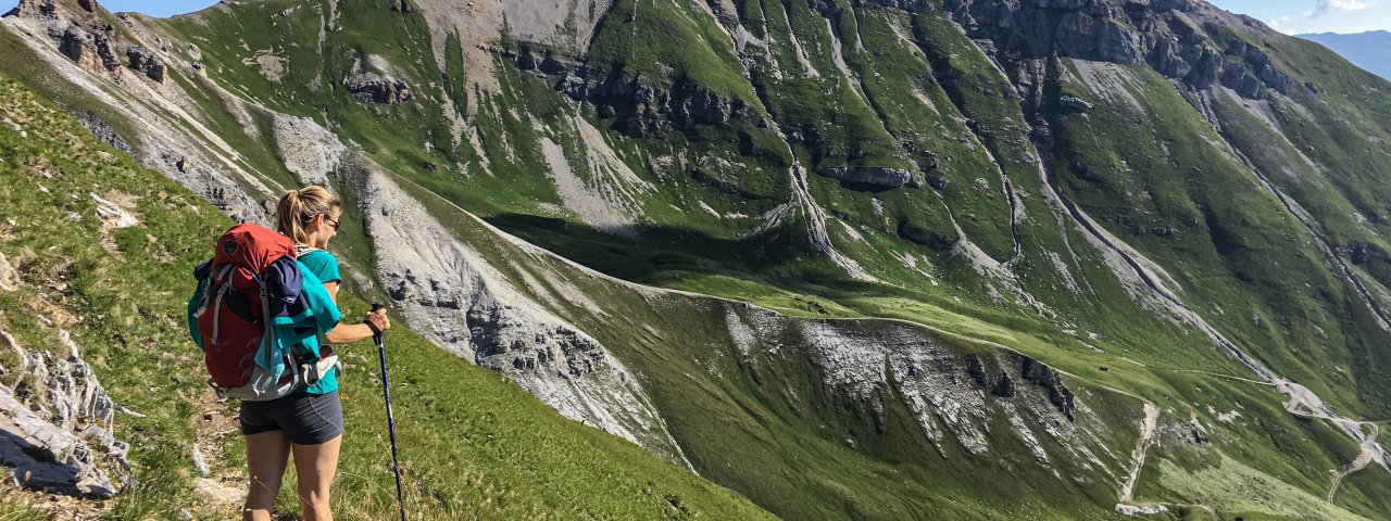
After a good night's sleep at the Innsbrucker Hütte, it is time to hit the trails again and head north to the Alfairgrube. You will be able to see the Karalm hut (serving food & drink) until shortly after you have crossed the stream. From there, take the trail north until a narrower and steeper trail branches off to the right. This is where the climb to the Kirchdachspitze begins, up over the Silbersattel ridge at 2,840 metres. The final section is through rocky terrain beneath the Hammerspitze and past a small shepherd's hut to the Padasterjochhaus.
Stage 5: Padasterjochhaus – Blaserhütte
Vertical ascent/descent: 776/828 metres, walking time: 5.5 hours, distance: 7.8 kilometres, highest point: 2,713 metres, difficulty: difficult
Stage five begins with an uphill section from the Padasterjochhaus towards the Wasenwand, leading over several impressive summits. Follow the trail beneath the Wasenwand to the Roter Kopf at 2,526 metre. After a further 200 vertical metres you will reach the Kesselspitze peak. It is then time to head towards the Kalbenjoch ridge and follow the signs for "Peilspitze". After summiting this mountain, continue through rough terrain to the Blaserhütte at the foot of the 2,241 Blaser mountain.
Stage 6: Blaserhütte – Talstation Bergeralmbahn
Vertical ascent/descent: 6/1,123 metres, walking time: 3.5 hours, distance: 8 kilometres, highest point: 2,180 metres, difficulty: intermediate
The final stage of this hike is the shortest. Form the Blaserhütte the descent first leads along a forest road heading in an easterly direction. The Blaser mountain is famous for its flowers, so you can alternatively take a steeper and narrower trail down leading through a series of meadows known as the Sanddürrenmähder. After around three hours of walking you will get back to the starting point of this hike, the bottom station of the Bergeralmbahn cable car.
Information on place

Hiking trails in this region

Navis
This walk of intermediate difficulty leads through meadows and pastures at…

Gschnitz
Mighty, majestic and magnificent, the craggy peaks of the Stubai Alps at…

Navis
With around 1,200 vertical metres of ascent, the climb up to the Kreuzjöchl…
