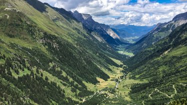
Mighty, majestic and magnificent, the craggy peaks of the Stubai Alps at the end of the Gschnitztal Valley are a sight to behold. This hike leads up to the top of one of them, the easily accessible Garklerin at 2,470 metres in altitude. The trail to the top of this beautiful mountain leads above the Sandesbach stream through forests and across meadows to the Tribulaunhütte at the foot of the mighty Ttibulaun massif. The hike begins in the village of Gschnitz (1,281 metres) at the end of the valley.

Summit Hike
Starting point
Gasthof Feuerstein, Gschnitztal
Hike to
Tribulaunhütte, Garklerin
Finishing point
Gasthof Feuerstein, Gschnitztal
Mountain chain
Stubai Alps
Length
16.8 km
Total hiking time
8h
Features
- Wheelchair-accessible Hiking Route
- Circular hike
Difficulty rating
intermediate (red mountain trails)
Altitude
2,470m 1,281m
Elevation uphill 1,183m
Vertical metres downhill 1,183m
Fitness level
Technique
Best time of year
Jan
Feb
Mar
Apr
May
Jun
Jul
Aug
Sep
Oct
Nov
Dec
* These are approximate values and recommendations. Please take your personal fitness level, technical ability and the current weather conditions into account. Tirol Werbung cannot guarantee that the information provided is correct and accepts no liability.
Public transport
- Accessible using public transport
Parking
Parking near the Gasthof Feuerstein, at the end of the official public road
Places serving food & drink
- Tribulaunhütte (open December until April and June until October)
- Gasthof Feuerstein in Gschnitz
Downloads
Trail description
This challenging but beautiful hike begins at the Gasthof Feuerstein guesthouse at the end of the Gschnitztal Valley. Follow trail 127 through a steep section of forest until the terrain flattens near the Außersandesalm (1,498 metres). East of the Sandesbach stream, continue all the way to the edge of the forest heading uphill. You will then pass the Valtißalm (1,663 metres) before reaching the Tribulaunhütte (2,064 metres), a mountain hut perched high above the end of the valley. Stop here for a snack and a drink before continuing in a large arc along the foot of the Pflerscher Tribulaun (3,097 metres) and the Gschnitzer Tribulaun (2,946 metres) as well as the Goldkappl (2,793 metres) mountains. It is then time to head north, up onto the grassy ridge (2,259 metres). This is where the ascent to the top of the Garklerin begins. From the top of the peak you can enjoy fine views of the north-facing slopes of the Pflerscher Tribulaun and the Gschnitzer Tribulaun as well as the shimmering glaciers in the distance and the towering Feuerstein mountain (3,268 metres).
The descent leads back down the same narrow mountain path to the grassy ridge, then down left along the western side of the Sandbach river into the valley to the starting point at the Gasthof Feuerstein.
Information on place

Hiking trails in this region
Steinach
Mighty mountains, lush meadows and cosy huts are the reward for almost 60…

Gschnitz
Located at 2,369 metres above sea level, between the Gschnitztal Valley and…

Scharnitz
From the rushing Isar river to the Adriatic Sea, from the Tirolean…
