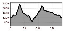
Interaktive Karte öffnenDiesen POI auf der interaktive Karte öffnenHöhenprofilAndreas-Traxl-Training Tour.gpx
Das Falzthurntal wirkt aufgrund der bunten Blumenwiesen und der markanten Bergwelt sanft und schroff zugleich. © Achensee Tourismus Handbike ride Pertisau - FalzthurnalmSchwierigkeit:difficultLänge:3.3 kmDauer:1:00 hHöhenmeter bergauf:105 mZur BiketourZur Biketour: Handbike ride Pertisau - Falzthurnalm
der Weg am Ufer des Achensees ist ein tolles Handbiker Areal © Achensee Tourismus Handbike ride Maurach - AchenkirchSchwierigkeit:mediumLänge:9.0 kmDauer:1:00 hHöhenmeter bergauf:35 mZur BiketourZur Biketour: Handbike ride Maurach - Achenkirch
Dolomitenrundfahrt © Expa / Groder Around the Lienz DolomitesSchwierigkeit:mediumLänge:112.0 kmDauer:3:30 hHöhenmeter bergauf:1,870 mZur BiketourZur Biketour: Around the Lienz Dolomites
Innbrücke bei Jenbach © Tirol Werbung/Frank Bauer Innradweg TVB Silberregion KarwendelSchwierigkeit:easyLänge:42.9 kmDauer:3:00 hHöhenmeter bergauf:183 mZur BiketourZur Biketour: Innradweg TVB Silberregion Karwendel
OD Trails Oberndorf in Tirol 5.jpg © Mirja Geh OD TrailsÖffnungszeiten:openSchwierigkeit:mediumZur BiketourZur Biketour: OD Trails
Lakata Trail © bikeboard/Roland Kachelhauser Alban Lakata Trail No. 142Schwierigkeit:mediumLänge:2.0 kmDauer:0:20 hHöhenmeter bergauf:10 mZur BiketourZur Biketour: Alban Lakata Trail No. 142
BergkasteltrailÖffnungszeiten:openSchwierigkeit:mediumLänge:5.5 kmZur BiketourZur Biketour: Bergkasteltrail
Navis, Stöcklalm_Tirol Werbung_Bitter Johannes_Navis (1) © Tirol Werbung | Johannes Bitter Naviser mountainbike Naviser Pasture RoundSchwierigkeit:mediumLänge:14.0 kmDauer:3:00 hHöhenmeter bergauf:811 mZur BiketourZur Biketour: Naviser mountainbike Naviser Pasture Round
Käsealm Straubing © Ferienregion Hohe Salve Käsealm Straubing past WindauSchwierigkeit:mediumLänge:19.8 kmDauer:2:30 hHöhenmeter bergauf:270 mZur BiketourZur Biketour: Käsealm Straubing past Windau
471 Kaltenbach - WedelhütteSchwierigkeit:mediumLänge:36.9 kmDauer:5:00 hHöhenmeter bergauf:1,759 mZur BiketourZur Biketour: 471 Kaltenbach - Wedelhütte
TVB Bike 204.jpg © Nikola Radovic - NKLRDVC photo Wetterstein trail red - Fifty/FiftyÖffnungszeiten:openSchwierigkeit:mediumLänge:1.2 kmZur BiketourZur Biketour: Wetterstein trail red - Fifty/Fifty
Miesberg - SeerundeSchwierigkeit:easyLänge:13.2 kmDauer:1:30 hHöhenmeter bergauf:130 mZur BiketourZur Biketour: Miesberg - Seerunde
Labalm KirchbergSchwierigkeit:mediumLänge:26.0 kmDauer:3:00 hHöhenmeter bergauf:450 mZur BiketourZur Biketour: Labalm Kirchberg
Ehenbichler Alm mit Blick auf Abendspitze © LIGHTHOUSE | Stefan Mayr Fotografie Berwang - To the Sennalpe RaazSchwierigkeit:mediumLänge:16.6 kmDauer:3:30 hHöhenmeter bergauf:768 mZur BiketourZur Biketour: Berwang - To the Sennalpe Raaz
Lisi Osl TrailÖffnungszeiten:openSchwierigkeit:mediumLänge:2.3 kmDauer:0:20 hZur BiketourZur Biketour: Lisi Osl Trail
Mountainbike training parcoursÖffnungszeiten:openSchwierigkeit:easyLänge:500 mDauer:0:07 hHöhenmeter bergauf:12 mZur BiketourZur Biketour: Mountainbike training parcours
Gaislachalm - Sölden © Jakob Falkner Bike Route Gaislach (644)Öffnungszeiten:openSchwierigkeit:mediumLänge:18.7 kmDauer:3:04 hHöhenmeter bergauf:835 mZur BiketourZur Biketour: Bike Route Gaislach (644)
OLLWEITE LINE © Rudi Wyhlidal Ollweite Line (6010)Öffnungszeiten:openSchwierigkeit:mediumLänge:6.8 kmDauer:1:00 hZur BiketourZur Biketour: Ollweite Line (6010)
Sölden, Fernar Trail crop (2) © Tirol Werbung | Sebastian Schels Fernar Trail (6041)Schwierigkeit:difficultLänge:6.0 kmDauer:0:49 hHöhenmeter bergauf:18 mZur BiketourZur Biketour: Fernar Trail (6041)
trailcenter ötztaler höhe / wolfsrudel trail_img_80972192 © Ötztal Trailcenter Ötztaler Höhe / Wolfsrudel TrailÖffnungszeiten:openLänge:1.4 kmDauer:0:24 hHöhenmeter bergauf:29 mZur BiketourZur Biketour: Trailcenter Ötztaler Höhe / Wolfsrudel Trail
Kleble Alm Trail © Ötztal Kleble Alm Trail (699)Schwierigkeit:mediumLänge:2.2 kmDauer:0:30 hZur BiketourZur Biketour: Kleble Alm Trail (699)
Ötztaler Radweg © Ötztal Tourismus Büro Oetz Ötztal Cycle Trail (11)Öffnungszeiten:openSchwierigkeit:mediumLänge:60.2 kmDauer:6:00 hHöhenmeter bergauf:915 mZur BiketourZur Biketour: Ötztal Cycle Trail (11)
Leiterberg Trail © Rudi Wyhlidal Leiterberg Trail (672)Öffnungszeiten:openSchwierigkeit:mediumLänge:4.7 kmDauer:0:45 hHöhenmeter bergauf:5 mZur BiketourZur Biketour: Leiterberg Trail (672)
Feedback geben und besondere Urlaubserlebnisse gewinnen!Hier geht's zur UmfrageHier geht's zur Umfrage


.jpg")
")


_FULL110.jpg")


")


