Road bike tour World Cup Circuit, Tour Nr. 6

Route length: 66.4 km
Duration: 2:30 h

A wonderful tour following in the tracks of the Cycling World Cup behind the “Kaiser” with views of its famous climbing peaks.

Tour information

  • Length: 66.4 km
  • Duration: 2:30 h
  • Elevation uphill:740 hm
Highest point799 m

Starting point

Kitzbühel - Stadtzentrum

Finishing point

Kitzbühel - Stadtzentrum

Features

  • Circular route

Best time of year

  • January
  • February
  • March
  • April
  • May
  • June
  • July
  • August
  • September
  • October
  • November
  • December

Equipment

road bike, helmet, clothing according to weather, light wind jacket recommended, sun blocker and sufficient drinks

Description

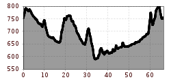
From the centre of Kitzbühel take the same route as the Kitzbühel Circuit (No. 1) via Reith and then Rerobichl (750 m) to Oberndorf and past Sperten | Weitau to St. Johann in Tirol (659 m above sea level). At the roundabout join the B178 and after 500 m at the M-Preis supermarket turn left onto the old secondary road. The legendary ascent to Gasteig follows (757 m). After a wonderful ride over the plateau passing Gasteig and Griesenau head towards Schwendt. The centre is then reached along the short but sweet “Schwendter Bichl” (720 m). A rapid descent to Kössen (588 m) then at the roundabout turn right towards Erpfendorf | St. Johann. Follow the Erpfendorfer Straße until just before Erpfendorf. Here, before the bridge over the Großache, turn right into the old secondary road and follow the quiet road to St. Johann. Cross the federal road through the underpass and head towards the centre and the St. Johann cable car station. From here follow the wonderful Römerweg along the west side of the Kitzbüheler Horn to Kitzbühel (see Kitzbühel Circuit).

More tours in the surrounding area

  • Bifang Tour

    Opening hours: closed
    Difficulty: easy
    Length: 10.4 km Duration: 1:00 h Elevation uphill: 320 m
  • Lichte Trail 882

    Opening hours: closed
    Difficulty: difficult
    Length: 3.4 km Duration: 0:15 h Elevation uphill: 5 m
  • Högtrail 7081

    Opening hours: open
    Difficulty: easy
    Length: 3.8 km
  • 401 | Zillertaler Höhenstraße

    Difficulty: difficult
    Length: 52.6 km Duration: 7:40 h Elevation uphill: 1,890 m
  • Ehrwalder Alm Seebensee

    Difficulty: medium
    Length: 9.0 km Duration: 2:30 h Elevation uphill: 630 m
  • Stubai Radroute 19

    Opening hours: closed
    Difficulty: easy
    Length: 24.0 km Elevation uphill: 364 m
  • Milky Way

    Opening hours: closed
    Difficulty: easy
    Length: 2.9 km
  • Innradweg Ötztal

    Difficulty: easy
    Length: 50.5 km Duration: 3:45 h Elevation uphill: 728 m
  • Lechradweg

    Length: 244.6 km Duration: 18:00 h Elevation uphill: 1,702 m
  • Peter Sagan Trail No. 141

    Difficulty: medium
    Length: 5.0 km Duration: 0:30 h Elevation uphill: 90 m
  • Bannwaldsee circuit

    Difficulty: medium
    Length: 94.5 km Duration: 3:45 h Elevation uphill: 877 m
  • Leiterberg Trail (672)

    Opening hours: open
    Difficulty: medium
    Length: 4.7 km Duration: 0:45 h Elevation uphill: 5 m
  • Fernar Trail (6041)

    Difficulty: difficult
    Length: 6.0 km Duration: 0:49 h Elevation uphill: 18 m
  • Leithetrail 7128

    Opening hours: open
    Difficulty: easy
    Length: 4.3 km
  • Ötztal Cycle Trail (11)

    Opening hours: closed
    Difficulty: medium
    Length: 60.2 km Duration: 6:00 h Elevation uphill: 915 m
Newsletter

The mountain is calling? So does our newsletter!

In our monthly newsletter we reveal the best holiday tips for Tyrol.