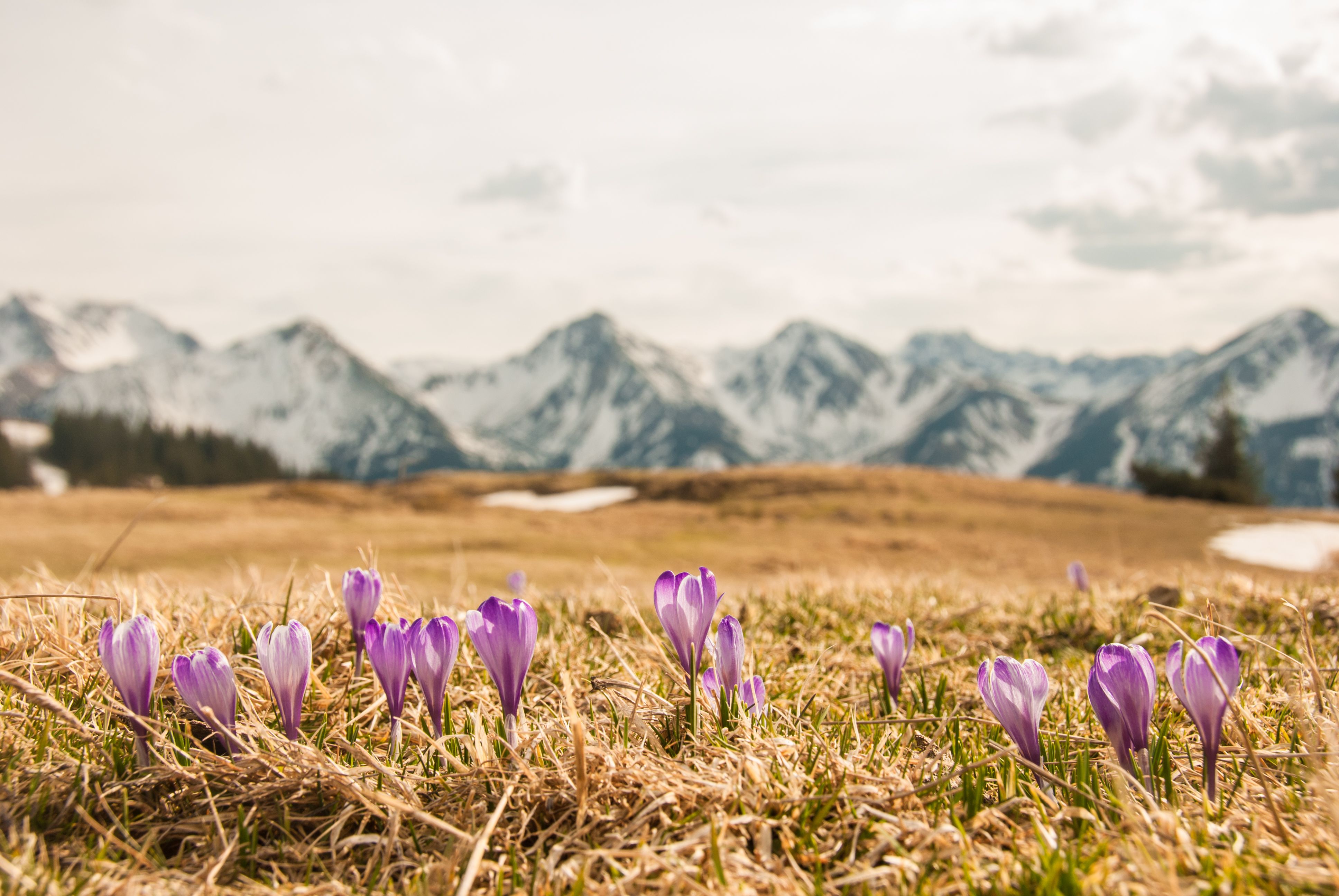
Hiking

Hikes to 1000-metre peaks

Tyrol is known for its high mountains. Peaks above the 2,000 and 3,000 metre mark characterise the topography of the region. This means that those mountains which are 'only' 1,000 metres or so high are often less popular with locals and visitors alike. Wrongly so! In fact, these peaks offer things many of their higher cousins cannot - snow-free conditions in early summer and autumn, great views of the 'big ones', potential for evening, sunrise or sunset hikes due to shorter ascents. So let's go and show those 1000-metre mountains some much-deserved love!
Wanderweg vom Hochstrickl auf Gratlspitze mit zwei Personen
    • Schwierigkeitmedium
    • Länge7.4 km
    • Dauer3:30 h
    • Höhenmeter bergauf700 m
    • OrtWalchsee / Chiemgau Alps
  • Trails through a lovely alpine landscape
  • Wilder and Zahmer Kaiser as if on a platter
  • Tasting the cheese from the Burgeralm, famous throughout Tyrol
  • Finish with a dip in the Walchsee lake
Mehr erfahren
    • Schwierigkeitmedium
    • Länge16.0 km
    • Dauer6:00 h
    • Höhenmeter bergauf810 m
    • OrtScharnitz / Karwendel
  • Central location with rare views of the Karwendel mountains
  • Little-visited summit
  • Dream place Oberbrunnalm: Culinary and scenic top
Mehr erfahren
  • Fantastic views of the Alpine foothills and the striking Tannheim and Allgäu mountains
  • South-facing and therefore often snow-free even in the off-season
  • Magnificent crocus blossom in spring along the ascent
Mehr erfahren
    • Schwierigkeitmedium
    • Länge16.3 km
    • Dauer6:15 h
    • Höhenmeter bergauf1,065 m
    • Ort / Karwendel
  • Perfect view over the entire Achensee and into the Karwendel mountains
  • Varied hike with a quiet and a well-frequented side
  • two refreshment options with Weißenbachalm or Bärenbadalm
Mehr erfahren
    • Schwierigkeitmedium
    • Länge8.6 km
    • Dauer4:30 h
    • Höhenmeter bergauf779 m
    • OrtBrandenberg / Brandenberg Alps (Rofan)
  • Three summits in one go
  • Deep views of the Inntal valley and distant views as far as the glaciated main ridge
  • One of the most striking summit crosses in Tyrol stands on the Plessenberg
Mehr erfahren
    • Schwierigkeitmedium
    • Länge7.9 km
    • Dauer3:00 h
    • Höhenmeter bergauf513 m
    • OrtWildschönau / Kitzbühel Alps
  • Wonderful picnic spots at the summit of the Kragenjoch
  • Easily accessible, family-friendly summit
  • Regional specialities at the Achentalalm, Wildschönauer Schmalznudeln every Wednesday
Mehr erfahren
    • Schwierigkeitmedium
    • Länge8.6 km
    • Dauer4:00 h
    • Höhenmeter bergauf600 m
    • OrtThiersee / Brandenberg Alps (Rofan)
  • on the Pendling 1,000 metres below Kufstein and views as far as the Großglockner
  • Almost directly at the summit: the Pendlinghaus in a fantastic panoramic location (open from the beginning of July to November)
  • Around the Kalaalm (open from the beginning of May) exceptionally high occurrence of snow lilies
Mehr erfahren
    • Schwierigkeitmedium
    • Länge9.9 km
    • Dauer4:00 h
    • Höhenmeter bergauf741 m
    • OrtThaur / Karwendel
  • One of the most beautiful views of Innsbruck from the summit
  • several ascent options from the forest path to the steep forest and meadow path
  • the Thaurer Alm as a refreshment stop not far from the summit
Mehr erfahren
    • Schwierigkeitmedium
    • Länge4.6 km
    • Dauer2:30 h
    • Höhenmeter bergauf479 m
    • OrtBrixlegg / Kitzbühel Alps
  • 360-degree panoramic view of the Gratlspitze with a view of 26 church towers and over 800 mountain peaks
  • one of the most beautiful summit benches in Tyrol
  • Local mountain of Alpbach, perhaps the most beautiful village in Austria
Mehr erfahren
    • Schwierigkeitmedium
    • Länge21.0 km
    • Dauer9:00 h
    • Höhenmeter bergauf1,170 m
    • OrtKirchdorf in Tirol / Kaiser Mountains
  • Most beautiful view of the historic north faces of the Wilder Kaiser
  • Pavilion power spot on the Stripsenkopf summit
  • Scenic ridge crossing between the two peaks
  • With the Kaiserbachtal and Kaisertal valleys, two of the most charming mountain valleys in Tyrol lie at your feet
Mehr erfahren
    • Schwierigkeitmedium
    • Länge16.1 km
    • Dauer7:00 h
    • Höhenmeter bergauf954 m
    • OrtSt. Johann in Tirol / Kaiser Mountains
  • spannender, anspruchsvoller Anstieg über den Maiklsteig
  • Sehenswürdigkeiten Einsiedelei und Gmailkapelle in die Route integrierbar
  • Kraftorte Ursulakreuz und Schleierwasserfall
  • tolle Tiefblicke auf das St. Johanner Becken
Mehr erfahren
    • Schwierigkeitmedium
    • Länge20.5 km
    • Dauer7:30 h
    • Höhenmeter bergauf1,120 m
    • OrtAchenkirch am Achensee / Karwendel
  • Rather lonely, as long climbs, beautiful bike & hike summit
  • Contrast between the green Vorkarwendel and the rugged Karwendel ranges
  • Rustic alpine pastures and lush flower meadows
Mehr erfahren
    • Schwierigkeitmedium
    • Länge15.7 km
    • Dauer6:30 h
    • Höhenmeter bergauf859 m
    • OrtKirchberg in Tirol / Kitzbühel Alps
  • Box seat with a view of the Grosser Rettenstein, the most striking peak in the Kitzbühel Alps
  • abundance of flowers around the summit, called "the blooming mountain" by locals
  • Varied circular tour, beautiful panoramic hike along the ridge
Mehr erfahren
    • Schwierigkeitmedium
    • Länge18.1 km
    • Dauer6:15 h
    • Höhenmeter bergauf762 m
    • OrtSt. Johann in Tirol / Kitzbühel Alps
  • Wonderful panoramic location right between the Wilder Kaiser, Kitzbüheler Horn and the Loferer Steinberge mountains
  • beautiful alpine plateau of the Kalksteinalmen
  • Many trail options in the Kalksteinstock
Mehr erfahren
    • Schwierigkeitdifficult
    • Länge12.6 km
    • Dauer5:45 h
    • Höhenmeter bergauf797 m
    • OrtErl / Chiemgau Alps
  • Panoramic summit on the edge of the Alps, view from the foothills of the Alps to the Hohe Tauern
  • Beautiful summit area with chapel and seating areas
  • Blumenberg
  • Many lovely places to stop for refreshments along the way
Mehr erfahren
    • Öffnungszeitenopen
    • Schwierigkeitmedium
    • Länge15.0 km
    • Dauer7:00 h
    • Höhenmeter bergauf1,120 m
    • OrtEbbs / Kaiser Mountains
  • Panoramic view over the Inn Valley and the Kaiser Mountains
  • Idyllic forests and alpine meadows
  • Can be easily combined with a stop at the Vorderkaiserfeldenhütte
Mehr erfahren
    • Schwierigkeitmedium
    • Länge14.0 km
    • Dauer6:00 h
    • Höhenmeter bergauf876 m
    • OrtZöblen / Allgäu Alps
  • Complete panoramic view over the Tannheimer Tal and the surrounding mountains
  • Lohmoos-Hochmoor as a scenic highlight and special natural area
  • Varied mix of trails and a summit path close to the ridge
Mehr erfahren

More about 1000-metre mountains

This might also interest you:

Tirol Newsletter

The mountain is calling? So does our newsletter!

In our monthly newsletter we reveal the best holiday tips for Tyrol.