Mountain hikes Around the Thurntaler

Difficulty ratings: easy
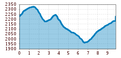
Route length: 9.8 km
Duration: 3:30 h

Around the Thurntaler

Tour information

  • Requirement: easy
  • Length: 9.8 km
  • Duration: 3:30 h
  • Elevation uphill:460 hm
  • Elevation downhill:460 hm
Highest point509 m

Starting point

Mountain rescue hut cable railway Thurntaler

Finishing point

Mountain rescue hut cable railway Thurntaler
  • Fitness level 3 / 6
  • Technique 3 / 6

Features

  • Circular route
  • Suitable for families

Best time of year

  • January
  • February
  • March
  • April
  • May
  • June
  • July
  • August
  • September
  • October
  • November
  • December

Description

From the Thurntaler mountain station via route 10b to Äußere Hochalm. Continue on route 10 to the mountain ridge. The summit is to the right, Astatt Sattel is to the left. From there continue via route 4 down to Hintere Hochalmhütte on the Villgraten side. On route 10b via Hofilet Alm back to Thurntaler Rast, to Gadein mountain restaurant and back to Thurntaler mountain station.

This hiking route is also possible to do from the hut Thurntaler Rast (with car reachable).

Getting here

  • Arrival by public transport

    Mit dem Bus bis zur Haltestelle "Panzendorf Abzw. Villgraten"

  • Parking

    Parkplatz Seilbahn Thurntaler

More tours in the surrounding area

Newsletter

The mountain is calling? So does our newsletter!

In our monthly newsletter we reveal the best holiday tips for Tyrol.