Mountain hikes Finkenberg - Dornau - Dornauhof - Sportplatz - Dornau

Finkenberg, Zillertal / Zillertal Alps
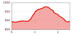
Route length: 2.5 km
Duration: 1:00 h

Tour information

  • Length: 2.5 km
  • Duration: 1:00 h
  • Elevation uphill:115 hm
  • Elevation downhill:115 hm
Highest point975 m

Starting point

Bushaltestelle Finkenberg Teufelsbrücke

Finishing point

Bushaltestelle Finkenberg Teufelsbrücke

Features

  • Circular route

Best time of year

  • January
  • February
  • March
  • April
  • May
  • June
  • July
  • August
  • September
  • October
  • November
  • December
Source: Zillertal Tourismus GmbH

Description

From the Teufelsbrücke (Devil's Bridge) in the hamlet of Dornau go straight ahead until Hotel Dornauhof (house no. 308). After the hotel, turn right into the access road and take the path no. 33 till the junction of the path no. 33b. Follow path no. 33b until the sports field. From here take the road (path no. 34) back to the starting point.

Weather

Today

cloudy
7°C/1°C
5%0l5 km/h

Wed

partly Cloudy
8°C/1°C
5%0l5 km/h

Thu

clear sky
9°C/0°C
0%0l5 km/h
Go to weather forecast

More tours in the surrounding area

Newsletter

The mountain is calling? So does our newsletter!

In our monthly newsletter we reveal the best holiday tips for Tyrol.