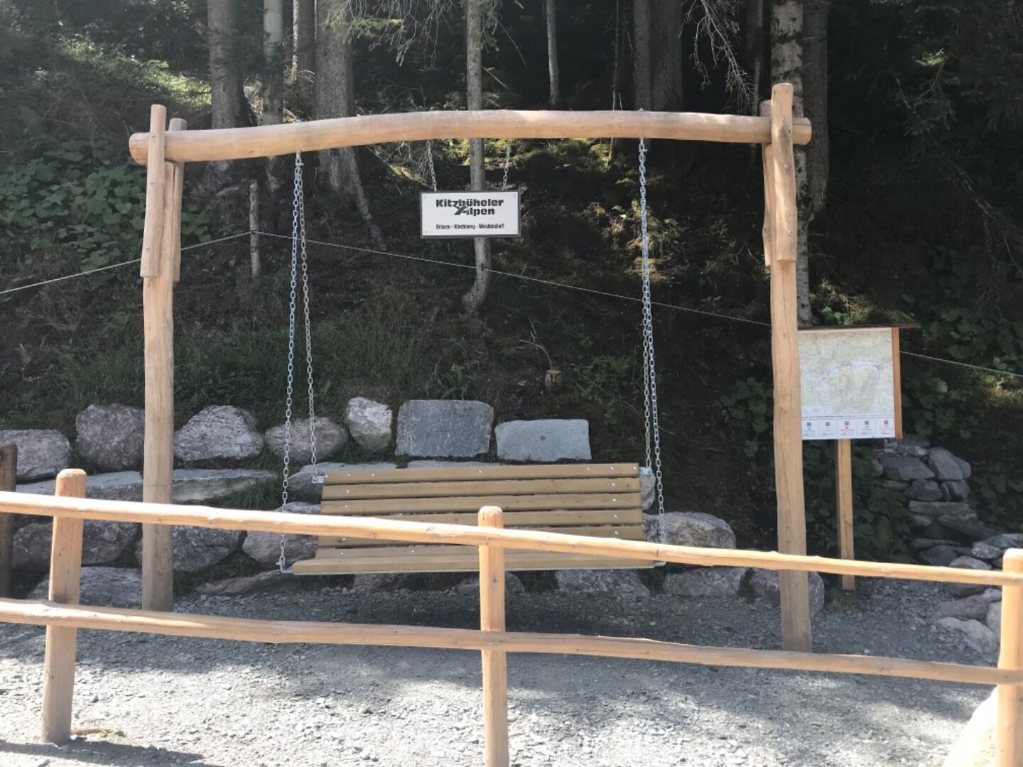
Open interactive mapOpen this POI on the interactive mapElevation profiledownloadHängebank zur Brixenbachalm.gpx
BrixenbachalmOpening hours:Open todayPlace:Brixen im Thale:Alpine pasture / hut / mountain restaurantsee restaurant detailssee restaurant details: Brixenbachalm
Kaiserjochhaus © Lechtal Tourismus Lechtaler Höhenweg: 3. Etappe Kasierjochhaus-Ansbacher HütteDifficulty:difficultLength:11.3 kmDuration:6:45 hElevation uphill:1,010 mSee trailSee trail: Lechtaler Höhenweg: 3. Etappe Kasierjochhaus-Ansbacher Hütte
Alpine hike to Lienzer HütteDifficulty:easyLength:6.8 kmDuration:2:30 hElevation uphill:297 mSee trailSee trail: Alpine hike to Lienzer Hütte
Kotalm Mitterleger - dahinter die mächtigen Klobenjoch Wände © Achensee Tourismus Achenkirch - Köglalm - Kotalm Mitterleger - Kotalm Niederleger – AchenkirchDifficulty:mediumLength:9.6 kmDuration:5:00 hElevation uphill:720 mSee trailSee trail: Achenkirch - Köglalm - Kotalm Mitterleger - Kotalm Niederleger – Achenkirch
swiss-track02-c-npht-martin-kurzthaler.jpeg © Nationalpark Hohe Tauern / Martin Kurzthaler Rollitour with Swiss TracDifficulty:easyLength:3.2 kmDuration:1:30 hElevation uphill:135 mSee trailSee trail: Rollitour with Swiss Trac
imagemeta.apiv2.1593523029518 © TVB Stubai Sulzenau Hütte - Blaue Lacke und GrünauseeDifficulty:mediumLength:3.2 kmDuration:1:07 hElevation uphill:117 mSee trailSee trail: Sulzenau Hütte - Blaue Lacke und Grünausee
Lechtal, Lechtaler Höhenweg, Steinsee_Tirol Werbung_Schels Sebastian_No location given (4) © Tirol Werbung | Sebastian Schels Lechtaler HöhenwegDifficulty:difficultLength:84.5 kmDuration:45:00 hElevation uphill:6,773 mSee trailSee trail: Lechtaler Höhenweg
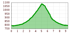
Kitzbüheler Alpen_KATwalk2018-Etappe4_Erwin Haiden07.jpg © Erwin Haiden KAT WALK ALPINEDifficulty:mediumLength:113.0 kmDuration:45:00 hElevation uphill:6,300 mSee trailSee trail: KAT WALK ALPINE
Stuttgarter HütteDifficulty:mediumLength:12.3 kmDuration:5:30 hElevation uphill:1,124 mSee trailSee trail: Stuttgarter Hütte
Kaiserjochhaus © Lechtal Tourismus Lechtaler Höhenweg: 3. Etappe Kasierjochhaus-Ansbacher HütteDifficulty:difficultLength:8.3 kmDuration:3:30 hElevation uphill:490 mSee trailSee trail: Lechtaler Höhenweg: 3. Etappe Kasierjochhaus-Ansbacher Hütte
Weitwanderung Peter Habeler Runde © Archiv TVB Mayrhofen Long-distance hike: Peter Habeler RundeDifficulty:difficultLength:56.7 kmDuration:25:00 hElevation uphill:3,705 mSee trailSee trail: Long-distance hike: Peter Habeler Runde
Schloss Bruck Lienz © TVBOsttirol Walter Mair Trail Lienzer TalbodenDifficulty:easyLength:48.0 kmDuration:15:40 hElevation uphill:1,280 mSee trailSee trail: Walter Mair Trail Lienzer Talboden
Gallruth Stollenwanderung_Daniel Zangerl.jpg © Daniel Zangerl Kaunerberger WasserwegDifficulty:mediumLength:15.2 kmDuration:6:00 hElevation uphill:935 mSee trailSee trail: Kaunerberger Wasserweg
Koasatrail-Etappe2 Region St. Johann in Tirol Kirchdorf Oberndorf © Sportalpen Koasa Trail Stage 2Difficulty:mediumLength:11.8 kmDuration:7:15 hElevation uphill:1,078 mSee trailSee trail: Koasa Trail Stage 2
Gogles Alm © Gogles Alm/Joachim Hike to Gogles AlmDifficulty:mediumLength:8.9 kmDuration:3:15 hElevation uphill:550 mSee trailSee trail: Hike to Gogles Alm
Wildschönau Niederau Foisching © Hannes Dabernig Niederau - Foisching HutDifficulty:easyLength:6.5 kmDuration:2:15 hElevation uphill:253 mGo to winter hikeGo to winter hike: Niederau - Foisching Hut
Summit Hike to Lodron from Gasthof JägerhäuslDifficulty:mediumLength:20.0 kmDuration:8:30 hElevation uphill:1,125 mSee trailSee trail: Summit Hike to Lodron from Gasthof Jägerhäusl
Lourdesgrotte - Kirchdorf Region St. Johann in Tirol © Region St. Johann in Tirol Einsiedelei Hermitage - Gmail Chapel - Lourdes GrottoDifficulty:mediumLength:6.3 kmDuration:2:30 hElevation uphill:325 mSee trailSee trail: Einsiedelei Hermitage - Gmail Chapel - Lourdes Grotto
©-TVB-Tiroler-Oberland-Kaunertal-Michael-Veit-Klima-Führer-2018-Talwanderweg-Vergötschen-Platz-2018 © Michael Veit Talwanderweg KaunertalDifficulty:easyDuration:2:30 hElevation uphill:295 mSee trailSee trail: Talwanderweg Kaunertal
Pforzheimer-Hütte-mit-Zischgeles.jpg © Pforzheimer Hütte The Sellrain Valley Mountain Hut Tour: stage 4Difficulty:mediumLength:5.8 kmDuration:4:00 hElevation uphill:460 mSee trailSee trail: The Sellrain Valley Mountain Hut Tour: stage 4
The Sellrain Valley Mountain Hut Tour: stage 6Difficulty:difficultLength:9.4 kmDuration:4:00 hElevation uphill:730 mSee trailSee trail: The Sellrain Valley Mountain Hut Tour: stage 6
Westfalenhaus-Sommer.jpg © Westfalenhaus The Sellrain Valley Mountain Hut Tour: stage 3Difficulty:difficultLength:6.9 kmDuration:5:00 hElevation uphill:770 mSee trailSee trail: The Sellrain Valley Mountain Hut Tour: stage 3
Potsdamer-Hütte.jpg © Innsbruck Tourismus The Sellrain Valley Mountain Hut Tour: stage 1Difficulty:mediumLength:9.3 kmDuration:3:30 hElevation uphill:1,101 mSee trailSee trail: The Sellrain Valley Mountain Hut Tour: stage 1
Wildseeloderhaus © Toni Niederwieser WaiWi - from Waidring to the WildseeloderDifficulty:mediumLength:50.0 kmDuration:24:00 hElevation uphill:3,200 mSee trailSee trail: WaiWi - from Waidring to the Wildseeloder
The Sellrain Valley Mountain Hut Tour: stage 5Difficulty:difficultLength:12.3 kmDuration:9:00 hElevation uphill:1,357 mSee trailSee trail: The Sellrain Valley Mountain Hut Tour: stage 5
Bergbahn Pillersee - Flecken - BuchensteinwandDifficulty:mediumLength:6.0 kmElevation uphill:596 mSee trailSee trail: Bergbahn Pillersee - Flecken - Buchensteinwand
Give feedback for a chance to win a special holiday experience!Click here for the surveyClick here for the survey


")


 © Bergbahn Pillersee.jpg")
