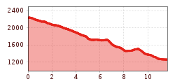
Open interactive mapOpen this POI on the interactive mapElevation profileKönigsleiten - Larmach Alm - Aeilschlag - Gerlos.gpx
Sillianer Hütte © Peter Leiter Carnic altitude trail. Stage 1: Arnbach - Sillianer HütteDifficulty: easy Length: 9.5 km Elevation uphill: 1,350 m See trailSee trail: Carnic altitude trail. Stage 1: Arnbach - Sillianer Hütte
Europakreuz auf der Gr. Kinigat © A. Goller Carnic altitude trail. Stage 3: Obstansersee Hütte – PorzehütteDifficulty: medium Length: 11.3 km Duration: 6:00 h Elevation uphill: 650 m See trailSee trail: Carnic altitude trail. Stage 3: Obstansersee Hütte – Porzehütte
2019_best-of-zillertal_image_stummerberg_bike-and-hike_level26_web_20 (1).jpg © (c) Ferienregion Fügen-Kaltenbach im Zillertal, level26 Hamberg (2095m) from the Gasthof Almluft (Trail No. 37)Difficulty: medium Length: 9.4 km Duration: 4:45 h Elevation uphill: 865 m See trailSee trail: Hamberg (2095m) from the Gasthof Almluft (Trail No. 37)
Kreuzwiese_c8e91882528c18c36b38216f9f5e6705 © Kreuzwiesenalm Foodie TrailDifficulty: easy Length: 3.0 km Duration: 1:39 h Elevation uphill: 210 m See trailSee trail: Foodie Trail
Sillianer Hütte © TVBOsttirol Carnic altitude trail. Stage 2: Sillianer Hütte- Obstansersee HütteDifficulty: medium Length: 8.7 km Elevation uphill: 503 m See trailSee trail: Carnic altitude trail. Stage 2: Sillianer Hütte- Obstansersee Hütte
Württemberger Haus 2.220m © Roman Huber Zams - Württemberger HausDifficulty: medium Length: 10.1 km Duration: 11:20 h Elevation uphill: 1,554 m See trailSee trail: Zams - Württemberger Haus
Zillertal, Kaltenbach, Wedelhütte_Tirol Werbung_Bauer Frank_Kaltenbach © Tirol Werbung | Frank Bauer Mountain Hike to the WedelhütteDifficulty: medium Length: 3.0 km Duration: 3:00 h Elevation uphill: 490 m See trailSee trail: Mountain Hike to the Wedelhütte
Mountain station Spieljochbahn - Hochfügen Difficulty: medium Length: 12.2 km Duration: 4:00 h Elevation uphill: 270 m See trailSee trail: Mountain station Spieljochbahn - Hochfügen
Gallruth Stollenwanderung_Daniel Zangerl.jpg © Daniel Zangerl Kaunerberger WasserwegDifficulty: medium Length: 15.2 km Duration: 6:00 h Elevation uphill: 935 m See trailSee trail: Kaunerberger Wasserweg
Wildschönau Niederau Foisching Rotwild Winter 2.jpg © Hannes Dabernig Niederau - Foisching HutDifficulty: easy Length: 6.5 km Duration: 2:15 h Elevation uphill: 253 m Go to winter hikeGo to winter hike: Niederau - Foisching Hut
Wildschönau Niederau Markbachjoch Kapelle Winter.jpg © Wildschönau Tourismus Winterwanderung Markbachjoch - NiederauDifficulty: medium Length: 10.5 km Duration: 4:00 h Elevation uphill: 56 m Go to winter hikeGo to winter hike: Winterwanderung Markbachjoch - Niederau
Summit Hike to Lodron from Gasthof JägerhäuslDifficulty: medium Length: 20.0 km Duration: 8:30 h Elevation uphill: 1,125 m See trailSee trail: Summit Hike to Lodron from Gasthof Jägerhäusl
©-TVB-Tiroler-Oberland-Kaunertal-Michael-Veit-Klima-Führer-2018-Talwanderweg-Vergötschen-Platz-2018 © Michael Veit Talwanderweg KaunertalDifficulty: easy Duration: 2:30 h Elevation uphill: 295 m See trailSee trail: Talwanderweg Kaunertal
Panoramic tour Hochzeiger – Sechszeiger – Kalbenalm - Gondola top stationDifficulty: medium Length: 7.2 km Duration: 5:00 h Elevation uphill: 580 m See trailSee trail: Panoramic tour Hochzeiger – Sechszeiger – Kalbenalm - Gondola top station
Nons-Alm-712x533-650x488.jpg © Silberregion Karwendel Winter walk at Hüttegg am WeerbergDifficulty: easy Length: 8.0 km Duration: 2:50 h Elevation uphill: 313 m See trailSee trail: Winter walk at Hüttegg am Weerberg
Wildseeloderhaus © Toni Niederwieser WaiWi - from Waidring to the WildseeloderDifficulty: medium Length: 50.0 km Duration: 24:00 h Elevation uphill: 3,200 m See trailSee trail: WaiWi - from Waidring to the Wildseeloder
The Sellrain Valley Mountain Hut Tour: stage 6Difficulty: difficult Length: 9.4 km Duration: 4:00 h Elevation uphill: 730 m See trailSee trail: The Sellrain Valley Mountain Hut Tour: stage 6
Bergbahn Pillersee - Flecken - BuchensteinwandDifficulty: medium Length: 6.0 km Elevation uphill: 596 m See trailSee trail: Bergbahn Pillersee - Flecken - Buchensteinwand
Westfalenhaus-Sommer.jpg © Westfalenhaus The Sellrain Valley Mountain Hut Tour: stage 3Difficulty: difficult Length: 6.9 km Duration: 5:00 h Elevation uphill: 770 m See trailSee trail: The Sellrain Valley Mountain Hut Tour: stage 3
Potsdamer-Hütte.jpg © Innsbruck Tourismus The Sellrain Valley Mountain Hut Tour: stage 1Difficulty: medium Length: 9.3 km Duration: 3:30 h Elevation uphill: 1,101 m See trailSee trail: The Sellrain Valley Mountain Hut Tour: stage 1
The Sellrain Valley Mountain Hut Tour: stage 5Difficulty: difficult Length: 12.3 km Duration: 9:00 h Elevation uphill: 1,357 m See trailSee trail: The Sellrain Valley Mountain Hut Tour: stage 5
Dortmunder-Hütte-im-Sommer.jpg © TI Kühtai The Sellrain Valley Mountain Hut Tour: stage 7Difficulty: difficult Length: 24.7 km Duration: 9:00 h Elevation uphill: 1,362 m See trailSee trail: The Sellrain Valley Mountain Hut Tour: stage 7
Potsdamer-Hütte.jpg © Innsbruck Tourismus The Sellrain Valley Mountain Hut Tour: stage 2Difficulty: medium Length: 15.9 km Duration: 9:00 h Elevation uphill: 1,520 m See trailSee trail: The Sellrain Valley Mountain Hut Tour: stage 2
Leutascher Geisterklamm - Wasserfallsteig (2).jpg © Region Seefeld Hike through the Leutasch Spirit Gorge and to the Waterfall TrailOpening hours: closed Difficulty: medium Length: 5.0 km Duration: 2:30 h Elevation uphill: 225 m See trailSee trail: Hike through the Leutasch Spirit Gorge and to the Waterfall Trail
Pforzheimer-Hütte-mit-Zischgeles.jpg © Pforzheimer Hütte The Sellrain Valley Mountain Hut Tour: stage 4Difficulty: medium Length: 5.8 km Duration: 4:00 h Elevation uphill: 460 m See trailSee trail: The Sellrain Valley Mountain Hut Tour: stage 4
Give feedback for a chance to win a special holiday experience!Click here for the surveyClick here for the survey


.jpg")


Manfred Pfister.jpg")


 © Bergbahn Pillersee.jpg")


.jpg")

