Mountain hikes Kössen - Unterberghorn

Kössen / Kaiser Mountains
Difficulty ratings: medium
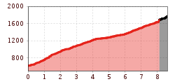
Route length: 8.6 km
Duration: 6:15 h

Trail Nr.: 26

Tour information

  • Requirement: medium
  • Length: 8.6 km
  • Duration: 6:15 h
  • Elevation uphill:1,170 hm
  • Elevation downhill:1,170 hm
Highest point1,773 m

Starting point

Parking Lot Unterbergbahn

Finishing point

Unterberg Summit Cross
  • Fitness level 3 / 6
  • Technique 3 / 6

Best time of year

  • January
  • February
  • March
  • April
  • May
  • June
  • July
  • August
  • September
  • October
  • November
  • December

Trail condition

Forest Road, Hiking Trail

Equipment

Breathable outdoor clothing suitable for the weather, sturdy footwear, food (snacks, drinks),
sun protection (sunglasses, sun cream & cap), rain protection, cash; guest card if using the bus
Source: TVB Kaiserwinkl

Description

Start in Kössen at the valley station of the Kössen mountain railways, following the Wiesenweg trail that branches off to the east. After a few minutes’ walk through the woods, the trail ascends in long, easy-to-hike switchbacks past a gate to the Scheibenwaldhütte (staffed). From there, continue on to the Bärenhütte (staffed, paragliding launch site) and the Gipfelhaus. From there, it’s about another half hour along a well-marked mountain trail to the Unterberghorn. The return trip can be made either by taking the same route or by taking the gondola.

Getting here

  • Arrival by public transport

    Take bus to the stop 'Unterberghornbahn'.
    (Or, if the bus does not go to that stop, get off at the 'Hüttwirt' stop instead.)

  • Parking

    Right next to the HochKössen cable car.

Weather

Today

light rain showers
28°C/16°C
70%6.3l5 km/h

Sun

light rain showers
29°C/16°C
50%3.1l5 km/h

Mon

light rain showers
32°C/16°C
45%1.7l5 km/h
Go to weather forecast

More tours in the surrounding area

Newsletter

The mountain is calling? So does our newsletter!

In our monthly newsletter we reveal the best holiday tips for Tyrol.