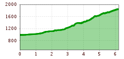
Mountain hikes Oberstdorf - Kemptner Hütte

Difficulty ratings: medium
Route length: 6.2 km
Duration: 8:15 h

Long-distance hiking trail E 5.

Tour information

  • Requirement: medium
  • Length: 6.2 km
  • Duration: 8:15 h
  • Elevation uphill:1,092 hm
Highest point1,850 m

Starting point

Oberstdorf Spielmannsau

Finishing point

Holzgau
  • Fitness level 3 / 6
  • Technique 3 / 6

Best time of year

  • January
  • February
  • March
  • April
  • May
  • June
  • July
  • August
  • September
  • October
  • November
  • December

Trail condition

Forest path, hiking trail

Equipment

Good equipment is essential for your hike. The following items should definitely be in your rucksack: - Food and drink - Functional clothing for rain, wind and cold - A change of clothes - Sun protection - First aid kit - Mobile phone with a full battery (Euro emergency number 112) - Hiking map or GPS - Hiking poles Nevertheless, the following applies: light luggage is also easier to carry, so you should not weigh down your rucksack with unnecessary ballast. In addition, your hiking equipment should of course also be adapted to your particular hiking tour.

Description

This hut approach first takes you along the Trettach, then over the wild Sperrbachtobel up to the beautifully situated Kemptner Hütte.

Nearby huts and mountain restaurants

Getting here

  • Arrival by public transport

    Hiking bus to Spielmannsau

  • Parking

    Parking lot at Oberstorf

More tours in the surrounding area

Newsletter

The mountain is calling? So does our newsletter!

In our monthly newsletter we reveal the best holiday tips for Tyrol.