Long-distance hike Ötztal Trek Stage 14

Sölden / Ötztaler Alpen
Difficulty ratings: difficult
Route length: 6.3 km
Duration: 3:00 h

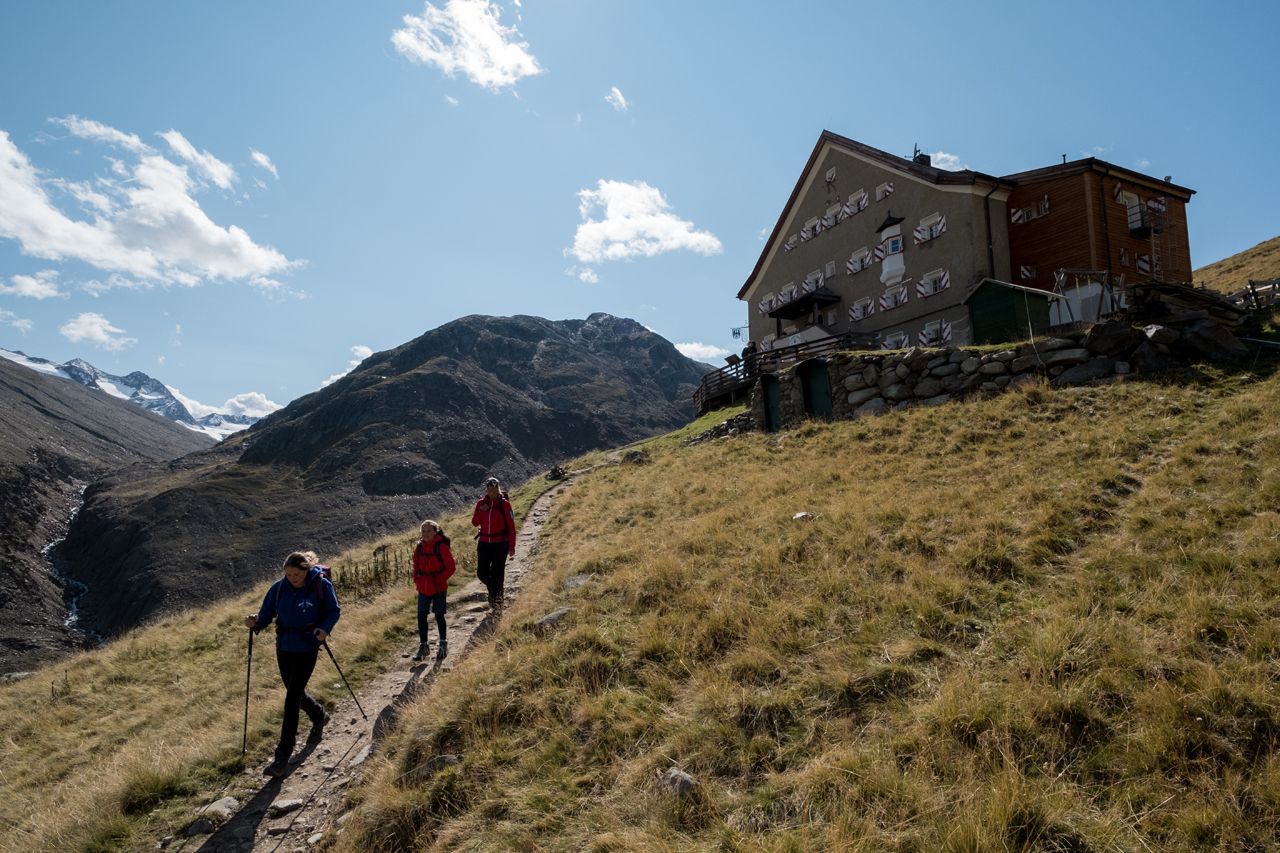
This day's stage is a highlight. The route: fantastic. The stage destination: a majestic glacier castle. The high alpine Brandenburger Haus is in a very exposed location and offers royal views of the Weißkugel, Langtaufererspitze and Hintere Hintereisspitze. The food: imperial and rated 99 points in the Falstaff Hüttenguide in 2024.

Tour character

Moderately difficult stage. Sure-footedness and high alpine experience are required. Passages over steep meadow slopes, boulders and rocks as well as glacier snow have to be overcome. Orientation for pathless terrain (pole markings) and a good level of fitness are required.

Tour information

  • Requirement: difficult
  • Length: 6.3 km
  • Duration: 3:00 h
  • Elevation uphill:1,004 hm
  • Elevation downhill:168 hm
Highest point3,247 m

Starting point

Hochjoch-Hospiz

Finishing point

Brandenburger Haus
  • Fitness level 5 / 6

Best time of year

  • January
  • February
  • March
  • April
  • May
  • June
  • July
  • August
  • September
  • October
  • November
  • December

Equipment

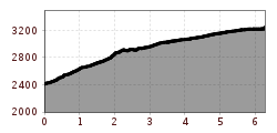
For surefooted, head-for-heights and highly alpine experienced mountaineers; excellent physical condition, comprehensive mountain experience, alpine climbing equipment, safety and orientation tools, good weather conditions recommended. Please observe the latest weather report

Appropriate equipment such as breathable and weather-appropriate outdoor clothing is required for all hikes and routes. Carrying a first aid kit, a mobile phone and possibly a hiking map, as well as sufficient provisions for hikes without dining options, is necessary.

Ice axe, crampons, rope | Mountain guide recommended.

Source: Ötztal

Description

  • Route: trail, path
  • Requirements: surefootedness, basic head-for-heights, high alpine experience
  • Black mountain trail, partly alpine route
  • Difficulties: passage over the Kesselwandferner (crevasses); mountain guide recommended!
  • Equipment: normal hiking equipment, crampons, ice axe depending on conditions; rope in any case; roping up on the glacier
  • Overnight stay, dining: Hochjoch-Hospiz, Brandenburger Haus
  • Cross-entry, -exit: from Vent through the Rofental to the Hochjoch-Hospiz (approx. 2.5 h ascent, approx. 2 h descent)

Nearby huts and mountain restaurants

Getting here

  • Arrival by public transport

    Travel comfortably and safely by train to the Ötztal train station. The final station or exit point is ÖTZTAL station. Afterwards, you travel conveniently and quickly by public bus or local taxi companies through the entire valley to your desired destination.

    The current bus timetable is available at: http://fahrplan.vvt.at

  • Parking

    In Vent, the following parking options are available:

    - at the entrance to Vent | paid | multi-day ticket possible

    - valley station of the chairlift | paid | multi-day ticket possible

More tours in the surrounding area

  • Ötztal Trek Stage 3

    Difficulty: difficult
    Length: 10.4 km Duration: 4:00 h Elevation uphill: 842 m
  • Ötztal Trek Stage 10

    Difficulty: difficult
    Length: 11.1 km Duration: 4:30 h Elevation uphill: 1,476 m
  • Ötztal Trek Stage 1

    Difficulty: medium
    Length: 18.6 km Duration: 6:30 h Elevation uphill: 1,561 m
  • Ötztal Trek Stage 11

    Difficulty: difficult
    Length: 12.0 km Duration: 5:00 h Elevation uphill: 705 m
  • Winter hiking trail Rotes Wandl - No. 431

    Opening hours: closed
    Difficulty: easy
    Length: 1.5 km Duration: 0:45 h Elevation uphill: 52 m
  • Ötztal Trek Stage 21

    Difficulty: difficult
    Length: 9.4 km Duration: 4:30 h Elevation uphill: 1,270 m
  • Ötztal Trek Stage 6

    Difficulty: difficult
    Length: 7.6 km Duration: 3:30 h Elevation uphill: 640 m
  • Ötztal Trek Stage 17

    Difficulty: difficult
    Length: 16.4 km Duration: 6:00 h Elevation uphill: 1,080 m
  • Mountain peak Rosskopf

    Difficulty: medium
    Length: 2.0 km Duration: 2:00 h Elevation uphill: 379 m
  • Mutsbühl

    Difficulty: medium
    Length: 4.5 km Duration: 1:30 h Elevation uphill: 470 m
  • Fundusfeiler - Umhausen

    Difficulty: difficult
    Length: 4.5 km Duration: 3:00 h Elevation uphill: 1,109 m
  • Wilder Mann

    Difficulty: medium
    Length: 2.4 km Duration: 2:30 h Elevation uphill: 665 m
  • Siegerlandhütte - Sölden

    Difficulty: medium
    Length: 8.0 km Duration: 3:30 h Elevation uphill: 780 m
  • Loop trail Stuibenfall Umhausen

    Opening hours: open
    Difficulty: easy
    Length: 9.2 km Duration: 4:00 h Elevation uphill: 608 m
  • Gampe Thaya

    Difficulty: medium
    Length: 2.6 km Duration: 1:45 h Elevation uphill: 623 m
  • Ramolhaus - Obergurgl

    Difficulty: difficult
    Length: 7.8 km Duration: 4:00 h Elevation uphill: 1,095 m
Newsletter

The mountain is calling? So does our newsletter!

In our monthly newsletter we reveal the best holiday tips for Tyrol.