Peternhof Circuit

Kössen / Chiemgau Alps
Difficulty ratings: easy
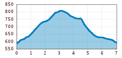
Route length: 7.0 km
Duration: 3:00 h

Trail Nr.: 2

Tour information

  • Requirement: easy
  • Length: 7.0 km
  • Duration: 3:00 h
  • Elevation uphill:220 hm
  • Elevation downhill:220 hm
Highest point811 m

Starting point

Kössen Information Office

Finishing point

Kössen Information Office

Features

  • Circular route
  • Suitable for families
Source: TVB Kaiserwinkl

Description

From the Kössen Information Office, turn left after the municipal office onto Mühlbergweg and continue to the Moosen fork in the road. (Caution: Do not turn right onto the road to Peternhof and then onto Moserbergweg before reaching this fork.) Now walk through a wooded area into an open field and continue on to the Peternhof. From the Peternhof, follow the road marked “Fritzing” downhill for about 200 m. Then turn right toward the Faistental farm. Continue to the pedestrian fork and turn left here into the Blaiken district, and from there back to the starting point.

Nearby huts and mountain restaurants

Getting here

  • Parking

    directly at the VZ  Kaiserwinkl

Weather

Today

light rain showers
27°C/15°C
75%12l5 km/h

Wed

light rain showers
27°C/16°C
70%5.4l5 km/h

Thu

mainly clear
28°C/15°C
50%2.7l5 km/h
Go to weather forecast

More tours in the surrounding area

Newsletter

The mountain is calling? So does our newsletter!

In our monthly newsletter we reveal the best holiday tips for Tyrol.